File:Bratislava boroughs map.svg
Jump to navigation
Jump to search

Size of this PNG preview of this SVG file: 525 × 599 pixels. Other resolutions: 210 × 240 pixels | 421 × 480 pixels | 673 × 768 pixels | 897 × 1,024 pixels | 1,795 × 2,048 pixels | 1,036 × 1,182 pixels.
Original file (SVG file, nominally 1,036 × 1,182 pixels, file size: 405 KB)
Captions
Captions
Add a one-line explanation of what this file represents
Summary[edit]
| Description |
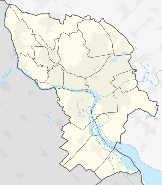
Slovenčina: Mapa mestských častí Bratislavy
Čeština: Mapa městských částí Bratislavy
English: Map of Bratislava boroughs
Deutsch: Karte der Stadtteile von Bratislava |
||||||
| Date | |||||||
| Source | Own work, using OpenStreetMap data | ||||||
| Author | Krumpi | ||||||
| Other versions |
|
||||||
| SVG development |


Licensing[edit]
I, the copyright holder of this work, hereby publish it under the following license:
This file is licensed under the Creative Commons Attribution-Share Alike 4.0 International license.
- You are free:
- to share – to copy, distribute and transmit the work
- to remix – to adapt the work
- Under the following conditions:
- attribution – You must give appropriate credit, provide a link to the license, and indicate if changes were made. You may do so in any reasonable manner, but not in any way that suggests the licensor endorses you or your use.
- share alike – If you remix, transform, or build upon the material, you must distribute your contributions under the same or compatible license as the original.
File history
Click on a date/time to view the file as it appeared at that time.
| Date/Time | Thumbnail | Dimensions | User | Comment | |
|---|---|---|---|---|---|
| current | 18:15, 11 January 2020 | | 1,036 × 1,182 (405 KB) | Krumpi (talk | contribs) |
You cannot overwrite this file.
File usage on Commons
The following 6 pages use this file:
File usage on other wikis
The following other wikis use this file:
- Usage on en.wikipedia.org
- Usage on hu.wikipedia.org
- Pozsonyi hídfő
- Comenius Egyetem
- Erzsébet Tudományegyetem
- Szlovák Nemzeti Színház
- Dévény vára
- Zerge-hegy (Kis-Kárpátok)
- Pozsonyi sortűz
- Kikötői híd
- Pozsonyi vashonvéd
- Pozsony főpályaudvar
- Pozsonyi kikötő
- Emericanum
- Pozsony-Szőlőhegy megállóhely
- Oroszvár vasútállomás
- Pozsonyligetfalu vasútállomás
- Sablon:Pozíciós térkép Pozsony
- Pozsony-Újváros vasútállomás
- Pozsonyi Autógyár
- Vödric
- Magyarország pozsonyi nagykövetsége
- Szűz Mária-templom (Vereknye)
- Szlovénia pozsonyi nagykövetsége
- Lengyelország pozsonyi nagykövetsége
- Pozsonypüspöki vasútállomás
- Pozsonyi Magyar Szakkollégium
- Pozsonyi Képzőművészeti Főiskola
- Pozsonyi Színművészeti Főiskola
- Pozsonyi Közgazdaságtudományi Egyetem
- Szlovák Műszaki Egyetem
- Pozsonyi Rendőrakadémia
- Szlovák Egészségügyi Egyetem
- Pozsonyi Közigazgatási, Közgazdaságtudományi és Menedzsment Főiskola
- Pozsonyi Nemzetközi Szabad Művészeti Iskola
- Szent Erzsébet Egészségügyi és Szociális Munka Főiskola
- Páneurópai Főiskola
- Gimnázium (Pozsony, Grösslingová 18)
- Pozsonyi Evangélikus Líceum
- Szlovák Jégkorongszövetség
- Slavín