File:Brasil-Politico-Mapa-IBGE.svg
Jump to navigation
Jump to search

Size of this PNG preview of this SVG file: 800 × 566 pixels. Other resolutions: 320 × 226 pixels | 640 × 453 pixels | 1,024 × 724 pixels | 1,280 × 905 pixels | 2,560 × 1,810 pixels | 1,123 × 794 pixels.
Original file (SVG file, nominally 1,123 × 794 pixels, file size: 20.73 MB)
Captions
Captions
Add a one-line explanation of what this file represents
Summary[edit]
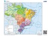
| Description |
中文:巴西政治地图,包括巴西的州和城市。
English: Political Map of Brazil with the States and Cities of Brazil.
हिन्दी: ब्राजील का राजनीतिक मानचित्र ब्राजील के राज्यों और शहरों सहित।
Español: Mapa político de Brasil con los estados y ciudades de Brasil.
العربية: خريطة البرازيل السياسية مع ولايات ومدن البرازيل.
বাংলা: ব্রাজিলের রাজ্য এবং শহর সহ ব্রাজিলের রাজনৈতিক মানচিত্র।
Português: Mapa Brasil Político com os Estados e Cidades do Brasil.
Русский: Политическая карта Бразилии с штатами и городами Бразилии.
日本語: ブラジルの州と都市を含むブラジルの政治地図。
Français : Carte politique du Brésil avec les États et les villes du Brésil.
Українська: Політична карта Бразилії з штатами та містами Бразилії.
Dansk: Politisk kort over Brasilien med Brasiliens stater og byer.
Esperanto: Politika mapo de Brazilo kun la ŝtatoj kaj urboj de Brazilo. |
| Date | |
| Source | IBGE, Diretoria de Geociências, Coordenação de Cartografia (English: IBGE, Directorate of Geosciences, Coordination of Cartography), https://atlasescolar.ibge.gov.br/images/atlas/mapas_brasil/brasil_politico.pdf |
| Author | Unknown author |
| Permission (Reusing this file) |
This file is licensed under the Creative Commons Attribution-Share Alike 3.0 Unported license.
|
| Other versions | |
| SVG development | This vector image was extracted with Inkscape. |
File history
Click on a date/time to view the file as it appeared at that time.
| Date/Time | Thumbnail | Dimensions | User | Comment | |
|---|---|---|---|---|---|
| current | 20:00, 19 September 2023 | | 1,123 × 794 (20.73 MB) | Zhing'za zï Ïnin (talk | contribs) | fixed broken text spacing |
| 19:21, 19 September 2023 |  | 1,123 × 794 (19.07 MB) | Zhing'za zï Ïnin (talk | contribs) | {{Information |Description= {{zh|巴西政治地图,包括巴西的州和城市。}} {{en|Political Map of Brazil with the States and Cities of Brazil.}} {{hi|ब्राजील का राजनीतिक मानचित्र ब्राजील के राज्यों और शहरों सहित।}} {{es|Mapa político de Brasil con los estados y ciudades de Brasil.}} {{ar|خريطة البرازيل السياسية مع ولايات ومدن البرازيل.}} {{bn|ব্রাজিলের রাজ্য এবং শহর সহ ব্রাজিলের রাজনৈতিক মানচিত্র।}} {{pt|Mapa Brasil Político com os Estados e Cidades do Brasil.}} {{ru|Политическая карта Бразилии с штатами и городами... |
You cannot overwrite this file.
File usage on Commons
The following page uses this file: