File:Brandenburg Kreise (nummeriert).svg
Jump to navigation
Jump to search

Size of this PNG preview of this SVG file: 401 × 401 pixels. Other resolutions: 240 × 240 pixels | 480 × 480 pixels | 768 × 768 pixels | 1,024 × 1,024 pixels | 2,048 × 2,048 pixels.
Original file (SVG file, nominally 401 × 401 pixels, file size: 37 KB)
Captions
Captions
Add a one-line explanation of what this file represents
| Description |
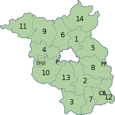
Deutsch: Karte des Landes Brandenburg mit eingezeichneter Kreiseinteilung und alphabetischer Nummerierung der Landkreise. Die kreisfreien Städte sind mit Buchstaben angegeben. |
| Date | |
| Source | Erstellt aus Material des gemeinsamen Datenangebotes aus dem gemeinsamen Portal der statistischen Ämter des Bundes und der Länder (DeStatis). [1] |
| Author | David Liuzzo |
| Permission (Reusing this file) |
This file is licensed under the Creative Commons Attribution-Share Alike 2.0 Germany license.
 |
File history
Click on a date/time to view the file as it appeared at that time.
| Date/Time | Thumbnail | Dimensions | User | Comment | |
|---|---|---|---|---|---|
| current | 15:14, 16 October 2006 | | 401 × 401 (37 KB) | David Liuzzo (talk | contribs) | {{Information| |Description= {{de|Karte des Landes Brandenburg mit eingezeichneter Kreiseinteilung und alphabetischer Nummerierung der Landkreise. Die kreisfreien Städte sind mit Buchstaben angegeben.}} |Source= Erst |
You cannot overwrite this file.
File usage on Commons
The following page uses this file:
File usage on other wikis
The following other wikis use this file:
- Usage on af.wikipedia.org
- Usage on an.wikipedia.org
- Usage on cs.wikipedia.org
- Usage on dsb.wikipedia.org
- Usage on es.wikipedia.org
- Usage on fy.wikipedia.org
- Usage on gd.wikipedia.org
- Usage on hsb.wikipedia.org
- Usage on hu.wikipedia.org
- Usage on it.wikipedia.org
- Usage on ko.wikipedia.org
- Usage on pl.wikipedia.org
- Usage on pt.wikipedia.org
- Usage on qu.wikipedia.org
.svg&oldid=831583911)