File:Brackenheim Flurkarte 1835 retuschiert.jpg

Original file (5,828 × 5,337 pixels, file size: 8.16 MB, MIME type: image/jpeg)
Captions
Captions
Summary[edit]
| Description |
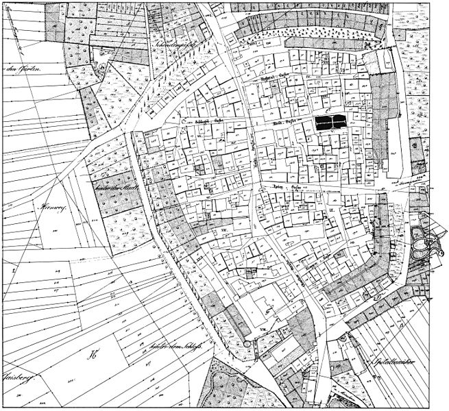
English: Historical town map of Brackenheim (Baden-Württemberg, Germany) in 1835, from an old plat (Flurkarte).
This is a retouched image file: some points of the image have been reconstructed (see German description for details). Deutsch: Historischer Stadtplan der Altstadt von Brackenheim (Landkreis Heilbronn, Baden-Württemberg) im Jahre 1835, aus einer alten Flurkarte. Es handelt sich um eine retuschierte Datei. Die Reproduktion der Flurkarte im Heimatbuch, die als Vorlage diente, wird durch zahlreiche Ziffern gestört, die man teils über der historischen Gebäudenummerierung eingesetzt hat. Ich habe diese neuen Ziffern entfernt, da sie störend, hässlich und unnötig sind und zudem ihr Copyright (wenn sie die nötige Schöpfungshöhe erreichen würden, was aber nicht der Fall ist) bei den Autoren des Heimatbuches läge. Dabei mussten die von diesen Ziffern überdeckten Punkte der Zeichnung rekonstruiert werden, wobei Fehler (etwa bei der Gebäudenummerierung) nicht zu 100% ausgeschlossen werden können. Es handelt sich daher hier um eine punktuell rekonstruierte Wiedergabe der Flurkarte, die jedoch für praktische, historiografische und edukative Zwecke völlig ausreicht. Eine wirklich bessere Reproduktion wäre nur anhand des Originals der Flurkarte möglich. |
| Date | |
| Source |
English: Scanned from the book Brackenheim. Heimatbuch der Stadt Brackenheim und ihrer Stadtteile, redaction: Wolfram Angerbauer, Brackenheim 1980, p. 254 by Aristeas.
Deutsch: Aus dem Buch Brackenheim. Heimatbuch der Stadt Brackenheim und ihrer Stadtteile, Redaktion: Wolfram Angerbauer, Brackenheim 1980, S. 254 von Aristeas gescannt. |
| Author |
English: Author of original map unknown. Scan created and edited by Aristeas.
Deutsch: Zeichner des Originals (Flurkarte) unbekannt. Gescannt und retuschiert von Aristeas. |
| This is a retouched picture, which means that it has been digitally altered from its original version. Modifications: Removed some modern additions, see description for details..
|
Licensing[edit]
This image is in the public domain because it is a mere mechanical scan or photocopy of a public domain original, or – from the available evidence – is so similar to such a scan or photocopy that no copyright protection can be expected to arise. The original itself is in the public domain for the following reason:
This tag is designed for use where there may be a need to assert that any enhancements (eg brightness, contrast, colour-matching, sharpening) are in themselves insufficiently creative to generate a new copyright. It can be used where it is unknown whether any enhancements have been made, as well as when the enhancements are clear but insufficient. For known raw unenhanced scans you can use an appropriate {{PD-old}} tag instead. For usage, see Commons:When to use the PD-scan tag.  | ||||
| Annotations | This image is annotated: View the annotations at Commons |
| Object location | | View this and other nearby images on: OpenStreetMap |
|---|
File history
Click on a date/time to view the file as it appeared at that time.
| Date/Time | Thumbnail | Dimensions | User | Comment | |
|---|---|---|---|---|---|
| current | 08:52, 18 November 2010 | | 5,828 × 5,337 (8.16 MB) | Aristeas (talk | contribs) | {{Information |Description={{en|1=Historical town map of Brackenheim (Baden-Württemberg, Germany) in 1835, from an old plat (Flurkarte).}} {{de|1=Historischer Stadtplan der Altstadt von [[:de:Brackenh |
You cannot overwrite this file.
File usage on Commons
The following page uses this file:
File usage on other wikis
The following other wikis use this file:
- Usage on azb.wikipedia.org
- Usage on de.wikipedia.org
- Usage on uk.wikipedia.org