File:Bornish machair - geograph.org.uk - 242616.jpg
From Wikimedia Commons, the free media repository
Jump to navigation
Jump to search
Bornish_machair_-_geograph.org.uk_-_242616.jpg (640 × 372 pixels, file size: 106 KB, MIME type: image/jpeg)
File information
Structured data
Captions
Summary[edit]
DescriptionBornish machair - geograph.org.uk - 242616.jpg |
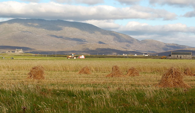
English: Bornish machair. The mixed barley/oat "stooks" are part of a project to conserve the Corn Bunting, a bird which has a significant part of its population in this part of Scotland. Beinn Mhor in the background. |
||
Date | |||
Source | geograph.org.uk | ||
Author | Mary and Angus Hogg | ||
Permission (Reusing this file) |
This file is licensed under the Creative Commons Attribution-Share Alike 2.0 Generic license. Attribution: Mary and Angus Hogg
|
||
Attribution (required by the license) InfoField | Mary and Angus Hogg / Bornish machair / | ||
InfoField | Mary and Angus Hogg / Bornish machair |
Camera location | 57° 14′ 30″ N, 7° 25′ 55″ W | View this and other nearby images on: OpenStreetMap | 57.241700; -7.432000 |
---|
File history
Click on a date/time to view the file as it appeared at that time.
Date/Time | Thumbnail | Dimensions | User | Comment | |
---|---|---|---|---|---|
current | 22:37, 31 January 2010 | 640 × 372 (106 KB) | GeographBot (talk | contribs) | == {{int:filedesc}} == {{Information |description={{en|1=Bornish machair. The mixed barley/oat "stooks" are part of a project to conserve the Corn Bunting, a bird which has a significant part of its population in this part of Scotland. Beinn Mhor in the |
You cannot overwrite this file.
File usage on Commons
There are no pages that use this file.
File usage on other wikis
The following other wikis use this file:
- Usage on lt.wikipedia.org
Metadata
This file contains additional information such as Exif metadata which may have been added by the digital camera, scanner, or software program used to create or digitize it. If the file has been modified from its original state, some details such as the timestamp may not fully reflect those of the original file. The timestamp is only as accurate as the clock in the camera, and it may be completely wrong.
Camera manufacturer | NIKON CORPORATION |
---|---|
Camera model | NIKON D50 |
Exposure time | 1/250 sec (0.004) |
F-number | f/10 |
Date and time of data generation | 16:54, 8 September 2006 |
Lens focal length | 50 mm |
Orientation | Normal |
Horizontal resolution | 300 dpi |
Vertical resolution | 300 dpi |
Software used | PictureProject 1.5 W |
File change date and time | 12:12, 17 September 2006 |
Y and C positioning | Centered |
Exposure Program | Not defined |
Exif version | 2.21 |
Date and time of digitizing | 16:54, 8 September 2006 |
APEX exposure bias | 0 |
Maximum land aperture | 4 APEX (f/4) |
Metering mode | Pattern |
Light source | Unknown |
Flash | Flash did not fire, compulsory flash suppression |
DateTime subseconds | 00 |
DateTimeOriginal subseconds | 00 |
DateTimeDigitized subseconds | 00 |
Color space | Uncalibrated |
Sensing method | One-chip color area sensor |
Structured data
Items portrayed in this file
depicts
some value
8 September 2006
57°14'30.1"N, 7°25'55.2"W
image/jpeg
376095f2dee89afd3913a662a3d0512e95373fc8
108,440 byte
372 pixel
640 pixel
Hidden categories:
- CC-BY-SA-2.0
- Images from Geograph Britain and Ireland
- Images from Geograph Britain and Ireland missing SDC coordinates of depicted place
- Information field template with formatting
- Files with coordinates missing SDC location of creation
- Images by Mary and Angus Hogg
- United Kingdom photographs taken on 2006-09-08
- Pages with maps