File:Bonfeld - Plan der Schlösser von 1775 - gezeichnet von J. C. Waydelin - 300ppi.jpg

Original file (1,231 × 1,711 pixels, file size: 3.05 MB, MIME type: image/jpeg)
Captions
Captions
Summary[edit]
| Description |
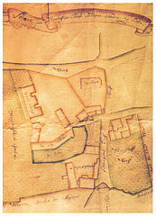
English: Map of the castles in Bonfeld (today a district of Bad Rappenau, Germany), drawn in 1775 by J. C. Waydelin (according to the information given in the Heimatbuch Bonfeld (Bad Rappenau 2000), page 133).
Deutsch: Plan der Schlösser in Bonfeld (heute Ortsteil von Bad Rappenau, Baden-Württemberg), 1775 von J. C. Waydelin gezeichnet (gemäß den Angaben im Heimatbuch Bonfeld (Bad Rappenau 2000), S. 133). |
||
| Date | |||
| Source | Scanned from the reproduction in the Heimatbuch Bonfeld (Bad Rappenau 2000), page 132, fig. 90 | ||
| Author | J. C. Waydelin (original map); scanned by Aristeas | ||
| Permission (Reusing this file) |
There are no copyright problems, because the reproduction in the Heimatbuch is a simple reproduction which does not create any copyright, and the creator of the original map is definitely dead for more than 100 years. | ||
| Other versions |
|

| Color space | This image file uses the sRGB colour space. (Fortunately today most systems and applications respect colour spaces and ICC profiles. But there may still be some exceptions: outdated or misconfigured software can display wrong colours. If you see strange colours or if the picture appears flat and low in contrast, you should try another application or device for viewing it.) |
Licensing[edit]
This image is in the public domain because it is a mere mechanical scan or photocopy of a public domain original, or – from the available evidence – is so similar to such a scan or photocopy that no copyright protection can be expected to arise. The original itself is in the public domain for the following reason:
This tag is designed for use where there may be a need to assert that any enhancements (eg brightness, contrast, colour-matching, sharpening) are in themselves insufficiently creative to generate a new copyright. It can be used where it is unknown whether any enhancements have been made, as well as when the enhancements are clear but insufficient. For known raw unenhanced scans you can use an appropriate {{PD-old}} tag instead. For usage, see Commons:When to use the PD-scan tag.  | ||||
| Annotations | This image is annotated: View the annotations at Commons |
File history
Click on a date/time to view the file as it appeared at that time.
| Date/Time | Thumbnail | Dimensions | User | Comment | |
|---|---|---|---|---|---|
| current | 12:42, 10 January 2015 | | 1,231 × 1,711 (3.05 MB) | Aristeas (talk | contribs) | == {{int:filedesc}} == {{Compressed version|file=Bonfeld - Plan der Schlösser von 1775 - gezeichnet von J. C. Waydelin.png}} {{Information |Description ={{en|1=Map of the castles in Bonfeld (today a district of Bad Rappenau, Germ... |
You cannot overwrite this file.
File usage on Commons
The following 4 pages use this file: