File:Bohus fästning - KMB - 16001000030052.jpg

Original file (804 × 529 pixels, file size: 98 KB, MIME type: image/jpeg)
Captions
Captions
| Bohus fästning
( |
|||||||||||||||||||||||||||
|---|---|---|---|---|---|---|---|---|---|---|---|---|---|---|---|---|---|---|---|---|---|---|---|---|---|---|---|
| Photographer |
|
||||||||||||||||||||||||||
| Title |
Bohus fästning |
||||||||||||||||||||||||||
| Original caption |
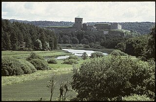
Notera Av dokumentationsskäl har originalbeskrivningen från Riksantikvarieämbetet behållits. Tillrättalägganden och alternativa beskrivningar bör införas separat från nedanstående information. Kungälvs gamla stad - Bohus Fästning. En av Nordens mest välbevarade trästäder med bebyggelse från 1700- och 1800-tal. Staden ligger invid gränsfästet Bohus, med anor från tidigt 1300-tal och uppförd i ett strategiskt läge vid Nordre Älv. Hit flyttade efter 1612 staden Kungahällas innebyggare och en ny stad uppfördes på fästningsholmen. Platsen övergavs till förmån för läget av dagens Kungälv, som uppstod i slutet av 1600-talet.Felaktigheter kan även anmälas till denna sida. Motiv: Kungälv 9:1 |
||||||||||||||||||||||||||
| Description |
Kungälvs gamla stad - Bohus Fästning. En av Nordens mest välbevarade trästäder med bebyggelse från 1700- och 1800-tal. Staden ligger invid gränsfästet Bohus, med anor från tidigt 1300-tal och uppförd i ett strategiskt läge vid Nordre Älv. Hit flyttade efter 1612 staden Kungahällas innebyggare och en ny stad uppfördes på fästningsholmen. Platsen övergavs till förmån för läget av dagens Kungälv, som uppstod i slutet av 1600-talet. Kungälv 9:1.
|
||||||||||||||||||||||||||
| Depicted place | Sweden, Kungälv Municipality, Q10550420 | ||||||||||||||||||||||||||
| Date | 1985 | ||||||||||||||||||||||||||
| Collection |
|
||||||||||||||||||||||||||
| Accession number | |||||||||||||||||||||||||||
| Source |
John-Eric Gustafsson / Kulturmiljöbild, Riksantikvarieämbetet
|
||||||||||||||||||||||||||
| Permission (Reusing this file) |
This file is licensed under the Creative Commons Attribution 2.5 Generic license. Attribution: John-Eric Gustafsson / Riksantikvarieämbetet
|
||||||||||||||||||||||||||


| Object location | | View this and other nearby images on: OpenStreetMap |
|---|
File history
Click on a date/time to view the file as it appeared at that time.
| Date/Time | Thumbnail | Dimensions | User | Comment | |
|---|---|---|---|---|---|
| current | 14:12, 11 July 2017 | | 804 × 529 (98 KB) | AndreCostaWMSE-bot (talk | contribs) | {{Kulturmiljöbild-image | short title = Bohus fästning | original description = Kungälvs gamla stad - Bohus Fästning. En av Nordens mest välbevarade trästäder med bebyggelse från 1700- och 1800-tal. Staden ligger invid gränsfästet Bohus, med... |
You cannot overwrite this file.
File usage on Commons
The following 2 pages use this file:
File usage on other wikis
The following other wikis use this file:
- Usage on sv.wikipedia.org