File:Blueprint sketch map of Qatar in 1939.jpg
Jump to navigation
Jump to search

Size of this preview: 462 × 599 pixels. Other resolutions: 185 × 240 pixels | 370 × 480 pixels | 592 × 768 pixels | 790 × 1,024 pixels | 1,489 × 1,930 pixels.
Original file (1,489 × 1,930 pixels, file size: 686 KB, MIME type: image/jpeg)
Captions
Captions
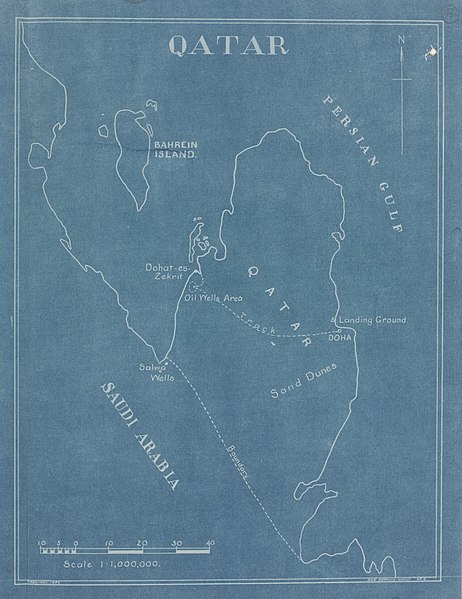
Blueprint sketch map of Qatar drawn in February 1939 to illustrate the oil infrastructure of Dukhan.
Summary
[edit]
| Description |
English: Blueprint sketch map of Qatar drawn in February 1939 to illustrate the oil infrastructure of Dukhan, the path leading there, the boundary between Qatar and Saudi Arabia and the landing grounds in Doha. |
| Date | |
| Source | Qatar Digital Library |
| Author | Drawing Office of the British Air Headquarters in Iraq |
Licensing
[edit]
_(St_Edwards_Crown).svg)
|
This file is licensed under the United Kingdom Open Government Licence v2.0. |
See also: Meta for information on usage on Wikimedia wikis.
|
File history
Click on a date/time to view the file as it appeared at that time.
| Date/Time | Thumbnail | Dimensions | User | Comment | |
|---|---|---|---|---|---|
| current | 04:03, 15 February 2019 | | 1,489 × 1,930 (686 KB) | Elspamo4 (talk | contribs) | Cropped 50 % horizontally, 20 % vertically using CropTool with precise mode. |
| 04:01, 15 February 2019 |  | 3,000 × 2,412 (979 KB) | Elspamo4 (talk | contribs) | User created page with UploadWizard |
You cannot overwrite this file.
File usage on Commons
There are no pages that use this file.
File usage on other wikis
The following other wikis use this file:
- Usage on en.wikipedia.org