File:Blacktoft Jetty - geograph.org.uk - 635693.jpg
Blacktoft_Jetty_-_geograph.org.uk_-_635693.jpg (640 × 452 pixels, file size: 80 KB, MIME type: image/jpeg)
Captions
Captions
Summary
[edit]
| Description |
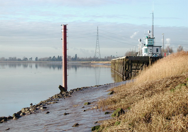
English: Blacktoft Jetty, Blacktoft, East Riding of Yorkshire, England. Looking west along the north bank of the River Ouse near Pier House, Blacktoft. The original 470ft long jetty was built between 1873 and 1881 by the Aire & Calder Navigation Company to provide a stopover for those vessels which required two high tides to travel from Hull to Goole. It was used by the paddle steamers of the Humber Steam Packet Service until about 1920, and later the local Hope & Anchor pub became well known to foreign sailors from as far away as Copenhagen and St Petersburg. During the second world war the infamous propagandist Lord Haw Haw announced that "Blacktoft docks have been bombed" when presumably he meant Hull, although Hull was in fact getting hit all the time as enemy aircraft frequently dropped unused payloads on the city when returning from raids further west. In 1947 in his book "English Rivers", John Rogers described Blacktoft as follows: "The country on either side is remote and lonely. The expanse of flat fields is broken only by occasional hamlets, hardly touched by road or rail. The few cottages at Blacktoft are so sequestered that a stranger is stared at in astonishment. To laze at Blacktoft jetty, gazing across the wide expanse of river, with Trent Falls barely visible on the opposite side, is to feel strangely remote from men". Part of the old wooden jetty was replaced by a more modern one in 1956. The remains of the "Old Blacktoft Pier" are still marked on O/S maps but have now gone. |
| Date | |
| Source | From geograph.org.uk |
| Author | Paul Glazzard |
| Permission (Reusing this file) |
Creative Commons Attribution Share-alike license 2.0 |
| Attribution (required by the license) | Paul Glazzard / Blacktoft Jetty / |
| Camera location | | View this and other nearby images on: OpenStreetMap |
|---|
_heading:270.00&language=en)
| Object location | | View this and other nearby images on: OpenStreetMap |
|---|
_heading:270.00&language=en)
Licensing
[edit]

|
This image was taken from the Geograph project collection. See this photograph's page on the Geograph website for the photographer's contact details. The copyright on this image is owned by Paul Glazzard and is licensed for reuse under the Creative Commons Attribution-ShareAlike 2.0 license.
|
- You are free:
- to share – to copy, distribute and transmit the work
- to remix – to adapt the work
- Under the following conditions:
- attribution – You must give appropriate credit, provide a link to the license, and indicate if changes were made. You may do so in any reasonable manner, but not in any way that suggests the licensor endorses you or your use.
- share alike – If you remix, transform, or build upon the material, you must distribute your contributions under the same or compatible license as the original.
File history
Click on a date/time to view the file as it appeared at that time.
| Date/Time | Thumbnail | Dimensions | User | Comment | |
|---|---|---|---|---|---|
| current | 08:40, 7 February 2011 | | 640 × 452 (80 KB) | GeographBot (talk | contribs) | == {{int:filedesc}} == {{Information |description={{en|1=Blacktoft Jetty Looking west along the north bank of the River Ouse near Pier House, Blacktoft. The original 470ft long jetty was built between 1873 and 1881 by the Aire & Calder Navigation Comp |
You cannot overwrite this file.
File usage on Commons
There are no pages that use this file.