File:Biafra independent state map-de.svg
Jump to navigation
Jump to search

Size of this PNG preview of this SVG file: 776 × 600 pixels. Other resolutions: 311 × 240 pixels | 621 × 480 pixels | 994 × 768 pixels | 1,280 × 989 pixels | 2,560 × 1,978 pixels | 1,100 × 850 pixels.
Original file (SVG file, nominally 1,100 × 850 pixels, file size: 455 KB)
Captions
Captions
Add a one-line explanation of what this file represents

|
This SVG file contains embedded text that can be translated into your language, using any capable SVG editor, text editor or the SVG Translate tool. For more information see: About translating SVG files. |
Summary[edit]
| Description |
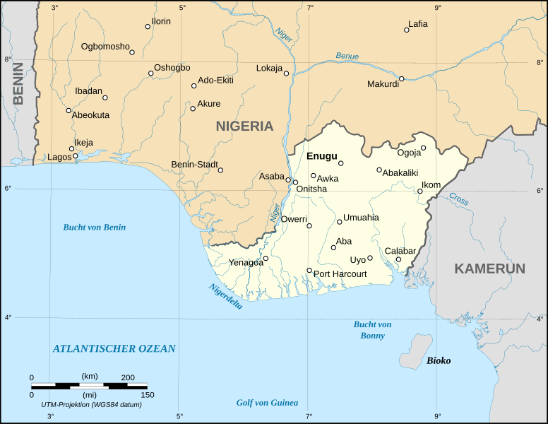
English: Map of the secessionist state of the Republic of Biafra (1967 – 1970) as in May 1967.
Note: The western boundary may not be accurate due to the low precision of the reference maps used which are also contradictory. UTM projection ; WGS 84 datum |
| Date | September 2008 (new version) |
| Source |
Own work
|
| Author | Eric Gaba (Sting - fr:Sting), Translation: Bohr |
| Permission (Reusing this file) |
GFDL + CC-BY-SA |
| Other versions |
[]
|


Licensing[edit]

|
Permission is granted to copy, distribute and/or modify this document under the terms of the GNU Free Documentation License, Version 1.2 or any later version published by the Free Software Foundation; with no Invariant Sections, no Front-Cover Texts, and no Back-Cover Texts. A copy of the license is included in the section entitled GNU Free Documentation License. |
| This file is licensed under the Creative Commons Attribution-Share Alike 3.0 Unported license. | ||
| ||
| This licensing tag was added to this file as part of the GFDL licensing update. |
File history
Click on a date/time to view the file as it appeared at that time.
| Date/Time | Thumbnail | Dimensions | User | Comment | |
|---|---|---|---|---|---|
| current | 13:22, 3 September 2008 | | 1,100 × 850 (455 KB) | Sting (talk | contribs) | Oup : forgot to delete a hidden layer |
| 13:19, 3 September 2008 |  | 1,100 × 850 (494 KB) | Sting (talk | contribs) | New map using NGDC GSHHS and WDBII data ; new standard colors ; boundaries correction | |
| 19:55, 18 December 2006 |  | 1,100 × 850 (162 KB) | Bohr~commonswiki (talk | contribs) | == Summary == {{Information| |Description=Map of the secessionist state of the Republic of Biafra (1967 – 1970) in German |Source=Own work<br/>Background reference map : Microsoft Encarta atlas (1999 edition)<br/>Biafra independent state borders referen |
You cannot overwrite this file.
File usage on Commons
The following 9 pages use this file:
- File:Biafra independent state map-ar.svg
- File:Biafra independent state map-de.svg
- File:Biafra independent state map-en.svg
- File:Biafra independent state map-fr.svg
- File:Biafra independent state map-it.svg
- File:Biafra independent state map-jp.svg
- File:Biafra independent state map-mk.svg
- File:Biafra independent state map-ru.svg
- Template:Other versions/Biafra independent state map
File usage on other wikis
The following other wikis use this file:
- Usage on als.wikipedia.org
- Usage on cs.wikipedia.org
- Usage on de.wikipedia.org
- Usage on eo.wikipedia.org
- Usage on frr.wikipedia.org
- Usage on sk.wikipedia.org