File:Belmont at Sweetbriar, Nashville.jpg
Jump to navigation
Jump to search

Size of this preview: 800 × 450 pixels. Other resolutions: 320 × 180 pixels | 640 × 360 pixels | 1,024 × 576 pixels | 1,280 × 720 pixels | 2,816 × 1,584 pixels.
Original file (2,816 × 1,584 pixels, file size: 1.82 MB, MIME type: image/jpeg)
Captions
Captions
Add a one-line explanation of what this file represents
|
This is an image of a place or building that is listed on the National Register of Historic Places in the United States of America. Its reference number is 80003784. |
| Camera location | | View this and other nearby images on: OpenStreetMap |
|---|
| Description |
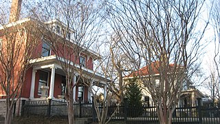
English: Houses on the northwestern corner of the junction of Sweetbriar Avenue and Belmont Boulevard in Nashville, Tennessee, United States. This block is part of the Belmont-Hillsboro Historic District, a historic district that is listed on the National Register of Historic Places. |
||
| Date | Taken on 20 January 2014 | ||
| Source | Own work | ||
| Author | Nyttend | ||
| Permission (Reusing this file) |
|
File history
Click on a date/time to view the file as it appeared at that time.
| Date/Time | Thumbnail | Dimensions | User | Comment | |
|---|---|---|---|---|---|
| current | 03:56, 2 February 2014 | | 2,816 × 1,584 (1.82 MB) | Nyttend (talk | contribs) | {{NRHP|80003784}} {{Location|36|7|30|N|86|47|40|W}} {{Information |Description={{en|Houses on the northwestern corner of the junction of Sweetbriar Avenue and Belmont Boulevard in {{w|Nashville, Tennessee|Nashville}}, {{w|Tennessee}}, {{w|United States... |
You cannot overwrite this file.
File usage on Commons
The following 2 pages use this file:
File usage on other wikis
The following other wikis use this file:
- Usage on en.wikipedia.org
- Usage on ja.wikipedia.org
- Usage on www.wikidata.org