File:Belle-Île-en-Mer administrative map-fr.svg
Jump to navigation
Jump to search

Size of this PNG preview of this SVG file: 764 × 600 pixels. Other resolutions: 306 × 240 pixels | 611 × 480 pixels | 978 × 768 pixels | 1,280 × 1,005 pixels | 2,560 × 2,010 pixels | 1,118 × 878 pixels.
Original file (SVG file, nominally 1,118 × 878 pixels, file size: 1.16 MB)
Captions
Captions
Add a one-line explanation of what this file represents
| Description |
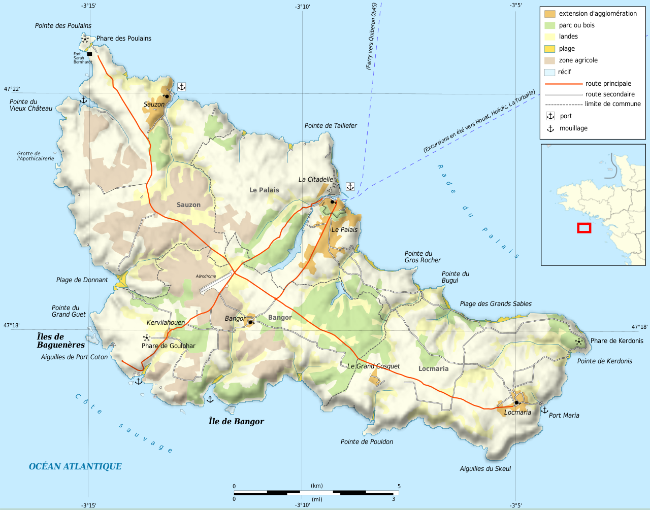
Français : Carte administrative en français de Belle-Île-en-Mer Deutsch: Verwaltungskarte zum Belle-Île, in Französische English: Administrative map in French of Belle Île Español: Mapa administrativo en francès de Belle-Île-en-Mer Italiano: Carta amministrativa de Belle Île 日本語: フランス語で表示したベル・イル島の行政地図 Português: Carta da administração do Belle-Isle em francês |
||||
| Date | |||||
| Source |
Français : Création personnelle ;
English: Own work ;
|
||||
| Author | Bourrichon - fr:Bourrichon | ||||
| Permission (Reusing this file) |
I, the copyright holder of this work, hereby publish it under the following licenses:
This file is licensed under the Creative Commons Attribution-Share Alike 3.0 Unported, 2.5 Generic, 2.0 Generic and 1.0 Generic license.
You may select the license of your choice. |
||||
| Other versions |
[]
|


|
This SVG file contains embedded text that can be translated into your language, using any capable SVG editor, text editor or the SVG Translate tool. For more information see: About translating SVG files. |
This W3C-unspecified vector image was created with Inkscape .
File history
Click on a date/time to view the file as it appeared at that time.
| Date/Time | Thumbnail | Dimensions | User | Comment | |
|---|---|---|---|---|---|
| current | 20:14, 23 May 2010 | | 1,118 × 878 (1.16 MB) | Bourrichon (talk | contribs) | {{Information |Description= {{fr|Carte administrative en français de Belle-Île-en-Mer}}{{de|Verwaltungskarte zum Belle-Île, in Französische}}{{en|Administrative map in French of [[:en:Belle Île|Belle Île] |
You cannot overwrite this file.
File usage on Commons
The following 7 pages use this file:
- File:Belle-Île-en-Mer administrative map-fr.png
- File:Belle-Île-en-Mer administrative map-fr.svg
- File:Belle-Île-en-Mer blank map.png
- File:Belle-Île-en-Mer topographic blank map.png
- File:Belle-Île-en-Mer topographic map-fr.png
- File:Belle-Île-en-Mer topographic map-fr.svg
- Template:Other versions/Belle-Île-en-Mer map
File usage on other wikis
The following other wikis use this file:
- Usage on ca.wikipedia.org
- Usage on de.wikipedia.org
- Usage on fr.wikipedia.org
- Usage on ja.wikipedia.org
- Usage on pl.wikipedia.org
- Usage on pl.wikivoyage.org
- Usage on ro.wikipedia.org