File:15B 1970-11-12 0956Z.png
(Redirected from File:BayofBengalTCNov1219700956UTCITOS1.png)
No higher resolution available.
15B_1970-11-12_0956Z.png (342 × 394 pixels, file size: 150 KB, MIME type: image/png)
Captions
Captions
Add a one-line explanation of what this file represents
Summary
[edit]
| Description |
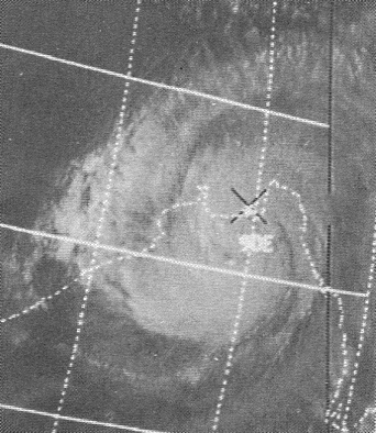
English: This ITOS 1 weather satellite image of the November 12, 1970 Bay of Bengal Tropical Cyclone was taken at 0956 UTC |
| Date | |
| Source | Mariners Weather Log, January 1971, pg. 19 |
| Author | NOAA |
| Camera location | | View this and other nearby images on: OpenStreetMap |
|---|
Licensing
[edit]
This image is in the public domain because it contains materials that originally came from the U.S. National Oceanic and Atmospheric Administration, taken or made as part of an employee's official duties.
|
Original upload log
[edit]
| Date/Time | Dimensions | User | Comment |
|---|---|---|---|
| 24 March 2013, 00:59:03 | 342 × 394 (152776 bytes) | Thegreatdr (talk · contribs) | User created page with UploadWizard |
File history
Click on a date/time to view the file as it appeared at that time.
| Date/Time | Thumbnail | Dimensions | User | Comment | |
|---|---|---|---|---|---|
| current | 17:40, 23 April 2016 | | 342 × 394 (150 KB) | BMacZero (talk | contribs) | remove noise |
| 23:04, 23 August 2014 |  | 342 × 394 (132 KB) | GifTagger (talk | contribs) | Bot: Converting file to superior PNG file. (Source: BayofBengalTCNov1219700956UTCITOS1.gif). This GIF was problematic due to non-greyscale color table. |
You cannot overwrite this file.
File usage on Commons
The following 5 pages use this file:
- Commons:WikiProject Aviation/recent uploads/2016 April 23
- File:13B 1970-11-12 0956Z.png (file redirect)
- File:BayofBengalTCNov1219700956UTCITOS1.gif (file redirect)
- File:BayofBengalTCNov1219700956UTCITOS1.png (file redirect)
- Category:1970 Bhola cyclone
File usage on other wikis
The following other wikis use this file:
- Usage on ar.wikipedia.org
- Usage on bn.wikipedia.org
- Usage on ca.wikipedia.org
- Usage on cs.wikipedia.org
- Usage on el.wikipedia.org
- Usage on en.wikipedia.org
- Usage on es.wikipedia.org
- Usage on eu.wikipedia.org
- Usage on fa.wikipedia.org
- Usage on fi.wikipedia.org
- Usage on fr.wikipedia.org
- Usage on ga.wikipedia.org
- Usage on he.wikipedia.org
- Usage on hr.wikipedia.org
- Usage on ml.wikipedia.org
- Usage on my.wikipedia.org
- Usage on oc.wikipedia.org
- Usage on pt.wikipedia.org
- Usage on ro.wikipedia.org
- Usage on tr.wikipedia.org
- Usage on ur.wikipedia.org
- Usage on vi.wikipedia.org
- Usage on www.wikidata.org
- Usage on zh-yue.wikipedia.org
- Usage on zh.wikipedia.org