File:Bay Area displacement ESA369788.jpg
Jump to navigation
Jump to search
Size of this preview: 799 × 345 pixels. Other resolutions: 320 × 138 pixels | 640 × 276 pixels | 1,024 × 442 pixels | 1,280 × 553 pixels | 2,560 × 1,106 pixels | 7,718 × 3,333 pixels.
Original file (7,718 × 3,333 pixels, file size: 15.51 MB, MIME type: image/jpeg)
Captions
Captions
Add a one-line explanation of what this file represents
Summary
[edit]
| Description |
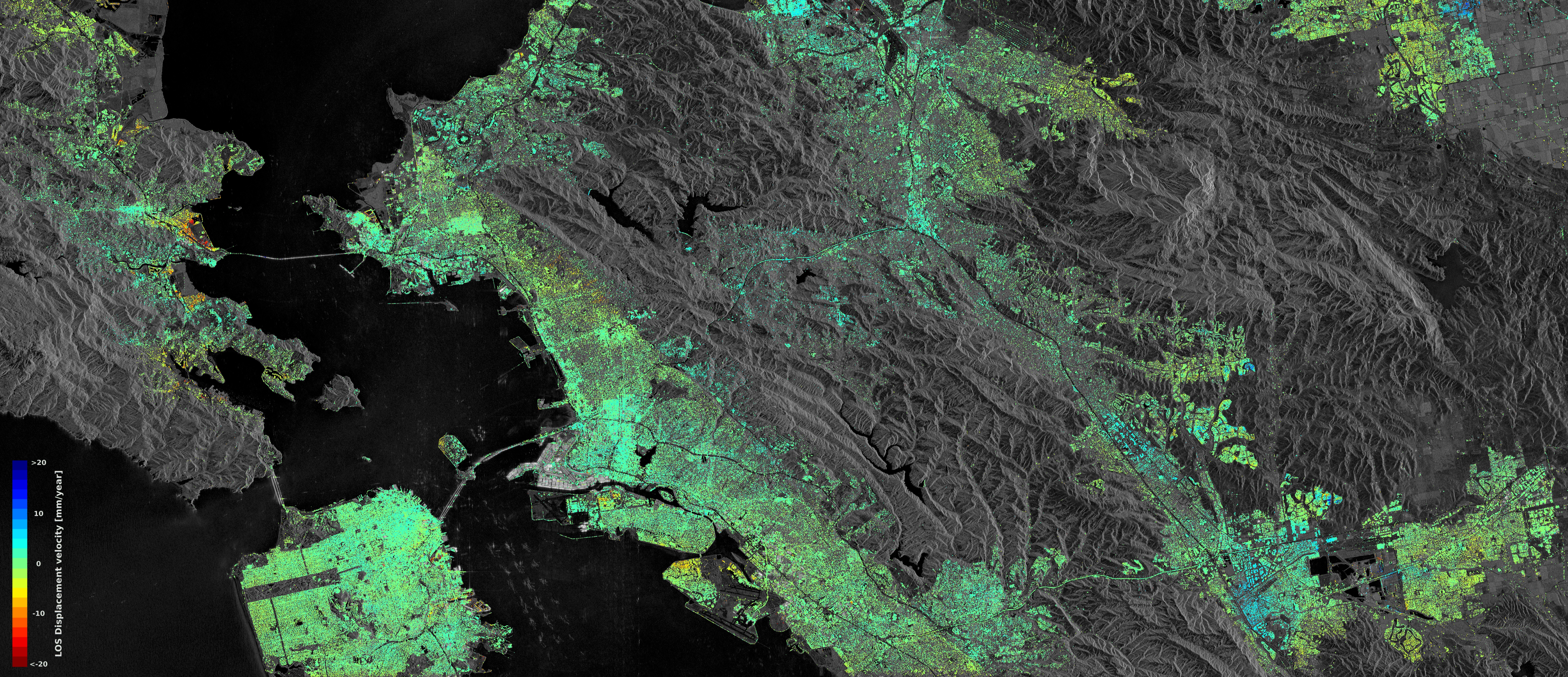
English: Sentinel-1 radar data show ground displacement of the San Francisco Bay Area. Hot spots are clearly observed, including the Hayward fault running north–south of the central-right side of the image. Subsidence of the newly reclaimed land in the San Rafael Bay on the left is also visible, while an uplift of land is visible in the lower right, possibly a result of a recovering groundwater level after a four-year long drought that ended in autumn 2015.
Read full article. |
| Date | |
| Source | http://www.esa.int/spaceinimages/Images/2016/11/Bay_Area_displacement |
| Author | European Space Agency |
| Permission (Reusing this file) |
Contains modified Copernicus Sentinel data (2015–16) / ESA SEOM INSARAP study / PPO.labs / Norut / NGU,CC BY-SA 3.0 IGO |
| Title | Bay Area displacement |
| System | Copernicus |
| Keywords | Radar; Synthetic Aperture Radar; Deformation |
| Location | California |
| Mission | Sentinel-1 |
| Activity | Observing the Earth |
Licensing
[edit]
This file is licensed under the Creative Commons Attribution-ShareAlike 3.0 IGO license.
- You are free:
- to share – to copy, distribute and transmit the work
- to remix – to adapt the work
- Under the following conditions:
- attribution – You must give appropriate credit, provide a link to the license, and indicate if changes were made. You may do so in any reasonable manner, but not in any way that suggests the licensor endorses you or your use.
- share alike – If you remix, transform, or build upon the material, you must distribute your contributions under the same or compatible license as the original.
File history
Click on a date/time to view the file as it appeared at that time.
| Date/Time | Thumbnail | Dimensions | User | Comment | |
|---|---|---|---|---|---|
| current | 15:28, 6 May 2017 | | 7,718 × 3,333 (15.51 MB) | Fæ (talk | contribs) | == {{int:filedesc}} == {{information | description = {{en|1=Sentinel-1 radar data show ground displacement of the San Francisco Bay Area. Hot spots are clearly observed, including the Hayward fault running north–south of the central-right side of the... |
You cannot overwrite this file.
File usage on Commons
The following page uses this file: