File:Bay-of-Piran maritime-boundary-dispute.svg
Jump to navigation
Jump to search

Size of this PNG preview of this SVG file: 644 × 600 pixels. Other resolutions: 258 × 240 pixels | 515 × 480 pixels | 824 × 768 pixels | 1,099 × 1,024 pixels | 2,199 × 2,048 pixels | 789 × 735 pixels.
Original file (SVG file, nominally 789 × 735 pixels, file size: 35 KB)
Captions
Captions
Add a one-line explanation of what this file represents
Summary[edit]
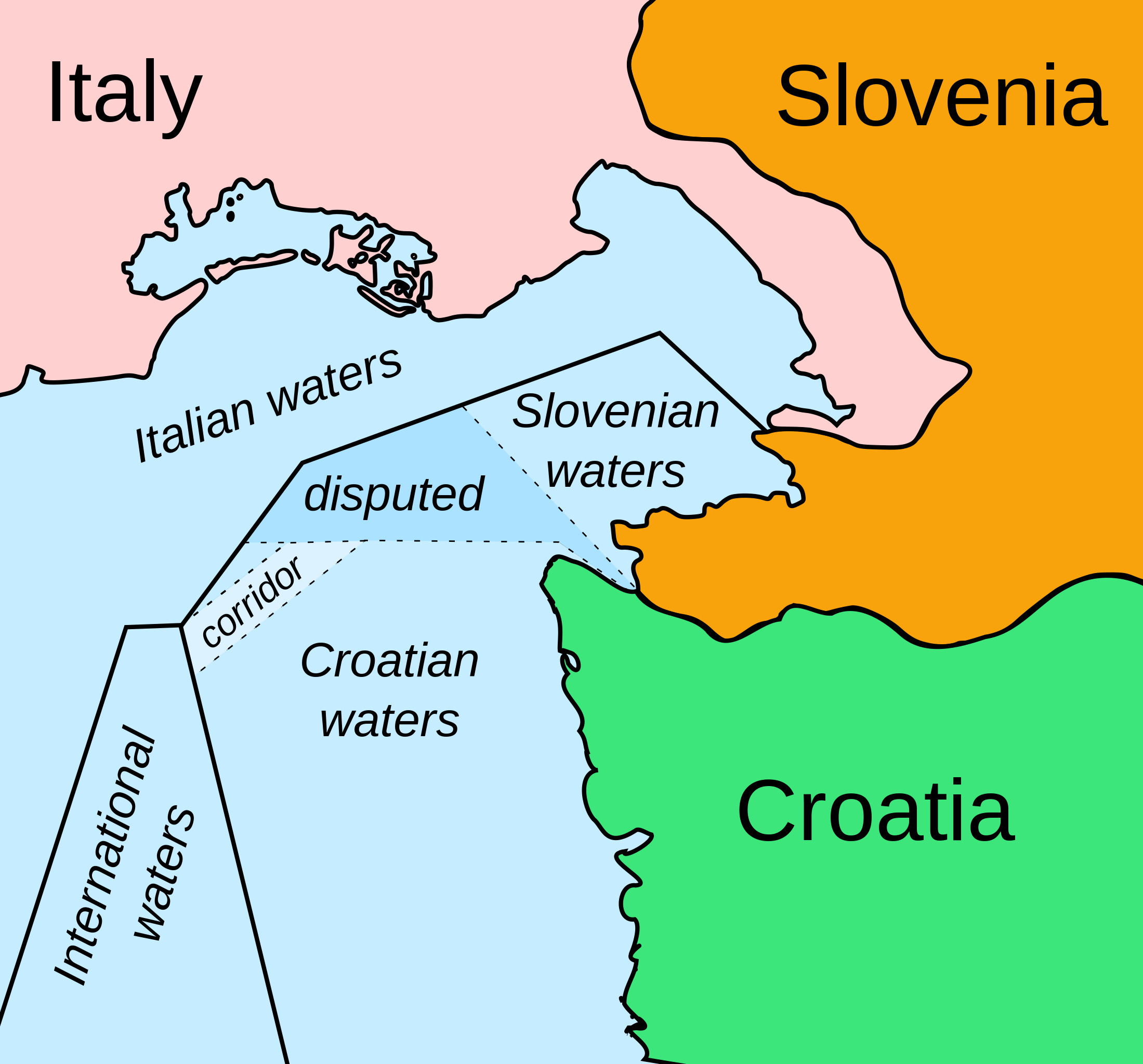
| Description | Map showing a proposed solution under the Drnovšek-Račan agreement to the diplomatic dispute on the maritime border between Slovenia and Croatia. The agreement was never ratified by either countries' parliaments. In 2017, the Permanent Court of Arbitration issued a ruling that fixes the border, although Croatia disputes it. | ||
| Date | (UTC) | ||
| Source | Bay-of-Piran maritime-boundary-dispute.jpg | ||
| Author | |||
| Other versions |
[]
|
||
| SVG development |
|


I, the copyright holder of this work, hereby publish it under the following licenses:
| This file is licensed under the Creative Commons Attribution-Share Alike 3.0 Unported license. | ||
| ||
| This licensing tag was added to this file as part of the GFDL licensing update. |

|
Permission is granted to copy, distribute and/or modify this document under the terms of the GNU Free Documentation License, Version 1.2 or any later version published by the Free Software Foundation; with no Invariant Sections, no Front-Cover Texts, and no Back-Cover Texts. A copy of the license is included in the section entitled GNU Free Documentation License. |
You may select the license of your choice.
Original upload log[edit]
This image is a derivative work of the following images:
- File:Bay-of-Piran_maritime-boundary-dispute.jpg licensed with Cc-by-sa-3.0-migrated, GFDL, PD-user
- 2007-01-08T14:17:47Z AnonMoos 709x600 (164071 Bytes) adding city names
- 2006-12-24T18:13:52Z AnonMoos 709x600 (159774 Bytes) deepening colors slightly
- 2006-12-14T14:00:38Z AnonMoos 709x600 (160124 Bytes) Map showing diplomatic dispute over Slovenia's desire to obtain a direct corridor from its own territorial waters to international waters, to avoid Slovenian ships having to sail through the territorial waters of any other co
File history
Click on a date/time to view the file as it appeared at that time.
| Date/Time | Thumbnail | Dimensions | User | Comment | |
|---|---|---|---|---|---|
| current | 01:01, 23 February 2011 | | 789 × 735 (35 KB) | Themightyquill (talk | contribs) | Added "corridor" label and calmed colours |
| 06:04, 18 February 2011 |  | 789 × 735 (34 KB) | Themightyquill (talk | contribs) | {{Information |Description=Map showing a diplomatic dispute resulting from Slovenia's desire to obtain a direct corridor from its own territorial waters to international waters, to avoid the necessity of Slovenian ships having to sail through the territor |
You cannot overwrite this file.
File usage on Commons
The following 27 pages use this file:
- User:Themightyquill
- File:Bay-of-Piran maritime-boundary-dispute-ar.png
- File:Bay-of-Piran maritime-boundary-dispute-br.svg
- File:Bay-of-Piran maritime-boundary-dispute-eo.svg
- File:Bay-of-Piran maritime-boundary-dispute-fr.svg
- File:Bay-of-Piran maritime-boundary-dispute-hr.svg
- File:Bay-of-Piran maritime-boundary-dispute-hu.svg
- File:Bay-of-Piran maritime-boundary-dispute-it.SVG
- File:Bay-of-Piran maritime-boundary-dispute-mk.SVG
- File:Bay-of-Piran maritime-boundary-dispute-ru.svg
- File:Bay-of-Piran maritime-boundary-dispute-sr.svg
- File:Bay-of-Piran maritime-boundary-dispute.SVG (file redirect)
- File:Bay-of-Piran maritime-boundary-dispute.svg
- File:Bay-of-Piran maritime-boundary-dispute-sr.svg
- File:Bay-of-Piran maritime-boundary-dispute-hr.svg
- File:Bay-of-Piran maritime-boundary-dispute-ar.png
- File:Bay-of-Piran maritime-boundary-dispute-mk.SVG
- File:Bay-of-Piran maritime-boundary-dispute-it.SVG
- Template:Other versions/Bay-of-Piran maritime-boundary-dispute
- File:Bay-of-Piran maritime-boundary-dispute-ru.svg
- File:Bay-of-Piran maritime-boundary-dispute-hu.svg
- File:Bay-of-Piran maritime-boundary-dispute-fr.svg
- File:Bay-of-Piran maritime-boundary-dispute-eo.svg
- File:Bay-of-Piran maritime-boundary-dispute-br.svg
- File:Bay-of-Piran maritime-boundary-dispute.jpg
- File:Bay-of-Piran maritime-boundary-dispute.svg
- Template:Other versions/Bay-of-Piran maritime-boundary-dispute
File usage on other wikis
The following other wikis use this file:
- Usage on ca.wikipedia.org
- Usage on cs.wikipedia.org
- Usage on de.wikipedia.org
- Usage on en.wikipedia.org
- Usage on es.wikipedia.org
- Usage on et.wikipedia.org
- Usage on gl.wikipedia.org
- Usage on ka.wikipedia.org
- Usage on mk.wikipedia.org
- Usage on nl.wikipedia.org
- Usage on pl.wikipedia.org
- Usage on pt.wikipedia.org
- Usage on sh.wikipedia.org
- Usage on sk.wikipedia.org
- Usage on sl.wikipedia.org
- Usage on uk.wikipedia.org