File:Battle of Brandywine in which the Americans were defeated - September the 11th, 1777 by General Sr. William Howe. LOC gm71000671.jpg
Jump to navigation
Jump to search

Size of this preview: 497 × 599 pixels. Other resolutions: 199 × 240 pixels | 398 × 480 pixels | 637 × 768 pixels | 850 × 1,024 pixels | 1,699 × 2,048 pixels | 7,488 × 9,025 pixels.
Original file (7,488 × 9,025 pixels, file size: 11.42 MB, MIME type: image/jpeg)
Captions
Captions
Add a one-line explanation of what this file represents
Summary
[edit]| Description |
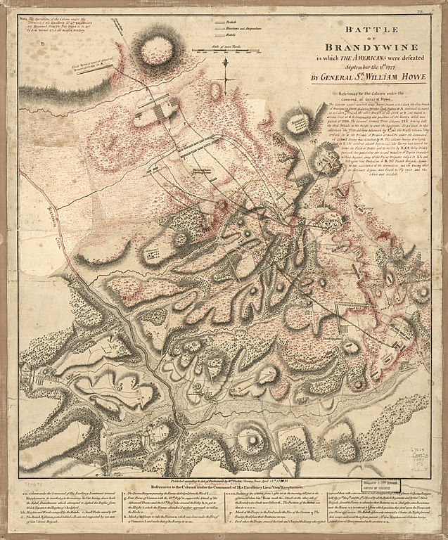
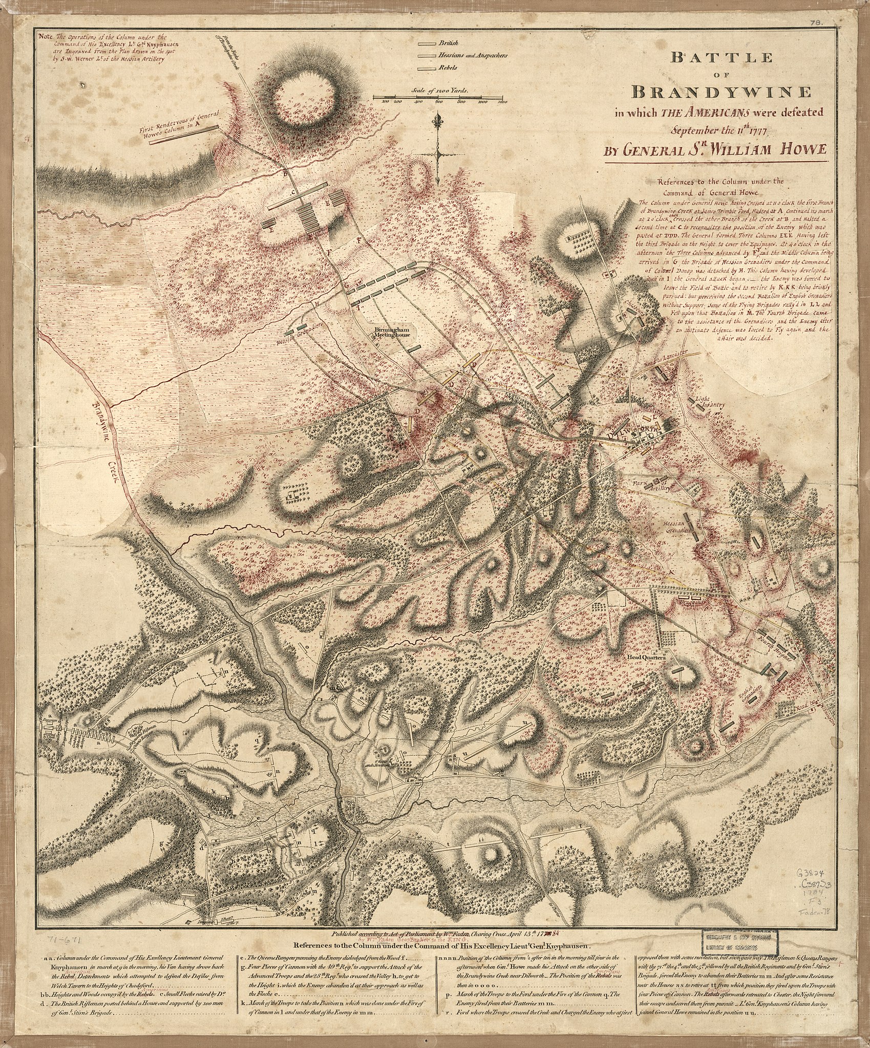
English: Scale ca. 1:15,300. Hand colored. Annotated in red ink on the author's Battle of Brandywine, 1778. Other changes have been made by erasure or by excision of parts and replacement of new paper. Prepared as engraver's copy for a new edition. "Note: The operations of the column under the command of His Excellency Lt. Gal. Knyphausen are engraved from the plan drawn on the spot by S. W. Werner, Lt. of the Hessian artillery." LC Maps of North America, 1750-1789, 1338 Available also through the Library of Congress Web site as a raster image. Vault AACR2: 100; 650/1 |
||
| Title | Battle of Brandywine in which the Americans were defeated : September the 11th, 1777 by General Sr. William Howe. | ||
| Shelf ID | G3824.C387S3 1784 .F3 | ||
| Date | |||
| Source | https://www.loc.gov/item/gm71000671/ | ||
| Author | Faden, William; Werner, S. W. | ||
| Permission (Reusing this file) |
|
||
| Other versions |
|
||
| Location | Pennsylvania · United States · Chadds Ford Region | ||
| Part of | Military Battles And Campaigns · American Memory · Catalog · Geography And Map Division · American Revolution And Its Era: Maps And Charts Of North America And The West Indies, 1750-1789 | ||
| Subject | Early Maps · Chadds Ford Region · Brandywine, Battle Of, Pa. · Pennsylvania · Chadds Ford Region (Pa.) · United States · Maps · Early Works To 1800 · Manuscript Maps |


Licensing
[edit]
|
This is a faithful photographic reproduction of a two-dimensional, public domain work of art. The work of art itself is in the public domain for the following reason:
The official position taken by the Wikimedia Foundation is that "faithful reproductions of two-dimensional public domain works of art are public domain".
This photographic reproduction is therefore also considered to be in the public domain in the United States. In other jurisdictions, re-use of this content may be restricted; see Reuse of PD-Art photographs for details. | ||||
File history
Click on a date/time to view the file as it appeared at that time.
| Date/Time | Thumbnail | Dimensions | User | Comment | |
|---|---|---|---|---|---|
| current | 09:34, 16 May 2018 | | 7,488 × 9,025 (11.42 MB) | Fæ (talk | contribs) | LOC Maps https://www.loc.gov/item/gm71000671/ #990 |
You cannot overwrite this file.
File usage on Commons
The following page uses this file: