File:BattleOfFortWashingtonMapBySauthier.jpg
Jump to navigation
Jump to search

Size of this preview: 330 × 600 pixels. Other resolutions: 132 × 240 pixels | 264 × 480 pixels | 422 × 768 pixels | 563 × 1,024 pixels | 2,528 × 4,595 pixels.
Original file (2,528 × 4,595 pixels, file size: 4.79 MB, MIME type: image/jpeg)
Captions
Captions
Add a one-line explanation of what this file represents
Summary[edit]
| Description |
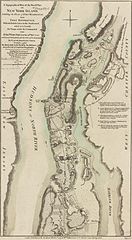
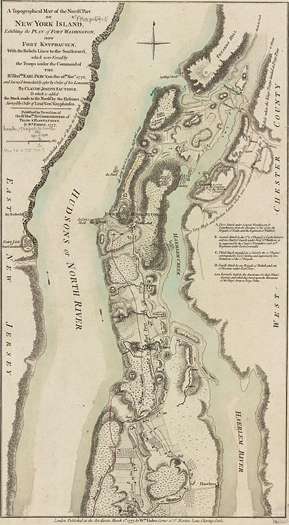
English: This map depicts the northern end of Manhattan, and the military fortifications in the area in 1776, during the American Revolutionary War. It has markings describing the military movements of the Battle of Fort Washington, fought November 16, 1776.
The map's caption reads: A Topographical Map of the Northn. Part of New York Island, Exhibiting the Plan of Fort Washington, now Fort Knyphausen, With the Rebels Lines to the Southward, which were forced by the Troops under the Command of the Rt. Honble. Earl Percy, on the 16th Novr. 1776, and Survey'd immediately after by Order of his Lordship, By Claude Joseph Sauthier. To which is added the Attack made to the Northd. by the Hessians Survey'd by Order of Lieutt. Genl. Knyphausen. Published by Permission of The Rt. Honble. the Commissioners of Trade & Plantations. By Wm. Faden, 1777. |
|||||||||||||||||||||||||||||||||||||||||
| Date | ||||||||||||||||||||||||||||||||||||||||||
| Source |
From the Boston Public Library Digital Map Collection: http://maps.bpl.org/details_10863/ |
|||||||||||||||||||||||||||||||||||||||||
| Author |
|
|||||||||||||||||||||||||||||||||||||||||
| Other versions |
 |
|||||||||||||||||||||||||||||||||||||||||
Licensing[edit]
This media file is in the public domain in the United States. This applies to U.S. works where the copyright has expired, often because its first publication occurred prior to January 1, 1929, and if not then due to lack of notice or renewal. See this page for further explanation.
|
 | |
 |
This image might not be in the public domain outside of the United States; this especially applies in the countries and areas that do not apply the rule of the shorter term for US works, such as Canada, Mainland China (not Hong Kong or Macao), Germany, Mexico, and Switzerland. The creator and year of publication are essential information and must be provided. See Wikipedia:Public domain and Wikipedia:Copyrights for more details.
|
|
This is a faithful photographic reproduction of a two-dimensional, public domain work of art. The work of art itself is in the public domain for the following reason:
The official position taken by the Wikimedia Foundation is that "faithful reproductions of two-dimensional public domain works of art are public domain".
This photographic reproduction is therefore also considered to be in the public domain in the United States. In other jurisdictions, re-use of this content may be restricted; see Reuse of PD-Art photographs for details. | ||||
File history
Click on a date/time to view the file as it appeared at that time.
| Date/Time | Thumbnail | Dimensions | User | Comment | |
|---|---|---|---|---|---|
| current | 19:27, 22 April 2009 | | 2,528 × 4,595 (4.79 MB) | Magicpiano (talk | contribs) | {{Information |Description={{en|1=This map depicts the northern end of w:Manhattan, and the military fortifications in the area in 1776, during the w:American Revolutionary War. It has markings describing the military movements of the [[w:Battl |
You cannot overwrite this file.
File usage on Commons
The following 2 pages use this file:
File usage on other wikis
The following other wikis use this file:
- Usage on en.wikipedia.org
- Usage on es.wikipedia.org
- Usage on fr.wikipedia.org
- Usage on it.wikipedia.org
- Usage on ja.wikipedia.org
- Usage on nl.wikipedia.org
- Usage on pt.wikipedia.org
- Usage on www.wikidata.org
Metadata
Categories:
- Maps by Claude Joseph Sauthier
- Maps by William Faden
- Battle of Fort Washington
- Maps of the history of New York (state)
- Military maps of the United States
- 1777 maps of New York (state)
- Maps of the New York and New Jersey Campaign
- Maps of battles of the American Revolutionary War
- Spuyten Duyvil Creek
- Old maps of Manhattan north of 155th Street
- Maps of the Hudson River