File:Bass Strait infrastructure.png
Jump to navigation
Jump to search
No higher resolution available.
Bass_Strait_infrastructure.png (500 × 467 pixels, file size: 191 KB, MIME type: image/png)
Captions
Captions
Add a one-line explanation of what this file represents
| Description |
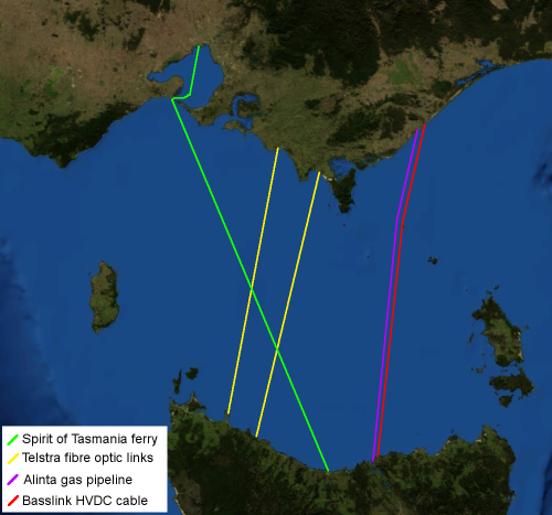
English: Map of Bass Strait including electrical, gas, communications and transport infrastructure.
Background imagery derived from NASA World Wind.
עברית: חיבורי תשתית עיקריים בין טסמניה ומדינת ויקטוריה |
| Date | 15 April 2006 (original upload date) |
| Source | Transferred from en.wikipedia to Commons by Yuval Y using CommonsHelper. |
| Author | Chuq at English Wikipedia |
Licensing
[edit]
| This image is in the public domain because it is a screenshot from NASA’s globe software World Wind using a public domain layer, such as Blue Marble, MODIS, Landsat, SRTM, USGS or GLOBE.
|
 |
| This work has been released into the public domain by its author, Chuq at English Wikipedia. This applies worldwide. In some countries this may not be legally possible; if so: Chuq grants anyone the right to use this work for any purpose, without any conditions, unless such conditions are required by law. |
Original upload log
[edit]
The original description page was here. All following user names refer to en.wikipedia.
- 2006-04-15 06:46 Chuq 500×467× (195974 bytes) Map of [[Bass Strait]] including electrical, gas, communications and transport infrastructure. Background imagery derived from [[NASA World Wind]].
File history
Click on a date/time to view the file as it appeared at that time.
| Date/Time | Thumbnail | Dimensions | User | Comment | |
|---|---|---|---|---|---|
| current | 12:49, 8 July 2009 | | 500 × 467 (191 KB) | File Upload Bot (Magnus Manske) (talk | contribs) | {{BotMoveToCommons|en.wikipedia|year={{subst:CURRENTYEAR}}|month={{subst:CURRENTMONTHNAME}}|day={{subst:CURRENTDAY}}}} {{Information |Description={{en|Map of en:Bass Strait including electrical, gas, communications and transport infrastructure. Ba |
You cannot overwrite this file.
File usage on Commons
There are no pages that use this file.
File usage on other wikis
The following other wikis use this file:
- Usage on en.wikipedia.org
- Usage on he.wikipedia.org
- Usage on hy.wikipedia.org
- Usage on ru.wikipedia.org