File:Barmby Tidal Barrage - geograph.org.uk - 577445.jpg
Jump to navigation
Jump to search
No higher resolution available.
Barmby_Tidal_Barrage_-_geograph.org.uk_-_577445.jpg (640 × 477 pixels, file size: 70 KB, MIME type: image/jpeg)
Captions
Captions
Add a one-line explanation of what this file represents
Summary
[edit]
| Description |
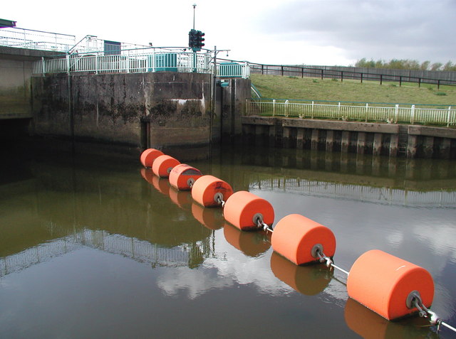
English: Barmby Tidal Barrage, Barmby on the Marsh, East Riding of Yorkshire, England. The north (River Derwent) side of Barmby Tidal Barrage, looking southwest towards the lock gates. The concrete barrage was built in 1975 where the River Derwent flows into the Ouse, as a flood prevention measure and to stop polluted water from the Ouse contaminating the Derwent, which is a source of drinking water. The lock allows pleasure craft to pass through. |
| Date | |
| Source | From geograph.org.uk |
| Author | Paul Glazzard |
| Permission (Reusing this file) |
Creative Commons Attribution Share-alike license 2.0 |
| Attribution (required by the license) | Paul Glazzard / Barmby Tidal Barrage / |
| Camera location | | View this and other nearby images on: OpenStreetMap |
|---|
_heading:225.00&language=en)
| Object location | | View this and other nearby images on: OpenStreetMap |
|---|
_heading:225.00&language=en)
Licensing
[edit]

|
This image was taken from the Geograph project collection. See this photograph's page on the Geograph website for the photographer's contact details. The copyright on this image is owned by Paul Glazzard and is licensed for reuse under the Creative Commons Attribution-ShareAlike 2.0 license.
|
This file is licensed under the Creative Commons Attribution-Share Alike 2.0 Generic license.
Attribution: Paul Glazzard
- You are free:
- to share – to copy, distribute and transmit the work
- to remix – to adapt the work
- Under the following conditions:
- attribution – You must give appropriate credit, provide a link to the license, and indicate if changes were made. You may do so in any reasonable manner, but not in any way that suggests the licensor endorses you or your use.
- share alike – If you remix, transform, or build upon the material, you must distribute your contributions under the same or compatible license as the original.
File history
Click on a date/time to view the file as it appeared at that time.
| Date/Time | Thumbnail | Dimensions | User | Comment | |
|---|---|---|---|---|---|
| current | 09:23, 6 February 2011 | | 640 × 477 (70 KB) | GeographBot (talk | contribs) | == {{int:filedesc}} == {{Information |description={{en|1=Barmby Tidal Barrage The north (River Derwent) side of Barmby Tidal Barrage, looking southwest towards the lock gates. The concrete barrage was built in 1975 where the River Derwent flows into the O |
You cannot overwrite this file.
File usage on Commons
There are no pages that use this file.