File:Banggai Islands Topography.png
Jump to navigation
Jump to search

Size of this preview: 638 × 600 pixels. Other resolutions: 255 × 240 pixels | 511 × 480 pixels | 817 × 768 pixels | 1,089 × 1,024 pixels | 1,999 × 1,879 pixels.
Original file (1,999 × 1,879 pixels, file size: 1.25 MB, MIME type: image/png)
Captions
Captions
Add a one-line explanation of what this file represents
Summary
[edit]
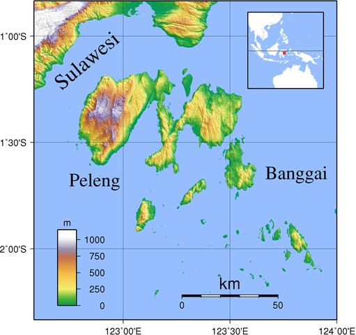
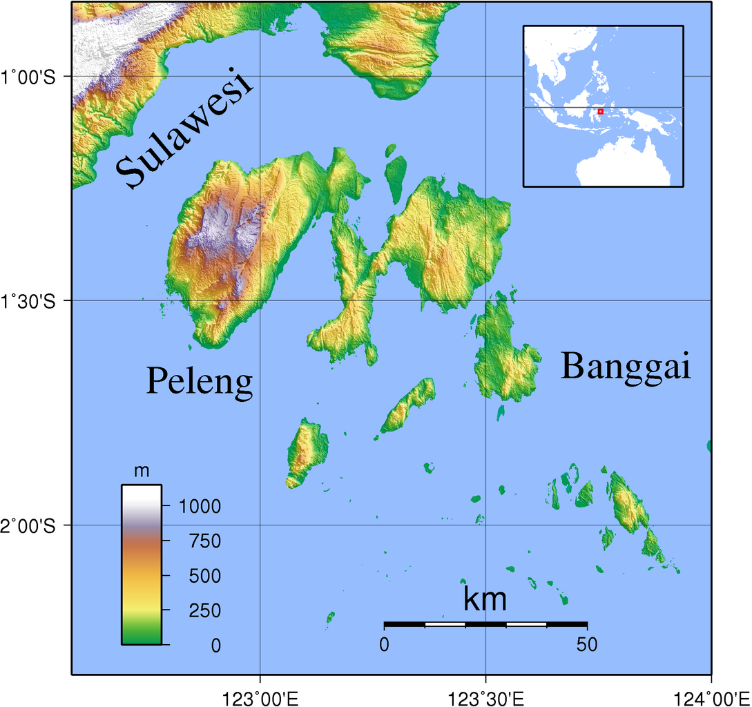
| Description | Topographic map of Banggai Islands, Indonesia. Created with GMT from SRTM data. The coastline data is pretty bad here, but since SRTM data of the region has a lot of spurious land masses, I had to use it nevertheless. |
| Date | |
| Source | Own work |
| Author | Sadalmelik |
Licensing
[edit]
I, the copyright holder of this work, hereby publish it under the following licenses:

|
Permission is granted to copy, distribute and/or modify this document under the terms of the GNU Free Documentation License, Version 1.2 or any later version published by the Free Software Foundation; with no Invariant Sections, no Front-Cover Texts, and no Back-Cover Texts. A copy of the license is included in the section entitled GNU Free Documentation License. |
This file is licensed under the Creative Commons Attribution-Share Alike 3.0 Unported, 2.5 Generic, 2.0 Generic and 1.0 Generic license.
- You are free:
- to share – to copy, distribute and transmit the work
- to remix – to adapt the work
- Under the following conditions:
- attribution – You must give appropriate credit, provide a link to the license, and indicate if changes were made. You may do so in any reasonable manner, but not in any way that suggests the licensor endorses you or your use.
- share alike – If you remix, transform, or build upon the material, you must distribute your contributions under the same or compatible license as the original.
You may select the license of your choice.
File history
Click on a date/time to view the file as it appeared at that time.
| Date/Time | Thumbnail | Dimensions | User | Comment | |
|---|---|---|---|---|---|
| current | 21:17, 11 September 2007 | | 1,999 × 1,879 (1.25 MB) | Sadalmelik (talk | contribs) | {{Information |Description=Topographic map of Banggai Islands, Indonesia. Created with GMT from SRTM data. The coastline data is pretty bad here, but since SRTM data of the region has a lot of spurious land masses, I had to use it nevertheless. |Source=s |
You cannot overwrite this file.
File usage on Commons
The following page uses this file:
File usage on other wikis
The following other wikis use this file:
- Usage on ar.wikipedia.org
- Usage on arz.wikipedia.org
- Usage on ceb.wikipedia.org
- Usage on de.wikipedia.org
- Usage on en.wikipedia.org
- Usage on es.wikipedia.org
- Usage on eu.wikipedia.org
- Usage on fi.wikipedia.org
- Usage on fr.wikipedia.org
- Usage on gl.wikipedia.org
- Usage on id.wikipedia.org
- Usage on it.wikipedia.org
- Usage on ja.wikipedia.org
- Usage on lt.wikipedia.org
- Usage on lv.wikipedia.org
- Usage on mrj.wikipedia.org
- Usage on nl.wikipedia.org
- Usage on pl.wikipedia.org
- Usage on pt.wikipedia.org
- Usage on ru.wikipedia.org
- Usage on sv.wikipedia.org
- Usage on ta.wikipedia.org
- Usage on uk.wikipedia.org
- Usage on vi.wikipedia.org
- Usage on www.wikidata.org
- Usage on wuu.wikipedia.org
- Usage on zh-yue.wikipedia.org
View more global usage of this file.