File:Baltische Stämme um 1200.png
Jump to navigation
Jump to search

Size of this preview: 544 × 599 pixels. Other resolutions: 218 × 240 pixels | 436 × 480 pixels | 697 × 768 pixels | 930 × 1,024 pixels | 1,980 × 2,180 pixels.
Original file (1,980 × 2,180 pixels, file size: 473 KB, MIME type: image/png)
Captions
Captions
Add a one-line explanation of what this file represents
Summary[edit]
| Description |
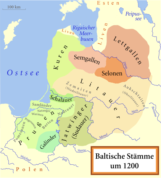
[] Català: Un mapa de les tribus bàltiques, cap al 1200 d.C. Els bàltics orientals es mostren en tons marrons mentre que els bàltics occidentals es mostren en verd. Els límits són aproximats. Aquest mapa utilitza una projecció de Mercator. Deutsch: Karte der baltischen Stämme um 1200. Ostbalten in Braun, Westbalten in Grün. Ungefähre Grenzen. English: A map of the Baltic Tribes, about 1200 AD. The Eastern Balts are shown in brown hues while the Western Balts are shown in green. The boundaries are approximate. This map uses a Mercator projection. Español: Mapa de las tribus bálticas, alrededor de 1200 d.C. Los bálticos orientales se muestran en tonos marrones, mientras que los bálticos occidentales están mostrados en verde. Las fronteras son aproximadas. Français : Une carte des peuples baltes vers 1200. Les Baltes orientaux sont représentés en marron, tandis que les Baltes occidentaux sont représentés en vert. Les frontières sont approximatives. Latviešu: Baltu cilšu apdzīvotās teritorijas aptuveni 12-13 gs. mijā. Robežas ir aptuvenas. Rietumbalti kartē iezīmēt zaļganos toņos, austrumbalti - brūnganos. Lietuvių: Baltų genčių teritorija apie 1200 metus. Vakarų baltų teritorija yra nuspalvinta žaliomis, rytų - rusvomis spalvomis. Teritorijos yra apytikslės. Magyar: A balti törzsek területei 1200 körül. A keleti-balt törzseket barnás, a nyugati-baltokat zöldes színek jelölik. Nederlands: De Baltische volkeren ca. 1200 AD. Oostbalten in bruin, Westbalten in groen. Grenzen zijn bij benadering. Polski: Mapa ukazuje plemiona Bałtyjskie, około 1200 n.e. Wschodni Bałtowie są w odcieniach brązu, zachodni - zieleni. Беларуская: Мапа балтыйскіх плямёнаў у канцы 12 — пачату 13 стагодзьдзяў. Тэрыторыі ўсходніх балтаў афарбаваныя ў карычневых адценьнях, у той жа час тэрыторыі заходніх балтаў афарбаваныя ў адценьні зялёнага колеру. Межы ўказаныя прыблізна. Русский: Карта балтийских племен в конце 12 – начале 13 веков. Территории восточных балтов окрашены в коричневых оттенках, в то время как территории западных балтов окрашены в оттенках зеленого цвета. Границы указаны приблизительно. Українська: Карта балтійських племен 1200 року. Території східних балтів фарбовані коричневими відтінтакми, а території західних балтів - зеленими. Межі народів вказані умовно. |
||||||||
| Date | |||||||||
| Source | Own work based on: Baltic Tribes c 1200.svg by MapMaster | ||||||||
| Author |
|
||||||||
| Permission (Reusing this file) |
I, the copyright holder of this work, hereby publish it under the following licenses:
You may select the license of your choice. |
||||||||
| Other versions |
[]
|
||||||||
| PNG development |
|

.svg&lang=ca)


.svg)

.svg)


Original upload log[edit]
This image is a derivative work of the following images:
- Baltic Tribes c 1200.svg licensed with Cc-by-sa-3.0-migrated, GFDL
- 2010-08-18T23:59:00Z Techman224 988x1088 (808115 Bytes) Removed Borders
- 2010-08-14T21:52:44Z Vearthy 988x1088 (807487 Bytes) ...
- 2010-08-14T21:49:45Z Vearthy 1003x1096 (808589 Bytes) sorry, wrong file...
- 2010-08-14T21:47:29Z Vearthy 1003x1096 (808589 Bytes) deleted unneeded contour, done some minor edits (paths)
- 2008-02-23T16:28:30Z Renata3 1003x1096 (808808 Bytes) change green colors as Curonians are west Balts
- 2007-01-28T00:57:36Z MapMaster 1003x1096 (808773 Bytes) another fix
- 2007-01-28T00:50:36Z MapMaster 1003x1096 (805196 Bytes) Minor fix
- 2007-01-17T01:38:57Z MapMaster 1003x1096 (806983 Bytes) Some adjustments based on Renata3's comments and further research
- 2007-01-15T02:20:25Z MapMaster 1003x1096 (782526 Bytes) Two small changes
- 2007-01-13T06:09:40Z MapMaster 1003x1096 (783265 Bytes) A map of the Baltic Tribes, about 1200 [[w:en:Common Era|CE]].
Uploaded with derivativeFX
File history
Click on a date/time to view the file as it appeared at that time.
| Date/Time | Thumbnail | Dimensions | User | Comment | |
|---|---|---|---|---|---|
| current | 09:10, 16 October 2022 | | 1,980 × 2,180 (473 KB) | Ulamm (talk | contribs) | {{Information |description={{Description/Baltic Tribes ca 1200 AD}} |date=2010-10-06 |source={{Based|Baltic_Tribes_c_1200.svg|by={{U|MapMaster||en}}}} |author=*{{AutVec|{{U|MapMaster||en}}|{{U|NordNordWest|NNW}}}} |permission={{self|Cc-by-sa-3.0-migrated|GFDL}} |other versions={{Other versions/Baltic Tribes ca 1200 AD}} |other fields={{Igen|I|+|<|r=translation|editor=NordNordWest|orig=Baltic_Tribes_c_1200.svg|s=m|u=NordNordWest}} }} == {{Original upload log}} == This image is a derivative wo... |
You cannot overwrite this file.
File usage on Commons
The following page uses this file:
File usage on other wikis
The following other wikis use this file:
- Usage on ca.wikipedia.org
- Usage on de.wikipedia.org
- Lettland
- Balten
- Baltische Sprachen
- Geschichte Lettlands
- Geschichte Litauens
- Žemaiten
- Düna
- Jatwinger
- Kuren
- Samogitien
- Selonische Sprache
- Deutschordensstaat
- Schalauer
- Sēlija
- Liste der baltischen Stämme
- Galinder
- Aukschtaitisch
- Lettgallen (Volk)
- Litauerkriege des Deutschen Ordens
- Prußen
- Skomand von Sudauen
- Schemaitisch
- Gräberfeld von Linkuhnen
- Liste der Kriege und Schlachten in Lettland