File:BalkhashPlaneTransaero.JPG
Jump to navigation
Jump to search

Size of this preview: 800 × 600 pixels. Other resolutions: 320 × 240 pixels | 640 × 480 pixels | 1,024 × 768 pixels | 1,280 × 960 pixels | 2,048 × 1,536 pixels.
Original file (2,048 × 1,536 pixels, file size: 325 KB, MIME type: image/jpeg)
Captions
Captions
Add a one-line explanation of what this file represents
Summary[edit]
| Description |
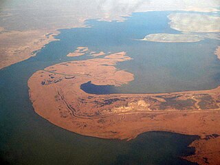
English: The center of Balkhash Lake as seen from an airplane.
Русский: Полуостров Сарыесик, разделяющий озеро Балхаш на две части, и пролив Узынарал. Апрель 2006 года, снимок сделан с борта самолёта Алма-Ата - Домодедово авиакомпании Трансаэро. |
| Date | |
| Source | Own work |
| Author | Ds02006 |
| Camera location | | View this and other nearby images on: OpenStreetMap |
|---|
Licensing[edit]
| I, the copyright holder of this work, release this work into the public domain. This applies worldwide. In some countries this may not be legally possible; if so: I grant anyone the right to use this work for any purpose, without any conditions, unless such conditions are required by law. |
File history
Click on a date/time to view the file as it appeared at that time.
| Date/Time | Thumbnail | Dimensions | User | Comment | |
|---|---|---|---|---|---|
| current | 10:45, 17 May 2009 | | 2,048 × 1,536 (325 KB) | Monfornot (talk | contribs) | improved colors |
| 10:16, 17 May 2009 |  | 2,048 × 1,536 (117 KB) | Ds02006 (talk | contribs) | {{Information |Description={{en|1=The center of Balkhash Lake as seen from a plane.}} {{ru|1=Полуостров Сарыесик, разделяющий озеро Балхаш на две части, и пролив Узынарал. Апрель 2006 |
You cannot overwrite this file.
File usage on Commons
There are no pages that use this file.
File usage on other wikis
The following other wikis use this file:
- Usage on ast.wikipedia.org
- Usage on az.wikipedia.org
- Usage on ba.wikipedia.org
- Usage on bg.wikipedia.org
- Usage on ca.wikipedia.org
- Usage on en.wikipedia.org
- Usage on es.wikipedia.org
- Usage on kbd.wikipedia.org
- Usage on kk.wikipedia.org
- Usage on kn.wikipedia.org
- Usage on ml.wikipedia.org
- Usage on oc.wikipedia.org
- Usage on ru.wikipedia.org
- Usage on sr.wikipedia.org
- Usage on uk.wikipedia.org