File:Balkan peninsula line.jpg
Jump to navigation
Jump to search
No higher resolution available.
Balkan_peninsula_line.jpg (558 × 530 pixels, file size: 169 KB, MIME type: image/jpeg)
Captions
Captions
Add a one-line explanation of what this file represents
Summary
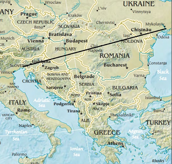
[edit]| Description | Map of the Balkan peninsula, showing the line stretching from the northernmost point of the Adriatic to the northernmost point of the Black Sea. Made from Europe map at The Central Intelligence Agency World Factbook, which is in the public domain. |
| Source | https://www.cia.gov/library/publications/the-world-factbook//graphics/ref_maps/physical/jpg/europe.jpg |
| Author | CIA |
| Other versions |
|
.jpg)
Licensing
[edit]This image is in the public domain because it contains materials that originally came from the United States Central Intelligence Agency's World Factbook.
|
 |

|
This map image could be re-created using vector graphics as an SVG file. This has several advantages; see Commons:Media for cleanup for more information. If an SVG form of this image is available, please upload it and afterwards replace this template with
{{vector version available|new image name}}.
It is recommended to name the SVG file “Balkan peninsula line.svg”—then the template Vector version available (or Vva) does not need the new image name parameter. |


File history
Click on a date/time to view the file as it appeared at that time.
| Date/Time | Thumbnail | Dimensions | User | Comment | |
|---|---|---|---|---|---|
| current | 12:27, 16 January 2014 | | 558 × 530 (169 KB) | Denniss (talk | contribs) | Reverted to version as of 22:51, 26 December 2013 |
| 21:21, 15 January 2014 |  | 348 × 382 (43 KB) | Ivan VA (talk | contribs) | stop vandalizing maps | |
| 22:51, 26 December 2013 |  | 558 × 530 (169 KB) | No More Cats (talk | contribs) | Please don't revert to outdated versions of maps | |
| 22:43, 26 December 2013 |  | 348 × 382 (43 KB) | Nikola Smolenski (talk | contribs) | Reverted to version as of 19:13, 3 November 2006 | |
| 16:06, 17 December 2013 |  | 558 × 530 (169 KB) | No More Cats (talk | contribs) | Map of the Balkan peninsula, showing the line stretching from the northernmost point of the Adriatic to the northernmost point of the Black Sea. Made from most recent map at [https://www.cia.gov/cia/publications/factbook/reference_maps/jpg/europe.jpg]. | |
| 19:13, 3 November 2006 |  | 348 × 382 (43 KB) | Nikola Smolenski (talk | contribs) | Map of the Balkan peninsula, showing the line stretching from the northernmost point of the Adriatic to the northernmost point of the Black Sea. Made from map at [https://www.cia.gov/cia/publications/factbook/reference_maps/jpg/europe.jpg]. |
You cannot overwrite this file.
File usage on Commons
There are no pages that use this file.