File:Bacia do rio Piracicaba (afluente do rio Doce) com municípios.png
Jump to navigation
Jump to search

Size of this preview: 800 × 566 pixels. Other resolutions: 320 × 226 pixels | 640 × 453 pixels | 1,024 × 724 pixels | 1,280 × 905 pixels | 2,560 × 1,810 pixels | 3,507 × 2,480 pixels.
Original file (3,507 × 2,480 pixels, file size: 627 KB, MIME type: image/png)
Captions
Captions
Add a one-line explanation of what this file represents
Summary[edit]
_com_munic%C3%ADpios.png&action=edit§ion=1)
| Description |
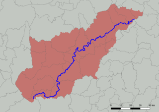
English: Map of the Piracicaba River basin (tributary of the Doce River), Minas Gerais, Brazil, with division into municipalities. Created with QGIS.
Português: Mapa da bacia do rio Piracicaba (afluente do rio Doce), em Minas Gerais, Brasil, com divisão em municípios. Criado em QGIS. |
| Date | |
| Source |
Own work; based on GIS data:
|
| Author | HVL |
Licensing[edit]
_com_munic%C3%ADpios.png&action=edit§ion=2)
I, the copyright holder of this work, hereby publish it under the following license:
This file is licensed under the Creative Commons Attribution 4.0 International license.
- You are free:
- to share – to copy, distribute and transmit the work
- to remix – to adapt the work
- Under the following conditions:
- attribution – You must give appropriate credit, provide a link to the license, and indicate if changes were made. You may do so in any reasonable manner, but not in any way that suggests the licensor endorses you or your use.
File history
Click on a date/time to view the file as it appeared at that time.
| Date/Time | Thumbnail | Dimensions | User | Comment | |
|---|---|---|---|---|---|
| current | 18:58, 15 August 2022 | | 3,507 × 2,480 (627 KB) | HVL (talk | contribs) | {{Information |description ={{en|1=Map of the Piracicaba River basin (tributary of the Doce River), Minas Gerais, Brazil, with division into municipalities. Created with QGIS.}} {{pt|1=Mapa da bacia do rio Piracicaba (afluente do rio Doce), em Minas Gerais, Brasil, com divisão em municípios. Criado em QGIS.}} |date =2022-08-15 |source ={{own}}; based on GIS data: * Instituto Pristino. ''Sistema WebGis de livre acesso ao banco de dados ambiental'' (in portuguese). Available i... |
You cannot overwrite this file.
File usage on Commons
The following page uses this file:
File usage on other wikis
The following other wikis use this file:
- Usage on pt.wikipedia.org
- Usage on www.wikidata.org
_com_municípios.png&oldid=814677005)