File:Bab al-Mandab Strait.jpg

Original file (4,491 × 2,520 pixels, file size: 4.78 MB, MIME type: image/jpeg)
Captions
Captions
Summary
[edit]
| Description |
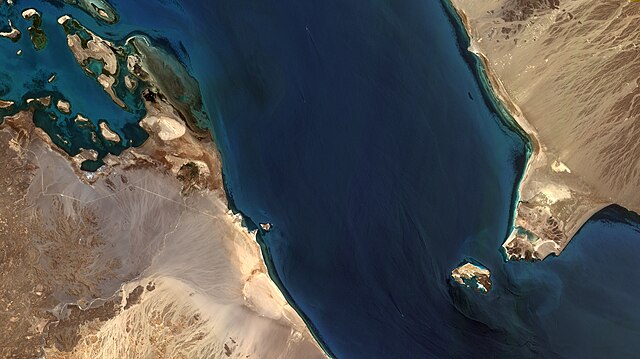
English: Estreito Babelmândebe, que separa a Ásia da África, conectando o Mar Vermelho ao Oceano Índico, através do Golfo de Adém / Bab al-Mandab Strait, located between Yemen on the Arabian Peninsula, on the right, and Djibouti and Eritrea in the Horn of Africa, to the left. It connects the Red Sea to the Gulf of Aden.
A pequena Ilha de Doumeira, à esq. do centro da imagem, marca a fronteira do Djibuti, ao Sul, com a Eritréia, ao Norte. Do outro lado do estreito está a ilha de Perim, no Iêmen / Little Doumeira Island, to the left of image center, is at Djibouti/Eritrea border by the sea. To the right is Perim Island, Yemen. Imagem / Image CBERS4 MUX Estreito Babelmândebe Coordenadas do centro da imagem / Image center: 12°47'19.1"N 43°15'40.4"E Data / Date: 04-06-2018 / 2018-04-06 RGB 765 (cor verdadeira / true color) Cena / Scene: 070 / 086 Autor / Author: Oton Barros (DSR/OBT/INPE) Imagem em HD / HD Image Visite-nos / Visit us: www.dsr.inpe.br |
| Date | |
| Source | https://www.flickr.com/photos/153282474@N02/42574640712/ |
| Author | Coordenação-Geral de Observação da Terra/INPE |
Licensing
[edit]
- You are free:
- to share – to copy, distribute and transmit the work
- to remix – to adapt the work
- Under the following conditions:
- attribution – You must give appropriate credit, provide a link to the license, and indicate if changes were made. You may do so in any reasonable manner, but not in any way that suggests the licensor endorses you or your use.
- share alike – If you remix, transform, or build upon the material, you must distribute your contributions under the same or compatible license as the original.
| This image was originally posted to Flickr by Coordenação-Geral de Observação da Terra/INPE at https://flickr.com/photos/153282474@N02/42574640712. It was reviewed on 9 April 2020 by FlickreviewR 2 and was confirmed to be licensed under the terms of the cc-by-sa-2.0. |
File history
Click on a date/time to view the file as it appeared at that time.
| Date/Time | Thumbnail | Dimensions | User | Comment | |
|---|---|---|---|---|---|
| current | 10:15, 9 April 2020 | | 4,491 × 2,520 (4.78 MB) | Jo-Jo Eumerus (talk | contribs) | Uploaded a work by Coordenação-Geral de Observação da Terra/INPE from https://www.flickr.com/photos/153282474@N02/42574640712/ with UploadWizard |
You cannot overwrite this file.
File usage on Commons
The following 2 pages use this file:
.jpg&redirect=no)