File:Azorestriple3d.png
Jump to navigation
Jump to search

Size of this preview: 800 × 478 pixels. Other resolutions: 320 × 191 pixels | 640 × 382 pixels | 1,020 × 609 pixels.
Original file (1,020 × 609 pixels, file size: 369 KB, MIME type: image/png)
Captions
Captions
Add a one-line explanation of what this file represents
Summary
[edit]
| Description |
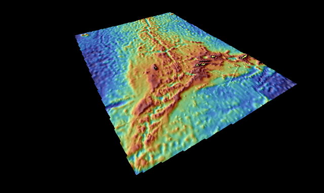
English: The Azores Triple Junction. Made by means of SAGA GIS from etopo1 bathymetry. Left=35W, right=25W, front=35N, back=45N, width=910km, back-front=1140km. Note the Pico Fracture Zone to the left and the East Azores Fracture Zone to the right. Some islands of the Azores are marked in yellow. |
| Date | |
| Source | NOAA, ETOPO1, GPLATES |
| Author | Pimvantend |
Licensing
[edit]
I, the copyright holder of this work, hereby publish it under the following license:
This file is licensed under the Creative Commons Attribution-Share Alike 3.0 Unported license.
- You are free:
- to share – to copy, distribute and transmit the work
- to remix – to adapt the work
- Under the following conditions:
- attribution – You must give appropriate credit, provide a link to the license, and indicate if changes were made. You may do so in any reasonable manner, but not in any way that suggests the licensor endorses you or your use.
- share alike – If you remix, transform, or build upon the material, you must distribute your contributions under the same or compatible license as the original.
File history
Click on a date/time to view the file as it appeared at that time.
| Date/Time | Thumbnail | Dimensions | User | Comment | |
|---|---|---|---|---|---|
| current | 18:32, 6 December 2011 | | 1,020 × 609 (369 KB) | Pimvantend (talk | contribs) | {{Information |Description ={{en|1=The Azores Triple Junction. Made by means of SAGA GIS from [http://ngdc.noaa.gov/mgg/global/global.html etopo1] bathymetry. Left=35W, right=25W, front |
You cannot overwrite this file.
File usage on Commons
There are no pages that use this file.
File usage on other wikis
The following other wikis use this file:
- Usage on cs.wikipedia.org
- Usage on en.wikipedia.org
- Usage on es.wikipedia.org
- Usage on eu.wikipedia.org
- Usage on fr.wikipedia.org
- Usage on hu.wikipedia.org
- Usage on it.wikipedia.org
- Usage on la.wikipedia.org
- Usage on pt.wikipedia.org
- Usage on uk.wikipedia.org
- Usage on www.wikidata.org
- Usage on zh.wikipedia.org