File:Awasi SA - 淡路SA 上り - panoramio.jpg
Jump to navigation
Jump to search

Size of this preview: 800 × 210 pixels. Other resolutions: 320 × 84 pixels | 640 × 168 pixels | 1,024 × 268 pixels | 1,280 × 335 pixels | 6,109 × 1,600 pixels.
Original file (6,109 × 1,600 pixels, file size: 917 KB, MIME type: image/jpeg)
Captions
Captions
Add a one-line explanation of what this file represents
Summary[edit]
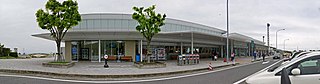
| Description | Awasi SA / 淡路SA 上り | ||
| Date | Taken on 7 May 2016 | ||
| Source | https://web.archive.org/web/20161103080434/http://www.panoramio.com/photo/130875425 | ||
| Author | z tanuki | ||
| Permission (Reusing this file) |
This file is licensed under the Creative Commons Attribution 3.0 Unported license. Attribution: z tanuki
|
||
| Panoramio Tags | Awaji, 2016, 兵庫県, 日本, 淡路市 |
| Camera location | | View this and other nearby images on: OpenStreetMap |
|---|
File history
Click on a date/time to view the file as it appeared at that time.
| Date/Time | Thumbnail | Dimensions | User | Comment | |
|---|---|---|---|---|---|
| current | 00:35, 10 July 2017 | 6,109 × 1,600 (917 KB) | Panoramio upload bot (talk | contribs) | == {{int:filedesc}} == {{Information |description=Awasi SA / 淡路SA 上り |date={{Taken on|2016-05-07}} |source=http://www.panoramio.com/photo/130875425 |author=[http://www.panoramio.com/user/238971?with_photo_id=130875425 z tanuki] |permission=... |
You cannot overwrite this file.
File usage on Commons
There are no pages that use this file.