File:Australian crater ESA396041.jpg

Original file (10,980 × 6,176 pixels, file size: 7.76 MB, MIME type: image/jpeg)
Captions
Captions
Summary[edit]
| Description |
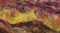
English: For Asteroid Day, the Copernicus Sentinel-2A satellite takes us over the Gosses Bluff crater in the Northern Territory of Australia. The crater is visible in the left centre of the image and it is about 22 km in diameter. It was most likely formed 140 million years ago by the impact of a large comet or meteorite slamming into the surface of Earth.
This false-colour image shows an extremely dry area with some vegetation visible in reddish colours along the rivers and lakes. The intense colours of the image represent the mineral composition of the land surface, which is clearly visible owing to the lack of vegetation. Azurite is one of the minerals mined here. A series of low hills and drainage structures can be seen in the lower part of the image, a result of erosion over the years. The West MacDonell Ranges can be seen in the upper section of the image and part of the Petermann Ranges are shown in the lower section. The crater is around 200 km west of Alice Springs, famous for being the gateway to the Red Centre, Australia’s interior desert region. Asteroid Daybrings people from around the world together to learn about asteroids, the impact hazard they may pose, and what we can do to protect our planet, families, communities, and future generations from asteroid impacts. It takes place on 30 June each year, which is the anniversary of the largest asteroid impact in recent history, the 1908 Tunguska event in Siberia. This year, ESA is co-hosting a live webcast with the European Southern Observatory packed with expert interviews, news on some of the most recent asteroid science results, and the truth about the dinosaurs. Watch 30 June at 13:00 CEST viawww.esa.int/asteroidday. This image, which was captured on 4 February 2016, is also featured on theEarth from Space video programme. |
| Date | |
| Source | http://www.esa.int/spaceinimages/Images/2018/06/Australian_crater |
| Author | European Space Agency |
| Permission (Reusing this file) |
contains modified Copernicus Sentinel data (2016), processed by ESA,CC BY-SA 3.0 IGO |
| Other versions |
|
| Title | Australian crater |
| System | Copernicus |
| Set | Earth observation image of the week |
| Mission | Sentinel-2 |
| Activity | Observing the Earth |
Licensing[edit]
- You are free:
- to share – to copy, distribute and transmit the work
- to remix – to adapt the work
- Under the following conditions:
- attribution – You must give appropriate credit, provide a link to the license, and indicate if changes were made. You may do so in any reasonable manner, but not in any way that suggests the licensor endorses you or your use.
- share alike – If you remix, transform, or build upon the material, you must distribute your contributions under the same or compatible license as the original.

|
This image contains data from a satellite in the Copernicus Programme, such as Sentinel-1, Sentinel-2 or Sentinel-3. Attribution is required when using this image.
Attribution: Contains modified Copernicus Sentinel data {{{year}}}
The use of Copernicus Sentinel Data is regulated under EU law (Commission Delegated Regulation (EU) No 1159/2013 and Regulation (EU) No 377/2014). Relevant excerpts:
Free access shall be given to GMES dedicated data [...] made available through GMES dissemination platforms [...].
Access to GMES dedicated data [...] shall be given for the purpose of the following use in so far as it is lawful:
GMES dedicated data [...] may be used worldwide without limitations in time.
GMES dedicated data and GMES service information are provided to users without any express or implied warranty, including as regards quality and suitability for any purpose. |
File history
Click on a date/time to view the file as it appeared at that time.
| Date/Time | Thumbnail | Dimensions | User | Comment | |
|---|---|---|---|---|---|
| current | 15:57, 29 June 2018 | | 10,980 × 6,176 (7.76 MB) | Fæ (talk | contribs) | European Space Agency, Id 396041, http://www.esa.int/spaceinimages/Images/2018/06/Australian_crater, User:Fæ/Project_list/ESA |
You cannot overwrite this file.
File usage on Commons
The following page uses this file: