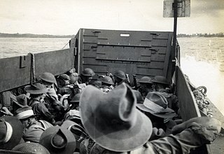
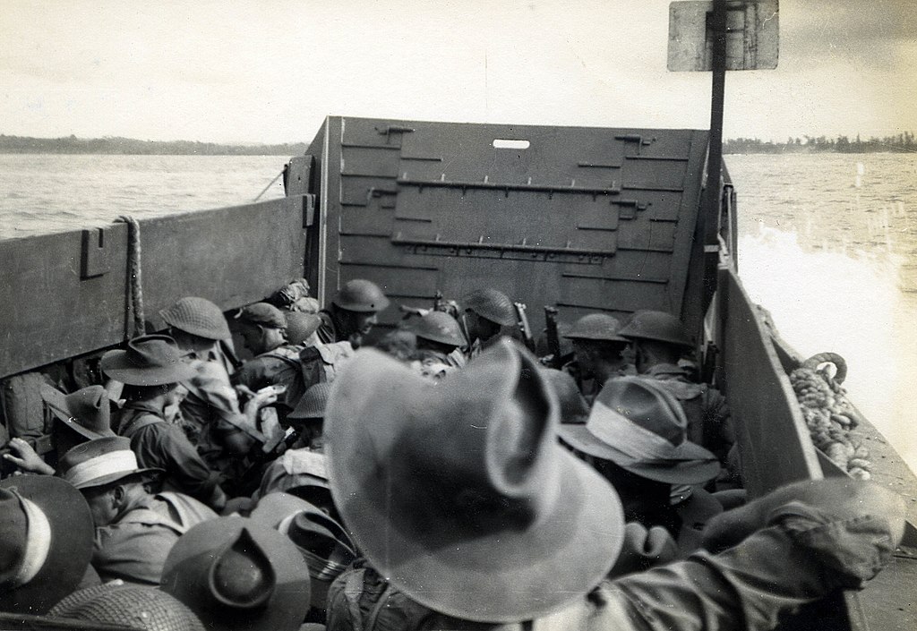
File:Aussie soldiers landing, Brunei Bay, 10 June 1945.jpg

Original file (3,592 × 2,472 pixels, file size: 773 KB, MIME type: image/jpeg)
Captions
Captions
Summary[edit]
| Description |
English: Notes: Jack Proctor is the coxswain and photographer. At the landings on Tarakan in June 1945, Jack drove a landing barge, "I always tried to get the men as near to the beach as I could so they didn't have to wade too far, but that meant we also came under enemy fire, other barges would drop the men early and clear off!", he said in an oral history interview a year before his death. He was later attached to US forces in the Philippines and witnessed troop evacuations from New Guinea.
The Battle of North Borneo took place during the Second World War between Allied and Japanese forces. Part of the wider Borneo campaign of the Pacific War, it was fought between 10 June and 15 August 1945 in North Borneo (later known as Sabah). The battle involved a series of amphibious landings by Australian forces on various points on the mainland around Brunei Bay and upon islands situated around the bay. Japanese opposition to the landings was sporadic initially, although as the campaign progressed a number of considerable clashes occurred and both sides suffered relatively significant casualties. Ultimately, however, the Australians were successful in seizing control of the region, although to a large extent the strategic gains that possession of North Borneo provided the Allies with were ultimately negated by the sudden conclusion of the war in August 1945. Format: B&W Photograph Licensing: Attribution, share alike, creative commons. Repository: Blue Mountains City Library www.bmcc.nsw.gov.au/library/ Part of: Local Studies Digital Collection - Proctor Album Provenance: Jack Proctor Links: en.wikipedia.org/wiki/Landing_Craft_Assault en.wikipedia.org/wiki/Battle_of_North_Borneo |
| Date | |
| Source | https://www.flickr.com/photos/blue_mountains_library_-_local_studies/8691027557/ |
| Author | Blue Mountains Library, Local Studies |
| Camera location | | View this and other nearby images on: OpenStreetMap |
|---|
Licensing[edit]
- You are free:
- to share – to copy, distribute and transmit the work
- to remix – to adapt the work
- Under the following conditions:
- attribution – You must give appropriate credit, provide a link to the license, and indicate if changes were made. You may do so in any reasonable manner, but not in any way that suggests the licensor endorses you or your use.
- share alike – If you remix, transform, or build upon the material, you must distribute your contributions under the same or compatible license as the original.
| This image was originally posted to Flickr by Blue Mountains Library, Local Studies at https://flickr.com/photos/26602074@N06/8691027557. It was reviewed on 21 April 2022 by FlickreviewR 2 and was confirmed to be licensed under the terms of the cc-by-sa-2.0. |
File history
Click on a date/time to view the file as it appeared at that time.
| Date/Time | Thumbnail | Dimensions | User | Comment | |
|---|---|---|---|---|---|
| current | 18:14, 21 April 2022 | | 3,592 × 2,472 (773 KB) | DeltaSquad833 (talk | contribs) | Uploaded a work by Blue Mountains Library, Local Studies from https://www.flickr.com/photos/blue_mountains_library_-_local_studies/8691027557/ with UploadWizard |
You cannot overwrite this file.
File usage on Commons
There are no pages that use this file.