File:Auckland Rail Network.png
Jump to navigation
Jump to search

Size of this preview: 800 × 240 pixels. Other resolutions: 640 × 192 pixels | 1,818 × 545 pixels.
Original file (1,818 × 545 pixels, file size: 439 KB, MIME type: image/png)
Captions
Captions
Add a one-line explanation of what this file represents
Summary
[edit]
| Description |
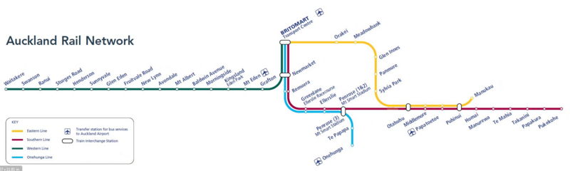
English: The current rail network map of Auckland from 12 March 2017 |
| Date | |
| Source | Auckland Transport |
| Author | Auckland Transport |
Licensing
[edit]
This file is licensed under the Creative Commons Attribution 3.0 Unported license.
- You are free:
- to share – to copy, distribute and transmit the work
- to remix – to adapt the work
- Under the following conditions:
- attribution – You must give appropriate credit, provide a link to the license, and indicate if changes were made. You may do so in any reasonable manner, but not in any way that suggests the licensor endorses you or your use.
File history
Click on a date/time to view the file as it appeared at that time.
| Date/Time | Thumbnail | Dimensions | User | Comment | |
|---|---|---|---|---|---|
| current | 01:25, 17 March 2017 | 1,818 × 545 (439 KB) | Akld guy (talk | contribs) | Removed Westfield station. Removed all fare stage information because Auckland now has fare zones with some zone overlap areas. | |
| 08:32, 12 December 2014 | 1,818 × 545 (493 KB) | Screwdriver10 (talk | contribs) | Reverted to version as of 08:28, 12 December 2014 | ||
| 08:30, 12 December 2014 | 1,818 × 545 (493 KB) | Screwdriver10 (talk | contribs) | 2014 version of rail network | ||
| 08:28, 12 December 2014 | 1,818 × 545 (493 KB) | Screwdriver10 (talk | contribs) | 2014 version of rail network | ||
| 08:08, 14 July 2011 | 1,261 × 256 (33 KB) | Ksoo012 (talk | contribs) |
You cannot overwrite this file.
File usage on Commons
The following 4 pages use this file:
File usage on other wikis
The following other wikis use this file:
- Usage on en.wikipedia.org
- Usage on en.wikivoyage.org
- Usage on pl.wikivoyage.org