File:Atmospheric Circulation effect of an expanding tropics.png
Original file (4,096 × 5,321 pixels, file size: 1.47 MB, MIME type: image/png)
Captions
Captions
Summary[edit]
| Description |
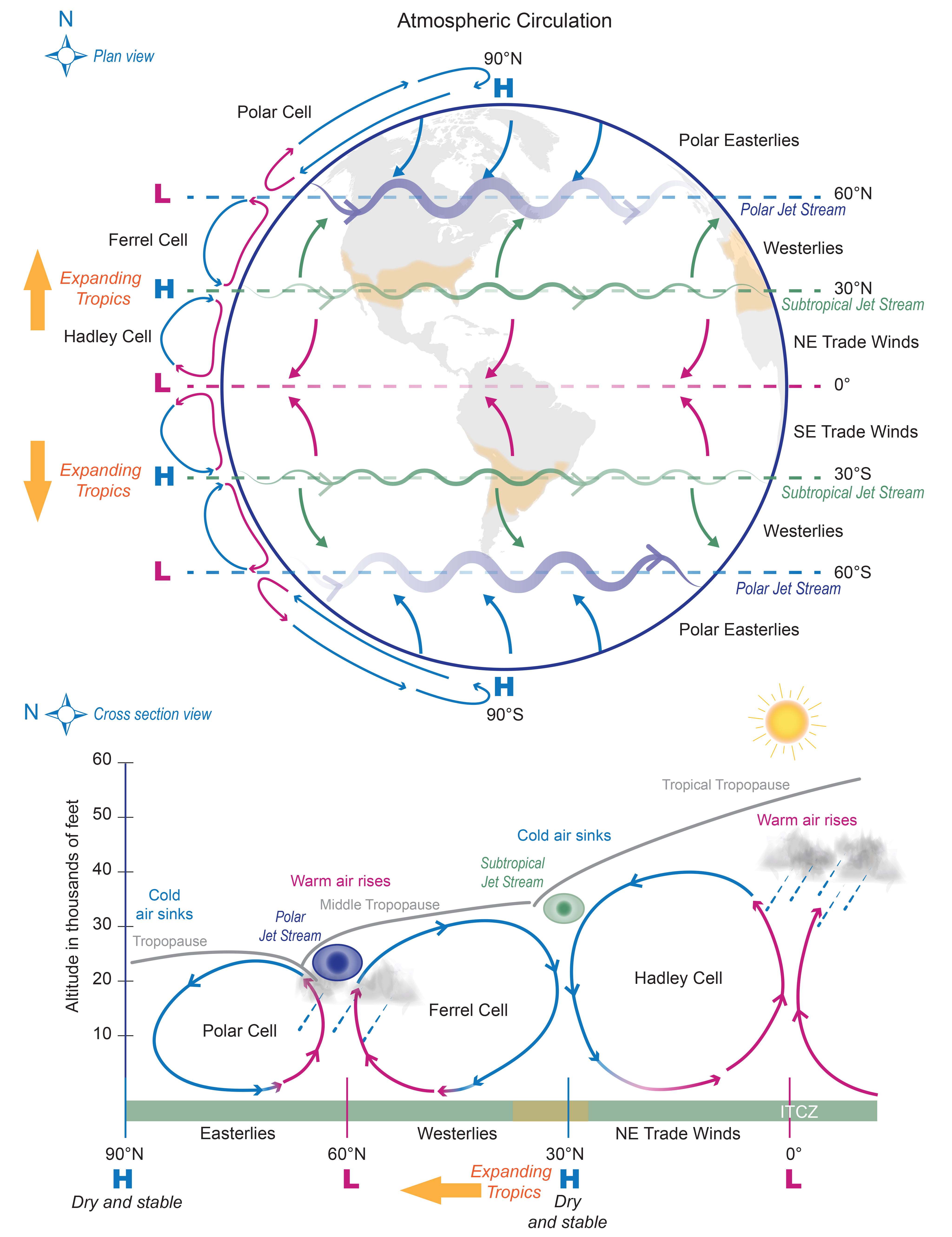
English: Caption: (top) Plan and (bottom) cross-section schematic view representations of the general circulation of the atmosphere. Three main circulations exist between the equator and poles due to solar heating and Earth’s rotation: 1) Hadley cell – Low-latitude air moves toward the equator. Due to solar heating, air near the equator rises vertically and moves poleward in the upper atmosphere. 2) Ferrel cell – A midlatitude mean atmospheric circulation cell. In this cell, the air flows poleward and eastward near the surface and equatorward and westward at higher levels. 3) Polar cell – Air rises, diverges, and travels toward the poles. Once over the poles, the air sinks, forming the polar highs. At the surface, air diverges outward from the polar highs. Surface winds in the polar cell are easterly (polar easterlies). A high pressure band is located at about 30° N/S latitude, leading to dry/hot weather due to descending air motion (subtropical dry zones are indicated in orange in the schematic views). Expanding tropics (indicted by orange arrows) are associated with a poleward shift of the subtropical dry zones. A low pressure band is found at 50°–60° N/S, with rainy and stormy weather in relation to the polar jet stream bands of strong westerly wind in the upper levels of the atmosphere. |
| Date | |
| Source |
The source for the diagram given in the report is U.S. Global Change Research Program: Climate Science Special Report, Fourth National Climate Assessment (NCA4), Volume I, chapter 5.1. https://science2017.globalchange.gov/ |
| Author |
This figures, “Atmospheric Circulation”, was provided by Judith Perlwitz. The original figure is found in: Panel #1: NWS, cited 2016: Global Circulations in NWS Jet Stream: An Online School for Weather. National Weather Service. [Available online at http://www.srh.noaa.gov/jetstream/global/circ.html]. The figure version presented here was adapted from the original as follows: The figure was adapted by adding content. This includes descriptive text of the circulation features (Polar Cell, Ferrell Cell, Hadley Cell, Polar easterlies, westerlies trade winds) , indicating the subtropical climate zones (orange shading in the map), and indicate by orange arrow the effect of an expanding tropics. Panel #2: NWS, cited 2016: Global Circulations in NWS Jet Stream: An Online School for Weather. National Weather Service. [Available online at http://www.srh.noaa.gov/jetstream/global/jet.html] The figure version presented here was adapted from the original as follows: The figure was adapted by adding content. This includes descriptive text (cold air sinks, warm air rises, Easterlies, Westerlies, NE Trade winds , regions of high (H) and low (L) pressure, and dry and stable regions). In addition subtropical climate latitude band is indicated in orange, and orange arrow indicates the effect of an expanding tropics. |
Licensing[edit]
This image is in the public domain because it contains materials that originally came from the U.S. National Oceanic and Atmospheric Administration, taken or made as part of an employee's official duties.
|
File history
Click on a date/time to view the file as it appeared at that time.
| Date/Time | Thumbnail | Dimensions | User | Comment | |
|---|---|---|---|---|---|
| current | 13:39, 21 May 2018 | | 4,096 × 5,321 (1.47 MB) | Frankemann (talk | contribs) | User created page with UploadWizard |
You cannot overwrite this file.
File usage on Commons
There are no pages that use this file.
File usage on other wikis
The following other wikis use this file:
- Usage on ca.wikipedia.org
- Usage on en.wikipedia.org
- Usage on en.wikibooks.org
- Usage on eu.wikipedia.org
- Usage on no.wikipedia.org