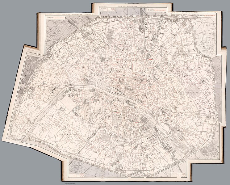
File:Atlas municipal des vingt arrondissements de la ville de Paris (13430019).jpg
From Wikimedia Commons, the free media repository
Jump to navigation
Jump to search

Size of this preview: 745 × 599 pixels. Other resolutions: 299 × 240 pixels | 597 × 480 pixels | 955 × 768 pixels | 1,273 × 1,024 pixels | 2,546 × 2,048 pixels | 31,291 × 25,168 pixels.
Original file (31,291 × 25,168 pixels, file size: 185.74 MB, MIME type: image/jpeg)
File information
Structured data
Captions
Captions
Add a one-line explanation of what this file represents
Summary[edit]
| DescriptionAtlas municipal des vingt arrondissements de la ville de Paris (13430019).jpg |
English: Atlas municipal des vingt arrondissements de la ville de Paris. This 1883 edition prepared under the administration of M. Oustry, prefect; under the supervision of Mr. Adolphe Alphand, general inspector of Bridges and Roads; and drawn under direction of Mr. L. Fauve, chief cartographer; with the assistance of the staff of the Works Division of the Seine Department. Maps engraved in chromolithography by L. Wuhrer, marked in color showing administrative boundaries, buildings, roads, streets, railroads, bridges, city blocks, landmarks, churches, parks, fortifications, gardens, property numbers or even reference to planned road work. Maps include color coded legend and notes. Bound in green paper covered boards, with title on spine in gilt lettering.
Français : Atlas municipal des vingt arrondissements de la ville de Paris. Dressé sous l'administration de M. Oustry, préfet ; sous la direction de M. Adolphe Alphand, inspecteur général des Ponts et Chaussées, directeur des travaux de Paris ; par les soins de M. L. Fauve, géomêtre en chef, avec les concours des Géomêtres du Plan de Paris. Cartes gravées en chromolithographie par L. Wuhrer, marquées en couleur indiquant les limites administratives, les bâtiments, les routes, les rues, les voies ferrées, les ponts, les pâtés de maisons, les monuments, les églises, les parcs, les fortifications, les jardins, les numéros de propriété ou même la référence aux travaux routiers prévus. Les cartes incluent une légende et des notes codées par couleur. Reliure en cartons recouverts de papier vert, avec titre au dos en lettres dorées. |
| Date | |
| Source | list, main |
| Author | Adolphe Alphand / L. Fauve |
Licensing[edit]
|
This is a faithful photographic reproduction of a two-dimensional, public domain work of art. The work of art itself is in the public domain for the following reason:
The official position taken by the Wikimedia Foundation is that "faithful reproductions of two-dimensional public domain works of art are public domain".
This photographic reproduction is therefore also considered to be in the public domain in the United States. In other jurisdictions, re-use of this content may be restricted; see Reuse of PD-Art photographs for details. | |||||
File history
Click on a date/time to view the file as it appeared at that time.
| Date/Time | Thumbnail | Dimensions | User | Comment | |
|---|---|---|---|---|---|
| current | 08:44, 12 August 2023 |  | 31,291 × 25,168 (185.74 MB) | YannBot (talk | contribs) | == {{int:filedesc}} == {{Information |Description={{en|1=''Atlas municipal des vingt arrondissements de la ville de Paris''. This 1883 edition prepared under the administration of M. Oustry, prefect; under the supervision of Mr. Adolphe Alphand, general inspector of Bridges and Roads; and drawn under direction of Mr. L. Fauve, chief cartographer; with the assistance of the staff of the Works Division of the Seine Department. Maps engraved in chromolithography by L. Wuhrer, marked in color sho... |
You cannot overwrite this file.
File usage on Commons
The following page uses this file: