File:Atlas der wereld (14478002) (cropped).jpg
From Wikimedia Commons, the free media repository
Jump to navigation
Jump to search

Size of this preview: 392 × 600 pixels. Other resolutions: 157 × 240 pixels | 314 × 480 pixels | 502 × 768 pixels | 669 × 1,024 pixels | 1,339 × 2,048 pixels | 7,449 × 11,395 pixels.
Original file (7,449 × 11,395 pixels, file size: 37.35 MB, MIME type: image/jpeg)
File information
Structured data
Captions
Captions
Add a one-line explanation of what this file represents
Summary[edit]
| DescriptionAtlas der wereld (14478002) (cropped).jpg |
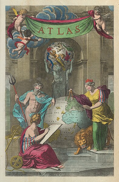
Français : Atlas der wereld, de Jan Barend Elwe; publié à Amsterdam en 1792. Reliure en demi-veau de l'époque sur cartons marbrés. Avec ornementation et titre dorés au dos. Collation - Folio : 22 pages, 40 feuillets de planches. Composé d'un texte typographique, d'une page de titre gravée, de 37 cartes, d'une chronologie et d'un tableau des distances pour l'Europe. La couverture géographique comprend l'Europe, la Russie, le Moyen-Orient, la Terre Sainte, l'Asie de l'Est et du Sud-Est, l'Afrique, l'Amérique du Nord et l'Amérique du Sud. Les cartes montrent les continents, les pays, les régions, les villes, les églises, les chemins de fer, la topographie, les déserts, les plans d'eau, le drainage, les côtes, les îles et les routes d'exploration. Avec des vignettes picturales de personnages, de faune et de flore. Cet atlas historique dans lequel Elwe a réédité des cartes de De L'Isle, Ottens, Jaillot et d'autres cartographes du XVIIe siècle a poursuivi la tradition de cartographie franco-néerlandaise du XVIIe siècle bien après qu'elle ait été éclipsée par les cartographes anglais du XVIIIe siècle. L'ouvrage est un serre-livre intrigant sur une tradition cartographique - "l'âge d'or de la cartographie" - qui a façonné une grande partie du monde moderne.
English: Atlas der wereld, by Jan Barend Elwe; published in Amsterdam, 1792. Bound in contemporary half-calf over marbled paper boards. With gilt ornamentation and title on spine. Collation - Folio: 22 pages, 40 leaves of plates. Comprised of letterpress text, an engraved title page, 37 maps, one timeline and one table of distances for Europe. Geographic coverage includes Europe, Russia, the Middle East, the Holy Land, East and Southeast Asia, Africa, North America and South America. Maps show continents, countries, regions, cities, churches, railways, topography, deserts, bodies of water, drainage, coastlines, islands and routes of exploration. With pictorial vignettes of figures, fauna and flora. This historical atlas in which Elwe re-issued maps by De L’Isle, Ottens, Jaillot, and other 17th-century cartographers continued the 17th-century Franco-Dutch mapmaking tradition long after it had been eclipsed by the 18th-century English mapmakers. The work is an intriguing bookend on a cartographic tradition - “the golden age of cartography” - that shaped much of the modern world. |
|||||||||||||||||||
| Date | ||||||||||||||||||||
| Source | list, main | |||||||||||||||||||
| Author |
creator QS:P170,Q59627593 |
|||||||||||||||||||
| Other versions |
|
|||||||||||||||||||
Licensing[edit]
|
This is a faithful photographic reproduction of a two-dimensional, public domain work of art. The work of art itself is in the public domain for the following reason:
The official position taken by the Wikimedia Foundation is that "faithful reproductions of two-dimensional public domain works of art are public domain".
This photographic reproduction is therefore also considered to be in the public domain in the United States. In other jurisdictions, re-use of this content may be restricted; see Reuse of PD-Art photographs for details. | |||||
File history
Click on a date/time to view the file as it appeared at that time.
| Date/Time | Thumbnail | Dimensions | User | Comment | |
|---|---|---|---|---|---|
| current | 19:30, 20 July 2023 |  | 7,449 × 11,395 (37.35 MB) | Yann (talk | contribs) | File:Atlas der wereld (14478002).jpg cropped 20 % horizontally, 19 % vertically using CropTool with lossless mode. |
You cannot overwrite this file.
File usage on Commons
The following 3 pages use this file:
File usage on other wikis
The following other wikis use this file:
- Usage on www.wikidata.org
