File:Atlas Van der Hagen-KW1049B13 086-Mappa AESIVARVM Insularum alias BARMVDAS dictarum, ad Ostia Mexicani aestuarij jacentium in latitudine Graduum 32 Minutorium 25 Ab Anglia.jpeg
Jump to navigation
Jump to search

Size of this preview: 771 × 600 pixels. Other resolutions: 309 × 240 pixels | 617 × 480 pixels | 987 × 768 pixels | 1,280 × 996 pixels | 2,560 × 1,992 pixels | 5,500 × 4,280 pixels.
Original file (5,500 × 4,280 pixels, file size: 3.37 MB, MIME type: image/jpeg)
Captions
Captions
Add a one-line explanation of what this file represents
Summary[edit]
| Dirk Jansz van Santen: Atlas van Dirk van der Hagen (volledig, collectie KB)
|
|||||||||||||||||||||||||||||
|---|---|---|---|---|---|---|---|---|---|---|---|---|---|---|---|---|---|---|---|---|---|---|---|---|---|---|---|---|---|
| Artist |
|
 | |||||||||||||||||||||||||||
| Author |
Publisher:
|
||||||||||||||||||||||||||||
| Title |
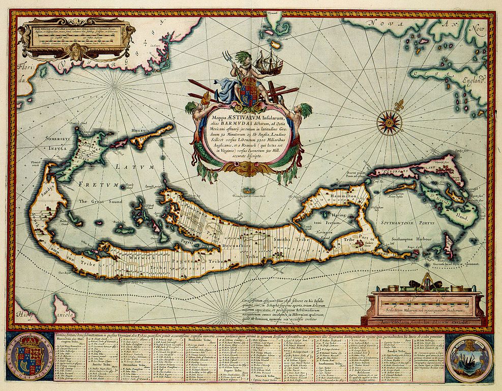
Mappa AESIVARVM Insularum alias BARMVDAS dictarum, ad Ostia Mexicani aestuarij jacentium in latitudine Graduum 32 Minutorium 25 Ab Anglia |
||||||||||||||||||||||||||||
| Object type | map | ||||||||||||||||||||||||||||
| Description |
Nederlands: Deze kaart van Bermuda werd in 1630 voor het gepubliceerd door Willem Jansz. Blaeu (1571-1638). Blaeu kopieerde de kaart naar een voorbeeld van de Engelse kartograaf John Speed (1552-1629) uit 1626. Speed had de afbeelding op zijn beurt weer ontleend aan een kaart van de Engelse landmeter Richard Norwood (1590-1675) uit 1622. Het centrale thema van de kaart is de verspreiding van het landbezit op de eilandengroep. In het register langs de onderzijde van de kaart kan de verdeling van het landbezit met naam en toenaam worden afgeleid.
English: This map of the Bermudas was published by Willem Jansz. Blaeu (1571-1638) in 1630. Blaeu copied the map after an example from 1626 by the English cartographer John Speed (1552-1629), while Speed had used a map by the English surveyor Richard Norwood (1590-1675) from 1622 as his source. The central theme on the map is the distribution of landownerships on the islands. The register along the lower part of the map explaines the distribution of lands and the names of owners. |
||||||||||||||||||||||||||||
| Language |
Dutch |
||||||||||||||||||||||||||||
| Date | 1630 | ||||||||||||||||||||||||||||
| Publication date |
circa |
||||||||||||||||||||||||||||
| Medium |
Nederlands: kopergravure
English: copper engraving print |
||||||||||||||||||||||||||||
| Dimensions | 40 x 62 cm | ||||||||||||||||||||||||||||
| Collection |
|
||||||||||||||||||||||||||||
| Accession number |
Description of the Atlas Van der Hagen in the catalogue of the KB: http://opc4.kb.nl/DB=1/TTL=1/LNG=EN/PPN?PPN=353012750 |
||||||||||||||||||||||||||||
| Place of creation |
Netherlands |
||||||||||||||||||||||||||||
| Notes | KW1049B13_086 - Volume 1 | ||||||||||||||||||||||||||||
| Related persons | Willem Jansz. Blaeu - John Speed - Norwood, Richard | ||||||||||||||||||||||||||||
| Depicted locations | Central-America - Bermuda | ||||||||||||||||||||||||||||
| References | |||||||||||||||||||||||||||||
| Source/Photographer |
Source page at the Geheugen van Nederland / Memory of the Netherlands website.
|
||||||||||||||||||||||||||||
| Permission (Reusing this file) |
|
||||||||||||||||||||||||||||


File history
Click on a date/time to view the file as it appeared at that time.
| Date/Time | Thumbnail | Dimensions | User | Comment | |
|---|---|---|---|---|---|
| current | 17:18, 17 July 2015 | | 5,500 × 4,280 (3.37 MB) | OlafJanssen (talk | contribs) | GWToolset: Creating mediafile for OlafJanssen. |
You cannot overwrite this file.
File usage on Commons
The following 5 pages use this file:
- Atlas van der Hagen
- Atlas van der Hagen (Volume 4)
- Koninklijke Bibliotheek/Maps and atlases
- Maps and atlases from Koninklijke Bibliotheek
- File:Atlas Van der Hagen-KW1049B13 086-Mappa AESIVARVM Insularum alias BARMVDAS dictarum, ad Ostia Mexicani aestuarij jacentium in latitudine Graduum 32 Minutorium 25 Ab Anglia.jpeg
File usage on other wikis
The following other wikis use this file:
- Usage on fr.wikipedia.org