File:Atlas Van der Hagen-KW1049B11 073-GEOGRAPHICA ARTESIAE COMITATUS TABULA,.jpeg
Jump to navigation
Jump to search
Size of this preview: 714 × 599 pixels. Other resolutions: 286 × 240 pixels | 572 × 480 pixels | 915 × 768 pixels | 1,220 × 1,024 pixels | 2,440 × 2,048 pixels | 5,500 × 4,616 pixels.
Original file (5,500 × 4,616 pixels, file size: 5.03 MB, MIME type: image/jpeg)
Captions
Captions
Add a one-line explanation of what this file represents
Summary
[edit]| Dirk Jansz van Santen: Atlas van Dirk van der Hagen (volledig, collectie KB)
|
||||||||||||||||||||||||||||||||||||||||||||||||||||
|---|---|---|---|---|---|---|---|---|---|---|---|---|---|---|---|---|---|---|---|---|---|---|---|---|---|---|---|---|---|---|---|---|---|---|---|---|---|---|---|---|---|---|---|---|---|---|---|---|---|---|---|---|
| Artist |
|
 | ||||||||||||||||||||||||||||||||||||||||||||||||||
| Author |
Publisher:
|
|||||||||||||||||||||||||||||||||||||||||||||||||||
| Title |
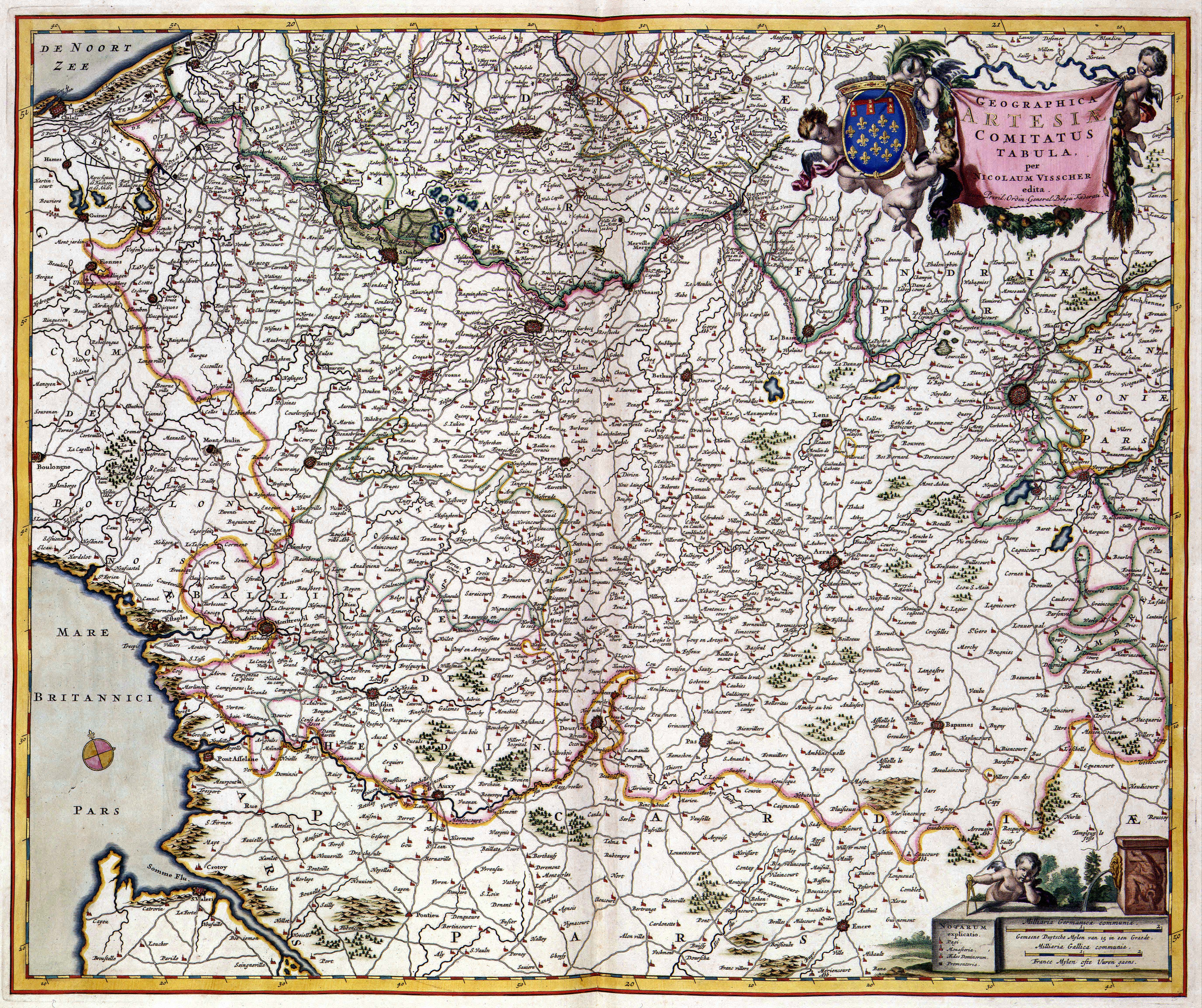
GEOGRAPHICA ARTESIAE COMITATUS TABULA, |
|||||||||||||||||||||||||||||||||||||||||||||||||||
| Object type | map | |||||||||||||||||||||||||||||||||||||||||||||||||||
| Description |
Nederlands: Deze kaart van het graafschap Artois werd na 1681 uitgegeven door Nicolaes Visscher II (1649-1702). Als bron greep Visscher waarschijnlijk terug op Nederlands en Vlaams kaartmateriaal dat in de eerste helft van de 17de eeuw was uitgegeven.
English: This map of the county Artois was published by Nicolaes Visscher II (1649-1702) after 1681. For this map, Visscher probable used Dutch and Flemish sources from the first half of the 17th century. |
|||||||||||||||||||||||||||||||||||||||||||||||||||
| Language |
Dutch |
|||||||||||||||||||||||||||||||||||||||||||||||||||
| Date | after 1681 | |||||||||||||||||||||||||||||||||||||||||||||||||||
| Publication date |
circa |
|||||||||||||||||||||||||||||||||||||||||||||||||||
| Medium |
Nederlands: kopergravure
English: copper engraving print |
|||||||||||||||||||||||||||||||||||||||||||||||||||
| Dimensions | 46,5 x 56 cm | |||||||||||||||||||||||||||||||||||||||||||||||||||
| Collection |
|
|||||||||||||||||||||||||||||||||||||||||||||||||||
| Accession number |
Description of the Atlas Van der Hagen in the catalogue of the KB: http://opc4.kb.nl/DB=1/TTL=1/LNG=EN/PPN?PPN=353012750 |
|||||||||||||||||||||||||||||||||||||||||||||||||||
| Place of creation | Amsterdam | |||||||||||||||||||||||||||||||||||||||||||||||||||
| Notes | KW1049B11_073 - Volume 1 | |||||||||||||||||||||||||||||||||||||||||||||||||||
| Related persons | Nicolaes Visscher II | |||||||||||||||||||||||||||||||||||||||||||||||||||
| Depicted locations | Artois - Belgium | |||||||||||||||||||||||||||||||||||||||||||||||||||
| References | ||||||||||||||||||||||||||||||||||||||||||||||||||||
| Source/Photographer |
Source page at the Geheugen van Nederland / Memory of the Netherlands website.
|
|||||||||||||||||||||||||||||||||||||||||||||||||||
| Permission (Reusing this file) |
|
|||||||||||||||||||||||||||||||||||||||||||||||||||
| Other versions | ||||||||||||||||||||||||||||||||||||||||||||||||||||

.jpeg)
.jpeg)
.jpeg)
.jpeg)
.jpeg)
File history
Click on a date/time to view the file as it appeared at that time.
| Date/Time | Thumbnail | Dimensions | User | Comment | |
|---|---|---|---|---|---|
| current | 14:20, 17 July 2015 | | 5,500 × 4,616 (5.03 MB) | OlafJanssen (talk | contribs) | GWToolset: Creating mediafile for OlafJanssen. |
You cannot overwrite this file.
File usage on Commons
The following 11 pages use this file:
- Atlas van der Hagen
- Atlas van der Hagen (Volume 2)
- File:Atlas Van der Hagen-KW1049B11 073-GEOGRAPHICA ARTESIAE COMITATUS TABULA,.jpeg
- File:Atlas Van der Hagen-KW1049B11 073-GEOGRAPHICA ARTESIAE COMITATUS TABULA, (Aire-sur-la-Lys).jpeg
- File:Atlas Van der Hagen-KW1049B11 073-GEOGRAPHICA ARTESIAE COMITATUS TABULA, (Montreuil).jpeg
- File:Atlas Van der Hagen-KW1049B11 073-GEOGRAPHICA ARTESIAE COMITATUS TABULA, (Saint-Omer).jpeg
- File:Atlas Van der Hagen-KW1049B11 073-GEOGRAPHICA ARTESIAE COMITATUS TABULA, (Thérouanne).jpeg
- File:Atlas Van der Hagen-KW1049B11 073-GEOGRAPHICA ARTESIAE COMITATUS TABULA, (arras).jpeg
- File:Atlas Van der Hagen-KW1049B11 073-GEOGRAPHICA ARTESIAE COMITATUS TABULA, (bapaume).jpeg
- File:Atlas Van der Hagen-KW1049B11 073-GEOGRAPHICA ARTESIAE COMITATUS TABULA, (crotoy).jpeg
- File:Atlas Van der Hagen-KW1049B11 073-GEOGRAPHICA ARTESIAE COMITATUS TABULA, (lens).jpeg
.jpeg)
.jpeg)
.jpeg)