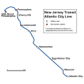
File:Atlantic City Line.svg
From Wikimedia Commons, the free media repository
Jump to navigation
Jump to search

Size of this PNG preview of this SVG file: 600 × 600 pixels. Other resolutions: 240 × 240 pixels | 480 × 480 pixels | 768 × 768 pixels | 1,024 × 1,024 pixels | 2,048 × 2,048 pixels | 1,800 × 1,800 pixels.
Original file (SVG file, nominally 1,800 × 1,800 pixels, file size: 310 KB)
File information
Structured data
Captions
Captions
Add a one-line explanation of what this file represents
Summary
[edit]| DescriptionAtlantic City Line.svg | NJ Transit Atlantic City Line route map. Created from a non-copyrighted NJDOT map of NJ railroads as well as non-copyrighted GIS data. |
| Date | |
| Source | Own work |
| Author | lensovet |
Licensing
[edit]| I, lensovet, the author of this work, hereby publish it under the following licenses: | ||||
To provide attribution, credit the author as lensovet. You may select the license of your choice. |
File history
Click on a date/time to view the file as it appeared at that time.
| Date/Time | Thumbnail | Dimensions | User | Comment | |
|---|---|---|---|---|---|
| current | 20:18, 22 October 2013 |  | 1,800 × 1,800 (310 KB) | Dusso Janladde (talk | contribs) | Really fix it this time! |
| 19:51, 22 October 2013 |  | 1,800 × 1,800 (309 KB) | Dusso Janladde (talk | contribs) | Fix text for Pennsauken station | |
| 19:46, 22 October 2013 |  | 1,800 × 1,800 (296 KB) | Dusso Janladde (talk | contribs) | Added Pennsauken Station | |
| 20:50, 6 October 2009 |  | 1,800 × 1,800 (293 KB) | Dream out loud (talk | contribs) | updated file for much better legibility (still geographically accurate) | |
| 19:01, 16 July 2006 |  | 1,520 × 1,520 (21 KB) | Lensovet (talk | contribs) | w:NJ Transit w:Atlantic City Line route map. Created from a non-copyrighted NJDOT map of NJ railroads as well as non-copyrighted GIS data. Created by lensovet using Inkscape. |
You cannot overwrite this file.
File usage on Commons
There are no pages that use this file.
Metadata
This file contains additional information such as Exif metadata which may have been added by the digital camera, scanner, or software program used to create or digitize it. If the file has been modified from its original state, some details such as the timestamp may not fully reflect those of the original file. The timestamp is only as accurate as the clock in the camera, and it may be completely wrong.
| Width | 1800 |
|---|---|
| Height | 1800 |
