File:AtlBalk.a-660.jpg
Jump to navigation
Jump to search
No higher resolution available.
AtlBalk.a-660.jpg (318 × 327 pixels, file size: 25 KB, MIME type: image/jpeg)
Captions
Captions
Add a one-line explanation of what this file represents
Summary
[edit]
| Description |
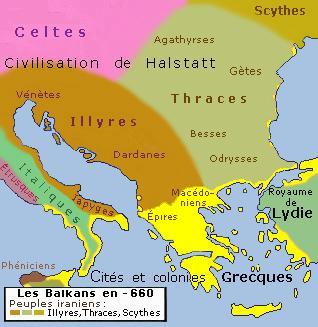
English: Historic map of Balkan peninsula 660 bc
Français : Carte des Balkans en 660 avant n.e. |
| Date | |
| Source | Own work |
| Author | Spiridon MANOLIU |
Licensing
[edit]
I, the copyright holder of this work, hereby publish it under the following licenses:

|
Permission is granted to copy, distribute and/or modify this document under the terms of the GNU Free Documentation License, Version 1.2 or any later version published by the Free Software Foundation; with no Invariant Sections, no Front-Cover Texts, and no Back-Cover Texts. A copy of the license is included in the section entitled GNU Free Documentation License. |
This file is licensed under the Creative Commons Attribution-Share Alike 3.0 Unported, 2.5 Generic, 2.0 Generic and 1.0 Generic license.
- You are free:
- to share – to copy, distribute and transmit the work
- to remix – to adapt the work
- Under the following conditions:
- attribution – You must give appropriate credit, provide a link to the license, and indicate if changes were made. You may do so in any reasonable manner, but not in any way that suggests the licensor endorses you or your use.
- share alike – If you remix, transform, or build upon the material, you must distribute your contributions under the same or compatible license as the original.
You may select the license of your choice.
File history
Click on a date/time to view the file as it appeared at that time.
| Date/Time | Thumbnail | Dimensions | User | Comment | |
|---|---|---|---|---|---|
| current | 03:52, 20 March 2023 | | 318 × 327 (25 KB) | Alexikoua (talk | contribs) | OR, there was no Illyrian presence in Molossia |
| 01:15, 30 December 2022 |  | 318 × 327 (141 KB) | Maleschreiber (talk | contribs) | rv the old version has a better depiction of the boundary line | |
| 03:00, 7 December 2022 |  | 318 × 327 (25 KB) | Alexikoua (talk | contribs) | per bibliography, Illyrians don't expaned too sout | |
| 12:09, 3 August 2013 |  | 318 × 327 (141 KB) | Spiridon Ion Cepleanu (talk | contribs) | Since Athen2004 but also since the atlases cited as sources. | |
| 08:30, 17 December 2011 |  | 318 × 327 (25 KB) | Athens2004 (talk | contribs) | fixes | |
| 07:56, 17 December 2011 |  | 318 × 327 (26 KB) | Athens2004 (talk | contribs) | Reverted to version as of 07:54, 17 December 2011 | |
| 07:55, 17 December 2011 |  | 318 × 327 (26 KB) | Athens2004 (talk | contribs) | same | |
| 07:54, 17 December 2011 |  | 318 × 327 (26 KB) | Athens2004 (talk | contribs) | minor modification | |
| 18:58, 1 March 2010 |  | 318 × 327 (139 KB) | Spiridon Ion Cepleanu (talk | contribs) | {{Information |Description={{en|1=Historic map of Balkan peninsula 660 bc}} {{fr|1=Carte des Balkans en 660 avant n.e.}} |Source={{own}} |Author=Spiridon MANOLIU |Date=March 1, 2010 |Permission= |other_versions= }} [[Category:Ma |
You cannot overwrite this file.
File usage on Commons
The following 4 pages use this file:
File usage on other wikis
The following other wikis use this file:
- Usage on fr.wikipedia.org
- Histoire de la Roumanie
- Histoire de l'Albanie
- Histoire de la Bulgarie
- Histoire de la Croatie
- Histoire de la Hongrie
- Histoire de la Slovénie
- Histoire de la Serbie
- Histoire de la Macédoine du Nord
- Histoire de la Bosnie-Herzégovine
- Histoire du Monténégro
- Histoire de la Moldavie
- Portail:Balkans
- Portail:Balkans/Histoire
- Histoire des Balkans