File:Astroites.jpg
Astroites.jpg (366 × 256 pixels, file size: 26 KB, MIME type: image/jpeg)
Captions
Captions
Summary
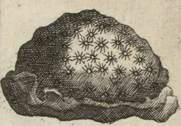
[edit]| English: Astroites, or Star-Stone with Round radiated Holes in its surface found at Cortenhall
( |
|||||||||||||||||||||||||||
|---|---|---|---|---|---|---|---|---|---|---|---|---|---|---|---|---|---|---|---|---|---|---|---|---|---|---|---|
| Author |
|
||||||||||||||||||||||||||
| Title |
English: Astroites, or Star-Stone with Round radiated Holes in its surface found at Cortenhall |
||||||||||||||||||||||||||
| Description |
English: A depiction of an astroites—presumably some form of fossilized sponge—from the figures decorating the margins of Moll's map of Northamptonshire, sold separately and as Map 25 in his Set of Fifty New and Correct Maps of England and Wales...
Français : Sujet : Fossiles
Mosaïque antique Météorites Divisions politiques et administratives Northampton, Comté de -- Divisions politiques et administratives Échelle(s) : 10 English Miles [= 4,6 cm] Référence bibliographique : 173 Appartient à l’ensemble documentaire : AnvilEur Appartient à l’ensemble documentaire : MAEDI008 Appartient à l’ensemble documentaire : MAEDIGen0 Couverture : Royaume-Uni – Angleterre – Northamptonshire Langue : anglais Éditeur : [T. Bowles] (London) |
||||||||||||||||||||||||||
| Date | 1724 | ||||||||||||||||||||||||||
| Dimensions | height: 33 cm (12.9 in); width: 23.5 cm (9.2 in) | ||||||||||||||||||||||||||
| Collection |
|
||||||||||||||||||||||||||
| References |
Français : Notice de recueil : http://catalogue.bnf.fr/ark:/12148/cb40577015h
Appartient à : Collection d'Anville ; 02275 Notice du catalogue : http://catalogue.bnf.fr/ark:/12148/cb41292713k Extrait de A New Description of England and Wales, With the Adjacent Islands, 1724. |
||||||||||||||||||||||||||
| Source/Photographer |
Français : Bibliothèque nationale de France, département Cartes et plans, GE DD-2987 (2275)
Bibliothèque nationale de France |
||||||||||||||||||||||||||
| Other versions |
|
||||||||||||||||||||||||||


.jpg)
|
This work is in the public domain in its country of origin and other countries and areas where the copyright term is the author's life plus 100 years or fewer. | |
| This file has been identified as being free of known restrictions under copyright law, including all related and neighboring rights. | |
File history
Click on a date/time to view the file as it appeared at that time.
| Date/Time | Thumbnail | Dimensions | User | Comment | |
|---|---|---|---|---|---|
| current | 08:57, 16 December 2023 | | 366 × 256 (26 KB) | LlywelynII (talk | contribs) | Cropped and rotated 0.99°. |
| 08:56, 16 December 2023 |  | 401 × 269 (30 KB) | LlywelynII (talk | contribs) | File:Northampton Shire - By H. Moll Geographer - btv1b53056209m.jpg cropped. |
You cannot overwrite this file.
File usage on Commons
The following 2 pages use this file: