File:Ascensor da Nazaré - Portugal (51355246824).jpg

Original file (3,456 × 5,184 pixels, file size: 16.75 MB, MIME type: image/jpeg)
Captions
Captions
Summary[edit]
.jpg&action=edit§ion=1)
| Description |
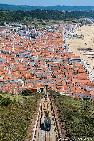
O Elevador da Nazaré é um funicular localizado na Nazaré, em Portugal. É explorado pela Câmara Municipal da Nazaré e liga o centro da vila, a Praia da Nazaré, ao Sítio da Nazaré. É um dos transportes deste tipo com maior tráfego em Portugal, atingindo um milhão de passageiros por ano Efetua cada viagem em 15 minutos, ao preço de 1,00 € (criança) e 1,50 € (adulto). O elevador foi inaugurado a 28 de Julho de 1889, com projecto de Raul Mesnier. Originalmente funcionava a vapor, apenas na época balnear (estando aberto todo o ano já nos anos 1930), com viagens das 06:00 às 21:00 custando entre 0$020 e 0$120.[2] As cabinas tiveram libré vermelha até à renovação de 2002; inicialmente transportavam 60 passageiros. O funicular da Nazaré foi adquirido em 1924 pela Confraria de Nossa Senhora da Nazaré, gestora do santuário, e em 1932 passou para as mãos da Câmara Municipal, por 398 031$850. A 15 de Fevereiro de 1963[2] sofreu o único acidente da sua história, devido à rutura do cabo, de que resultaram dois mortos. Esteve parado cinco anos e reabriu em 1968, funcionando a electricidade e tendo sido dotado de melhores sistemas de segurança com um triplo sistema de travagem. Entre setembro de 2001 e junho de 2002 esteve fechado para uma remodelação profunda com substituição das cabinas (nova libré azul) e renovação dos terminais. Características Distância: 318 metros (50 em túnel) Inclinação: 42% Via própria, cercada, de declive constante; cabo a descoberto sobre roldanas. <a href="https://pt.wikipedia.org/wiki/Elevador_da_Nazar%c3%a9" rel="noreferrer nofollow">pt.wikipedia.org/wiki/Elevador_da_Nazar%C3%A9</a> |
| Date | |
| Source | Ascensor da Nazaré - Portugal 🇵🇹 |
| Author | Vitor Oliveira from Torres Vedras, PORTUGAL |
| Camera location | | View this and other nearby images on: OpenStreetMap |
|---|
.jpg¶ms=039.604922_N_-009.074285_E_globe:Earth_type:camera_source:Flickr_&language=en)
Licensing[edit]
.jpg&action=edit§ion=2)
- You are free:
- to share – to copy, distribute and transmit the work
- to remix – to adapt the work
- Under the following conditions:
- attribution – You must give appropriate credit, provide a link to the license, and indicate if changes were made. You may do so in any reasonable manner, but not in any way that suggests the licensor endorses you or your use.
- share alike – If you remix, transform, or build upon the material, you must distribute your contributions under the same or compatible license as the original.
| This image was originally posted to Flickr by Portuguese_eyes at https://flickr.com/photos/21446942@N00/51355246824. It was reviewed on 23 August 2021 by FlickreviewR 2 and was confirmed to be licensed under the terms of the cc-by-sa-2.0. |
File history
Click on a date/time to view the file as it appeared at that time.
| Date/Time | Thumbnail | Dimensions | User | Comment | |
|---|---|---|---|---|---|
| current | 16:18, 23 August 2021 | | 3,456 × 5,184 (16.75 MB) | Tm (talk | contribs) | Transferred from Flickr via #flickr2commons |
You cannot overwrite this file.
File usage on Commons
The following page uses this file:
.jpg&oldid=804919578)