File:ArxipèlagÀrticCanadenc.png
Jump to navigation
Jump to search
Size of this preview: 622 × 600 pixels. Other resolutions: 249 × 240 pixels | 498 × 480 pixels | 700 × 675 pixels.
Original file (700 × 675 pixels, file size: 98 KB, MIME type: image/png)
Captions
Captions
Add a one-line explanation of what this file represents
Summary
[edit]
| Description |
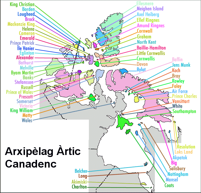
English: Map of the islands in the Canadian Arctic Archipelago
Català: Mapa de les illes de l'Arxipèlag Àrtic Canadenc |
| Date | 12.06.08 |
| Source | Fitxer original:Canadarcticislands.gif. Traducció al català: obra pròpia |
| Author | Quico Llach, basat en el fitxer original de l'usuari Timvasquez |
Licensing
[edit]
| I, the copyright holder of this work, release this work into the public domain. This applies worldwide. In some countries this may not be legally possible; if so: I grant anyone the right to use this work for any purpose, without any conditions, unless such conditions are required by law. |
File history
Click on a date/time to view the file as it appeared at that time.
| Date/Time | Thumbnail | Dimensions | User | Comment | |
|---|---|---|---|---|---|
| current | 18:58, 12 June 2008 | | 700 × 675 (98 KB) | Qllach (talk | contribs) | {{Information |Description={{en|1=Map of the islands in the Canadian Arctic Archipelago}} {{ca|1=Mapa de les illes de l'Arxipèlag Àrtic Canadenc}} |Source=Fitxer original:Canadarcticislands.gif. Traducció al català: obra pròpia |Author=Quico Llach, b |
You cannot overwrite this file.
File usage on Commons
There are no pages that use this file.
File usage on other wikis
The following other wikis use this file:
- Usage on ca.wikipedia.org