File:Armenian population map 1896.jpg
Jump to navigation
Jump to search

Size of this preview: 722 × 599 pixels. Other resolutions: 289 × 240 pixels | 578 × 480 pixels | 925 × 768 pixels | 1,234 × 1,024 pixels | 2,468 × 2,048 pixels | 2,964 × 2,460 pixels.
Original file (2,964 × 2,460 pixels, file size: 2.88 MB, MIME type: image/jpeg)
Captions
Captions
Add a one-line explanation of what this file represents
|
|

Summary[edit]
| Description |
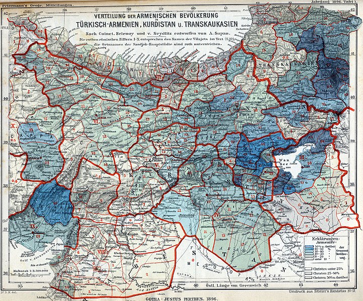
English: The Armenian population in historical Armenian regions in 1896. The Armenian population is represented in the colored areas, as well as in the red Arabic numbers, indicating their exact percentage. |
| Date | |
| Source | Petermanns Geographische Mitteilungen |
| Author | own scan |
| Other versions |
Derivative works of this file: |
Licensing[edit]
The copyright situation of this work is theoretically uncertain, because in the country of origin copyright lasts 70 years after the death of the author, and the date of the author's death is unknown. However, the date of creation of the work was over 120 years ago, and it is thus a reasonable assumption that the copyright has expired (see here for the community discussion). Do not use this template if the date of death of the author is known.
| |
| This file has been identified as being free of known restrictions under copyright law, including all related and neighboring rights. | |
This work is in the public domain in the United States because it was published (or registered with the U.S. Copyright Office) before January 1, 1929.
Public domain works must be out of copyright in both the United States and in the source country of the work in order to be hosted on the Commons. If the work is not a U.S. work, the file must have an additional copyright tag indicating the copyright status in the source country.
Note: This tag should not be used for sound recordings. |
File history
Click on a date/time to view the file as it appeared at that time.
| Date/Time | Thumbnail | Dimensions | User | Comment | |
|---|---|---|---|---|---|
| current | 15:41, 15 November 2009 | | 2,964 × 2,460 (2.88 MB) | Alex:D (talk | contribs) | whitened |
| 14:57, 14 June 2008 |  | 2,964 × 2,460 (3.96 MB) | Olahus (talk | contribs) | {{Information |Description={{en|1=The Armenian population in hostorical Armenian regions in the year 1896.}} |Source=Petermanns Mitteilungen |Author=own scan |Date=1896 |Permission= |other_versions= }} {{ImageUpload|full}} |
You cannot overwrite this file.
File usage on Commons
The following 9 pages use this file:
- User:Olahus
- Commons:Graphic Lab/Map workshop/Archive/2014
- File:Armenian population map 1896 Erklärungen.jpg
- File:Armenian population map 1896 cropped.jpg
- File:Armenian population map 1896 cropped 2.jpg
- File:Armenian population map 1896 cropped 3.jpg
- File:Armenian population map 1896 cropped Kurdistan.jpg
- File:Armenian population map 1896 cropped Lake Van.jpg
- File:Armenian population map 1896 cropped Lazistan.jpg
File usage on other wikis
The following other wikis use this file:
- Usage on af.wikipedia.org
- Usage on ast.wikipedia.org
- Usage on azb.wikipedia.org
- Usage on ba.wikipedia.org
- Usage on be.wikipedia.org
- Usage on cs.wikipedia.org
- Usage on da.wikipedia.org
- Usage on de.wikipedia.org
- Usage on en.wikipedia.org
- Decline and modernization of the Ottoman Empire
- Armenian Kingdom of Cilicia
- Ottoman Armenian population
- Armenian national movement
- Armenians in the Ottoman Empire
- User:Olahus
- Demographics of the Ottoman Empire
- Wikipedia:Graphics Lab/Map workshop/Archive/May 2010
- User:Yerevantsi/Sources
- User:C3qiuhao/sandbox
- User:Falcaorib
- Talk:Armenian genocide/Archive 28
- Usage on eo.wikipedia.org
- Usage on es.wikipedia.org
- Usage on fr.wikipedia.org
- Usage on fy.wikipedia.org
- Usage on hy.wikipedia.org
- Usage on hyw.wikipedia.org
- Usage on id.wikipedia.org
- Usage on it.wikipedia.org
- Usage on ja.wikipedia.org
- Usage on ka.wikipedia.org
- Usage on ms.wikipedia.org
- Usage on nl.wikipedia.org
View more global usage of this file.