File:Area by country topten.PNG
Jump to navigation
Jump to search

Size of this preview: 800 × 351 pixels. Other resolutions: 320 × 140 pixels | 640 × 281 pixels | 1,442 × 633 pixels.
Original file (1,442 × 633 pixels, file size: 59 KB, MIME type: image/png)
Captions
Captions
Add a one-line explanation of what this file represents

|
This map of the world image could be re-created using vector graphics as an SVG file. This has several advantages; see Commons:Media for cleanup for more information. If an SVG form of this image is available, please upload it and afterwards replace this template with
{{vector version available|new image name}}.
It is recommended to name the SVG file “Area by country topten.svg”—then the template Vector version available (or Vva) does not need the new image name parameter. |
Summary[edit]
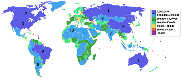
Area in square kilometres of countries of the world, based on information at CIA factbook archive copy at the Wayback Machine and using Image:BlankMap-World-v5.png.
Licensing[edit]

|
Permission is granted to copy, distribute and/or modify this document under the terms of the GNU Free Documentation License, Version 1.2 or any later version published by the Free Software Foundation; with no Invariant Sections, no Front-Cover Texts, and no Back-Cover Texts. A copy of the license is included in the section entitled GNU Free Documentation License. |
| This file is licensed under the Creative Commons Attribution-Share Alike 3.0 Unported license. | ||
| ||
| This licensing tag was added to this file as part of the GFDL licensing update. |
File history
Click on a date/time to view the file as it appeared at that time.
| Date/Time | Thumbnail | Dimensions | User | Comment | |
|---|---|---|---|---|---|
| current | 10:47, 10 August 2011 | | 1,442 × 633 (59 KB) | Tiiliskivi (talk | contribs) | Still made one mistake... |
| 10:46, 10 August 2011 |  | 1,442 × 633 (59 KB) | Tiiliskivi (talk | contribs) | Whoops! Not Libya, Algeria. | |
| 12:16, 10 July 2011 |  | 1,442 × 633 (59 KB) | Tiiliskivi (talk | contribs) | South Sudan -related fixes | |
| 05:19, 5 April 2006 |  | 1,442 × 633 (37 KB) | Roke~commonswiki (talk | contribs) | Area in square kilometres of countries of the world, based on information at [http://www.cia.gov/cia/publications/factbook/rankorder/2147rank.html CIA factbook] and using Image:BlankMap-World-v5.png, with the top ten countries by area marked. For a v |
You cannot overwrite this file.
File usage on Commons
There are no pages that use this file.