File:Arctic-umiaq-line-ports-of-call.svg
Jump to navigation
Jump to search

Size of this PNG preview of this SVG file: 300 × 500 pixels. Other resolutions: 144 × 240 pixels | 288 × 480 pixels | 461 × 768 pixels | 614 × 1,024 pixels | 1,229 × 2,048 pixels.
Original file (SVG file, nominally 300 × 500 pixels, file size: 26 KB)
Captions
Captions
Add a one-line explanation of what this file represents
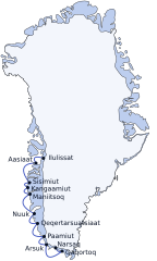
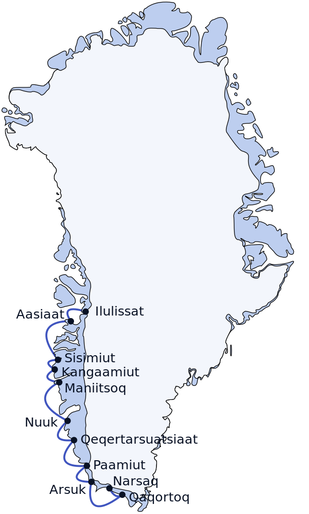
| Description | Arctic Umiaq coastal ship route Ilulissat-Narsaq, alongside the coast of western, southwestern, and southern Greenland. |
| Date | (UTC) |
| Source | |
| Author |
|
I, the copyright holder of this work, hereby publish it under the following license:
| I, the copyright holder of this work, release this work into the public domain. This applies worldwide. In some countries this may not be legally possible; if so: I grant anyone the right to use this work for any purpose, without any conditions, unless such conditions are required by law. |
File history
Click on a date/time to view the file as it appeared at that time.
| Date/Time | Thumbnail | Dimensions | User | Comment | |
|---|---|---|---|---|---|
| current | 03:55, 29 March 2010 | | 300 × 500 (26 KB) | Algkalv (talk | contribs) | Sans rect. |
| 12:53, 4 February 2009 |  | 300 × 500 (26 KB) | Algkalv (talk | contribs) | optimization | |
| 18:55, 18 January 2009 |  | 300 × 500 (60 KB) | Algkalv (talk | contribs) | Improve beziers for small hoops + small readability fixes | |
| 17:23, 18 January 2009 |  | 300 × 500 (60 KB) | Algkalv (talk | contribs) | librsvg is dumb as a bag of hammers | |
| 17:20, 18 January 2009 |  | 300 × 500 (60 KB) | Algkalv (talk | contribs) | Converter bughouse workaround #2 - use white rectangle as 'canvas', fill the beziers with white, and move them z-index-wise between the rectangle and the contour paths | |
| 17:12, 18 January 2009 |  | 300 × 500 (60 KB) | Algkalv (talk | contribs) | Bughouse workaround #1 - try fill-opacity | |
| 17:05, 18 January 2009 |  | 300 × 500 (60 KB) | Algkalv (talk | contribs) | the SVG-to-PNG library is broken | |
| 17:03, 18 January 2009 |  | 300 × 500 (60 KB) | Algkalv (talk | contribs) | reduce to CSS2 selectors | |
| 17:01, 18 January 2009 |  | 300 × 500 (60 KB) | Algkalv (talk | contribs) | Doesn't understand HSL or cascade well | |
| 16:58, 18 January 2009 |  | 300 × 500 (60 KB) | Algkalv (talk | contribs) | {{Information |Description=Arctic Umiaq route alongside the coast of western, southwestern, and southern Greenland. |Source=*Greenland_stub.svg |Date=2009-01-14 21:00 (UTC) |Author=*derivative work: Algkalv ([ |
You cannot overwrite this file.
File usage on Commons
There are no pages that use this file.
File usage on other wikis
The following other wikis use this file:
- Usage on da.wikipedia.org
- Usage on de.wikipedia.org
- Usage on el.wikivoyage.org
- Usage on en.wikipedia.org
- Usage on fr.wikipedia.org
- Usage on id.wikipedia.org
- Usage on lv.wikipedia.org
- Usage on nl.wikipedia.org
- Usage on nn.wikipedia.org
- Usage on no.wikipedia.org
- Usage on pl.wikipedia.org
- Usage on pt.wikipedia.org
- Usage on ru.wikipedia.org
- Usage on sv.wikipedia.org
- Usage on uk.wikipedia.org