File:Archipel des Tuamotu.jpg
Jump to navigation
Jump to search

Size of this preview: 800 × 545 pixels. Other resolutions: 320 × 218 pixels | 640 × 436 pixels | 1,024 × 698 pixels | 1,280 × 873 pixels | 2,560 × 1,745 pixels | 4,400 × 3,000 pixels.
Original file (4,400 × 3,000 pixels, file size: 2.05 MB, MIME type: image/jpeg)
Captions
Captions
Add a one-line explanation of what this file represents
Summary[edit]
| Description |
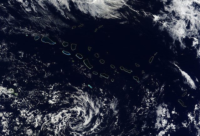
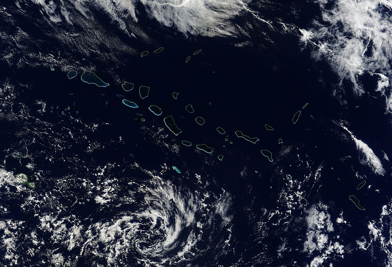
English: Natural-colour image of the north-western portion of the archipelago, including the largest coral atoll in the group, Rangiroa. Delicate rings of iridescent blue-green surround deep blue waters and clouds float overhead. At the north-western extent of the island chain—including islands shown in this image—rocks date to roughly 65 million years ago.
|
| Date | |
| Source | NASA Earth Observatory |
| Author | Jeff Schmaltz |
Image captured by the Moderate Resolution Imaging Spectroradiometer (MODIS) on NASA’s Terra satellite.
Licensing[edit]
| This file is in the public domain in the United States because it was solely created by NASA. NASA copyright policy states that "NASA material is not protected by copyright unless noted". (See Template:PD-USGov, NASA copyright policy page or JPL Image Use Policy.) | ||
 |
Warnings:
|
| Annotations | This image is annotated: View the annotations at Commons |
File history
Click on a date/time to view the file as it appeared at that time.
| Date/Time | Thumbnail | Dimensions | User | Comment | |
|---|---|---|---|---|---|
| current | 17:24, 13 July 2010 | | 4,400 × 3,000 (2.05 MB) | Originalwana (talk | contribs) | {{Information |Description={{en|1=Natural-colour image of the north-western portion of the archipelago, including the largest coral atoll in the group, Rangiroa. Delicate rings of iridescent blue-green surround deep blue [[W |
You cannot overwrite this file.
File usage on Commons
The following 42 pages use this file:
- French Polynesia
- Category:1998 in French Polynesia
- Category:2000 in French Polynesia
- Category:2004 in French Polynesia
- Category:2005 in French Polynesia
- Category:2006 in French Polynesia
- Category:2007 in French Polynesia
- Category:2008 in French Polynesia
- Category:2009 in French Polynesia
- Category:2013 in French Polynesia
- Category:2015 in French Polynesia
- Category:2018 in French Polynesia
- Category:Airports in French Polynesia
- Category:Animals of French Polynesia
- Category:Archipelagoes of French Polynesia
- Category:Bays of French Polynesia
- Category:Beaches of French Polynesia
- Category:Beauty pageants in French Polynesia
- Category:Births in French Polynesia
- Category:Bodies of water in French Polynesia
- Category:Culture of French Polynesia
- Category:Deaths in French Polynesia
- Category:Events in French Polynesia
- Category:Festivals of French Polynesia
- Category:French Polynesia
- Category:French Polynesia by century
- Category:French Polynesia by decade
- Category:French Polynesia by year
- Category:French Polynesia in the 1880s
- Category:French Polynesia in the 1900s
- Category:French Polynesia in the 1910s
- Category:French Polynesia in the 1920s
- Category:French Polynesia in the 1940s
- Category:French Polynesia in the 2000s
- Category:French Polynesia in the 2010s
- Category:Islands of French Polynesia
- Category:Landforms of French Polynesia
- Category:Lighthouses in French Polynesia
- Category:Maps of French Polynesia
- Category:Rivers of French Polynesia
- Category:Transport infrastructure in French Polynesia
- Category:Volcanoes in French Polynesia
File usage on other wikis
The following other wikis use this file:
- Usage on arz.wikipedia.org
- Usage on ast.wikipedia.org
- Usage on az.wikipedia.org
- Usage on ca.wikipedia.org
- Usage on cs.wikipedia.org
- Usage on cy.wikipedia.org
- Usage on diq.wikipedia.org
- Usage on en.wikipedia.org
- Usage on eo.wikipedia.org
- Usage on fa.wikipedia.org
- Usage on fr.wikinews.org
- Usage on fr.wikivoyage.org
- Usage on gd.wikipedia.org
- Usage on gl.wikipedia.org
- Usage on hu.wikipedia.org
- Usage on it.wikipedia.org
- Usage on ka.wikipedia.org
- Usage on la.wikipedia.org
- Usage on pl.wikipedia.org
- Usage on ru.wikipedia.org
- Usage on ru.wikinews.org
- Usage on sk.wikipedia.org
- Usage on vec.wikipedia.org
- Usage on www.wikidata.org