File:Antiquities of Samarkand. Kurgan in the Vicinity of Samarkand. Location of Pai Fasad. General View of the Tumulus from Its Base WDL3707.png
Jump to navigation
Jump to search

Size of this preview: 800 × 564 pixels. Other resolutions: 320 × 226 pixels | 640 × 451 pixels | 1,024 × 722 pixels | 1,280 × 902 pixels | 1,453 × 1,024 pixels.
Original file (1,453 × 1,024 pixels, file size: 1.85 MB, MIME type: image/png)
Captions
Captions
Add a one-line explanation of what this file represents
Summary[edit]
| Author |
Русский: Богаевский, Николай Владимирович, 1843—1912 гг.
Français : Bogaevskii, Nikolaï V., 1843-1912
English: Bogaevskii, Nikolai V., 1843-1912
中文:亚历山大·L·坤,1840-1888 年
Português: Bogaevskii, Nikolai V., 1843-1912
العربية: بوغافسكي، نيكولاي ف.، 1843-1912
Español: Bogaevskii, Nikolai V., 1843-1912 |
| Title |
Русский: Самаркандские древности. Курган в окрестностях Самарканда. Местность Пай Фасад. Общий вид кургана от его основания
Français : Antiquités de Samarcande. Kourgane, à proximité de Samarcande. Emplacement de Pai Fasad. Vue d'ensemble de la butte depuis sa base
English: Antiquities of Samarkand. Kurgan in the Vicinity of Samarkand. Location of Pai Fasad. General View of the Tumulus from Its Base
中文:撒马尔罕古迹。撒马尔罕附近的坟冢。派·法沙德的安葬地。从坟冢底部看到的坟冢全景
Português: Antiguidades de Samarcanda. Kurgan nos arredores de Samarcanda. Localização: Pai Fasad. Vista geral da mamoa desde sua base
العربية: آثار سمرقند. "كورغان" بالقرب من سمرقند. موقع باي فاساد. منظر عام للركام الترابي من قاعدته
Español: Antigüedades de Samarcanda. Kurgan cerca de Samarcanda. Pai Fasad. Vista general del túmulo desde su base |
| Description |
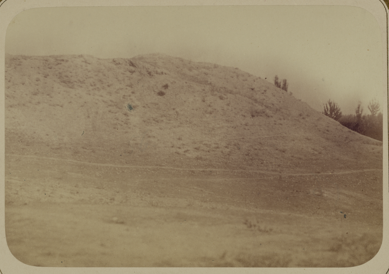
Русский: Эта фотография развалин крепости в Пай Фасад, недалеко от Самарканда (Узбекистан), содержится в археологической части "Туркестанского альбома". Шеститомное фотографическое исследование было проведено в 1871—1872 гг. под руководством генерала Константина П. фон Кауфмана, первого генерал-губернатора (1867—1882 гг.) Туркестана, как называли территорию Центральной Азии, принадлежавшую Российской империи. В альбоме уделяется особое внимание архитектурному наследию Самарканда. Показанный здесь курган, возможно, является останками одной из крепостей, построенных согдийскими королями до арабского завоевания на рубеже VIII века. Подобные укрепления не только охраняли подходы к Самарканду или Мараканде, как его тогда называли, они также защищали караваны Великого шелкового пути, направлявшиеся из Китая. Разрушенные стены, показанные на этом снимке, возвышаются над окружающими равнинами, которые в древние времена обильно орошались. Влажная земля, в свою очередь, обеспечивала достаточный запас строительного материала, используемого в технологии, известной как pakhsa (утрамбованная земля), в основе которой лежало сжатие влажной земли, смешанной с глиной и гравием, в прочные блоки. Эти крепости в большинстве случаев были разграблены арабами, и значительная часть их стен была постепенно разрушена эрозией. В качестве верхней части на это основание могли быть добавлены саманные кирпичные постройки.
Курганы (захоронения); Фотографические исследования; Тюркские народы Français : Cette photographie des ruines d'une forteresse à Pai Fasad, près de Samarcande (Ouzbékistan), est extraite de l'ouvrage archéologique Album du Turkestan. Cet inventaire photographique, en six volumes, fut réalisé entre 1871 et 1872 sous le patronage du général Konstantin P. von Kaufman, premier gouverneur général (1867-1882) du Turkestan, nom donné aux territoires d'Asie centrale de l'Empire russe. L'album consacre une attention particulière à l'héritage de l'architecture de Samarcande. La butte présentée ici est probablement un vestige de l'une des forteresses construites par les rois sogdiens avant la conquête des arabes, au tournant du VIIIe siècle. Non seulement ces fortifications défendaient les abords de Samarcande, ou Maracanda de son nom à l'époque, mais elles protégeaient également les caravanes de la route de la soie venant de Chine. Dans cette vue, les murs en ruines s'élèvent sur les plaines environnantes, qui étaient largement irriguées dans l'antiquité. Le sol humide, à son tour, fournissait des matériaux de construction en quantité suffisante, utilisés avec la technique appelée pakhsa (pisé), qui consiste à comprimer de la terre humide, argileuse et graveleuse en blocs durables. Ces forteresses étaient généralement mises à sac par les Arabes et, peu à peu avec l'érosion, de grands segments de leurs murs se mélangèrent de nouveau à la terre. Des structures en briques d'adobe pouvaient être ajoutées sur cette base.
Tumulus (enterrement); Inventaires photographiques; Peuples turciques English: This photograph of fortress ruins at Pai Fasad, near Samarkand (Uzbekistan), is from the archeological part of Turkestan Album. The six-volume photographic survey was produced in 1871-72 under the patronage of General Konstantin P. von Kaufman, the first governor-general (1867-82) of Turkestan, as the Russian Empire’s Central Asian territories were called. The album devotes special attention to Samarkand’s architectural heritage. The mound shown here is possibly a remnant of one of the fortresses built by Sogdian kings before the Arab conquest at the turn of the 8th century. Such fortifications not only defended the approaches to Samarkand, or Maracanda, as it was then called, they also protected Silk Road caravans from China. The ruined walls in this view rise from the surrounding plains, which were extensively irrigated in ancient times. The moist earth, in turn, provided an ample supply of building material that was used in a technique known as pakhsa (rammed earth), which compresses damp soil mixed with clay and gravel into durable blocks. Such fortresses usually were sacked by the Arabs, and large segments of their walls have gradually eroded back into the earth. Adobe brick structures could be added on top of this base.
Mounds (Burial); Photographic surveys; Turkic peoples 中文:这张照片出自《土耳其斯坦相册》的考古部分,展示的是撒马尔罕(乌兹别克斯坦)附近的派·法沙德 (Pai Fasad) 堡垒坟冢遗址。这份六卷本摄影调查作品制作于 1871-72 年间,是在俄罗斯驻土耳其斯坦(俄罗斯帝国中亚属地的名称)的首任总督康斯坦丁·P·凡·考夫曼(Konstantin P. von Kaufman,1867-82 年在位)赞助下完成的。相册特别展示了撒马尔罕的建筑遗产。这张照片展示的坟冢遗迹可能是在 8 世纪初期阿拉伯对外征服战争开始之前,由古索格代亚那国王修建的。此类防御工事不仅保卫着通往撒马尔罕城(又称马拉坎达)的道路,还保护着来自中国丝绸之路的商队。在这幅照片中,堡垒的残破墙体兀立在辽阔的平原当中,在远古时期,这里曾被大规模灌溉。正因为如此,潮湿的泥土也可作为资源充足的建筑材料,应用到一种名为 pakhsa(夯土)的技术中,这种技术能够将混合有粘土和碎石的潮湿土壤压缩成耐用的建筑块料。这类堡垒一般都遭受过阿拉伯人的洗劫,墙体大部分也逐渐化为泥土。风干的砖坯结构可用在以这种材料压制而成的基底之上。
坟冢(墓葬); 摄影勘察作品; 突厥人 Português: Esta fotografia de ruínas de fortalezas em Pai Fasad, próxima a Samarcanda (Uzbequistão), faz parte da seção arqueológica do Álbum do Turquestão. Este levantamento fotográfico em seis volumes foi produzido em 1871-1872 sob o patrocínio do General Konstantin P. von Kaufman, primeiro governador-geral (1867-1882) do Turquestão, nome dado aos territórios da Ásia Central do Império Russo. O álbum dedica atenção especial ao patrimônio arquitetônico de Samarcanda. O monte mostrado aqui é, possivelmente, o que restou de uma das fortalezas construídas pelos reis sogdianos antes da conquista árabe na virada do século VIII. Elas não apenas defenderam as aproximações até Samarcanda, ou Maracanda, como era então chamada, como também protegeram as caravanas da Rota da Seda da China. As paredes em ruínas nesta imagem erguem-se das planícies vizinhas, as quais eram amplamente irrigadas nos tempos antigos. A terra úmida, por sua vez, forneceu uma fonte ampla de material de construção que foi utilizado em uma técnica conhecida como pakhsa (terra batida), que comprime o solo úmido misturado com argila e cascalho em blocos resistentes. Tais fortalezas eram normalmente saqueadas pelos árabes, e grandes segmentos de suas paredes desgastaram-se voltando, assim, gradualmente, à terra. Estruturas de tijolos adobe secos podiam ser adicionadas sobre esta base.
Montes (sepultamento); Levantamentos fotográficos; Povos túrquicos العربية: تُوجد هذه الصورة لأطلال حصن في باي فاساد، بالقرب من سمرقند (أوزبكستان)، ضمن الجزء الأثري من ألبوم تُرْكِستان. تم إصدار البحث التصويري المكوّن من ستة مجلدات بين العامين 1871-1872 تحت رعاية الجنرال كونستانتين ب. فون كوفمان، الحاكم العام الأول لتُرْكِستان (1867-1882)، وهو ما كان يُطلق على أراضي وسط آسيا التابعة للإمبراطورية الروسية. يولي الألبوم اهتماماً خاصاً بالتراث المعماري بسمرقند. يُرجح أن يكون المتراس الظاهر هنا من بقايا إحدى الحصون التي بناها ملوك سوغديان قبل الغزو العربي في مطلع القرن الثامن. لم تَحْمِ تلك الحصون الطرق المؤدية إلى سمرقند فحسب، أو مرقندا كما كانت تُسمى في ذلك الوقت، ولكنها أيضاً شكّلت دفاعات لحماية قوافل طريق الحرير القادمة من الصين. ترتفع الحوائط المتداعية في هذا المنظر بين السهول المحيطة، والتي كانت قديماً يتم ريها على نطاق واسع. تُوفر التربة الرطبة، بدورها، مصدراً وفيراً لمواد البناء، والتي كانت تُعالج بتقنية تُعرف باسم باخسا (التربة المضغوطة)، والتي يتم فيها ضغط التربة الرطبة ممزوجة بالطين والحصى وتحويلها إلى قوالب صلبة متينة. وعادةً ما كان العرب يقومون بنهب هذه الحصون وقد تآكلت قطع كبيرة من جدرانها تدريجياً حتى تساوت مع الأرض. وعادةً ما كانت تُضاف هياكل من الطوب اللبن على رأس هذه القاعدة.
التُرَب (مدافن); البحوث التصويرية; الشعوب التركية Español: Esta fotografía de las ruinas de una fortaleza en Pai Fasad, cerca de Samarcanda (Uzbekistán), proviene de la parte arqueológica del Álbum de Turquestán. El estudio fotográfico en seis volúmenes se produjo entre 1871 y 1872, bajo el patrocinio del general Konstantín P. von Kaufman, el primer gobernador general (1867-1882) de Turquestán, como se conocían a los territorios del Imperio ruso en Asia Central. En el álbum se presta especial atención a la herencia arquitectónica de Samarcanda. El montículo que se muestra aquí es, posiblemente, un remanente de una de las fortalezas construidas por los reyes sogdianos antes de la conquista árabe a principios del siglo VIII. Este tipo de fortificaciones no solo defendían a Samarcanda (o Maracanda, como se llamaba entonces) de los ataques, sino que también protegían a las caravanas de la Ruta de la Seda de China. Los muros en ruinas en esta vista se elevan sobre las llanuras circundantes, muy irrigadas en la antigüedad. La tierra húmeda, a su vez, proporcionaba un amplio suministro de material de construcción que se utilizaba en una técnica conocida como pakhsa (tierra apisonada), que consistía en comprimir tierra húmeda, mezclándola con barro y grava, para formar bloques duraderos. Normalmente los árabes saqueaban este tipo de fortalezas, y la erosión hizo que grandes segmentos de sus murallas gradualmente se convirtieran en polvo. Sobre esta base se podían agregar estructuras de ladrillos de adobe.
Montículos (entierro); Estudios fotográficos; Pueblos túrquicos |
| Date | between 1868 and 1872 |
| Medium |
Русский: Эстампы, фотографии
Français : Images, photographies
English: Prints, Photographs
中文:图像, 摄影作品
Português: Imagens, Fotografias
العربية: مطبوعات، صور فوتوغرافية
Español: Imágenes, Fotografías |
| Dimensions |
English: 1 photographic print : albumen |
| Collection |
Русский: Библиотека Конгресса
Français : Bibliothèque du Congrès
English: Library of Congress
中文:国会图书馆
Português: Biblioteca do Congresso
العربية: مكتبة الكونغرس
Español: Biblioteca del Congreso |
| Current location |
Русский: Изображения из "Туркестанского альбома"
Français : Images de l'Album du Turkestan
English: Images from the Turkestan Album
中文:图片出自《土耳其斯坦相册》
Português: Imagens do Álbum do Turquestão
العربية: صور من ألبوم تُرْكِستان
Español: Imágenes del Álbum de Turquestán |
| Place of creation |
Русский: Самарканд вилоят
Français : Province de Samarcande
English: Samarqand Viloyati
中文:撒马尔罕州
Português: Província de Samarcanda
العربية: ولاية سمرقند
Español: Provincia de Samarcanda |
| Notes |
Original language title: Самаркандския древности. Курганы в окрестностях города. Местность пай фасад. Общий вид Холма с его подошвы Русский: Иллюстрация в: Туркестанский альбом, Часть археологическая, 1871—1872 гг., часть 1, том 2, пластина 154.
Français : Illustration provenant de : Album du Turkestan, ouvrage archéologique, 1871-1872, partie 1, volume 2, planche 154.
English: Illustration in: Turkestan Album, Archaeological Part, 1871-1872, part 1, volume 2, plate 154.
中文:插图出自:《土耳其斯坦相册》,考古部分,1871-1872 年,第 1 部分,第 2 卷,第 154 页。
Português: Ilustração em: Álbum do Turquestão, seção arqueológica, 1871-1872, parte 1, volume 2, placa 154.
العربية: رسم إيضاحي في: ألبوم تُرْكِستان، الجزء الأثري، 1871-1872، الجزء الأول، المجلد الثاني، اللوحة 154.
Español: Ilustración en: Álbum de Turquestán, parte arqueológica, 1871-1872, parte 1, volumen 2, lámina 154. |
| References | http://hdl.loc.gov/loc.wdl/dlc.3707 |
| Source/Photographer |
|
Licensing[edit]
|
This is a faithful photographic reproduction of a two-dimensional, public domain work of art. The work of art itself is in the public domain for the following reason:
The official position taken by the Wikimedia Foundation is that "faithful reproductions of two-dimensional public domain works of art are public domain".
This photographic reproduction is therefore also considered to be in the public domain in the United States. In other jurisdictions, re-use of this content may be restricted; see Reuse of PD-Art photographs for details. | ||||
File history
Click on a date/time to view the file as it appeared at that time.
| Date/Time | Thumbnail | Dimensions | User | Comment | |
|---|---|---|---|---|---|
| current | 09:32, 2 March 2014 | | 1,453 × 1,024 (1.85 MB) | Fæ (talk | contribs) | =={{int:filedesc}}== {{Artwork |artist = |author ={{ru|1=Богаевский, Николай Владимирович, 1843—1912 гг.}} {{fr|1=Bogaevskii, Nikolaï V., 1843-1912}} {{en|1=Bogaevskii, Nikolai V., 1843-1912}} {{zh|1=亚历山大·L... |
You cannot overwrite this file.
File usage on Commons
The following page uses this file:
File usage on other wikis
The following other wikis use this file:
- Usage on ar.wikibooks.org