File:Ansett 703 accident site view.png
Jump to navigation
Jump to search

Size of this preview: 623 × 599 pixels. Other resolutions: 249 × 240 pixels | 499 × 480 pixels | 798 × 768 pixels | 1,064 × 1,024 pixels | 1,400 × 1,347 pixels.
Original file (1,400 × 1,347 pixels, file size: 976 KB, MIME type: image/png)
Captions
Captions
Add a one-line explanation of what this file represents
Summary[edit]
| Description |
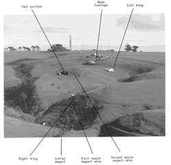
English: Annotated general view of the accident site of Ansett New Zealand flight 703, which collided with terrain on approach to Palmerston North Airport on 9 June 1995. |
| Date | |
| Source | AO-1995-011 De Havilland DHC-8 ZK-NEY, controlled flight into terrain, near Palmerston North, 9 June 1995 |
| Author | Transport Accident Investigation Commission (TAIC) |
| Permission (Reusing this file) |
TAIC copyright |
| Camera location | | View this and other nearby images on: OpenStreetMap |
|---|
Licensing[edit]
This file is licensed under the Creative Commons Attribution 4.0 International license.
- You are free:
- to share – to copy, distribute and transmit the work
- to remix – to adapt the work
- Under the following conditions:
- attribution – You must give appropriate credit, provide a link to the license, and indicate if changes were made. You may do so in any reasonable manner, but not in any way that suggests the licensor endorses you or your use.
File history
Click on a date/time to view the file as it appeared at that time.
| Date/Time | Thumbnail | Dimensions | User | Comment | |
|---|---|---|---|---|---|
| current | 05:49, 16 July 2022 | | 1,400 × 1,347 (976 KB) | Lcmortensen (talk | contribs) | Uploaded a work by Transport Accident Investigation Commission from [https://www.taic.org.nz/sites/default/files/inquiry/documents/95-011.pdf AO-1995-011 De Havilland DHC-8 ZK-NEY, controlled flight into terrain, near Palmerston North, 9 June 1995] with UploadWizard |
You cannot overwrite this file.
File usage on Commons
There are no pages that use this file.
File usage on other wikis
The following other wikis use this file:
- Usage on en.wikipedia.org
- Usage on fr.wikipedia.org
- Usage on it.wikipedia.org
- Usage on ru.wikipedia.org
- Usage on www.wikidata.org