File:Angliae, Scotiae, Et Hiberniae, Sive Britannicar- Insularum Descriptio (cropped).jpg

Original file (11,915 × 8,215 pixels, file size: 29.46 MB, MIME type: image/jpeg)
Captions
Captions
Summary[edit]
| Title |
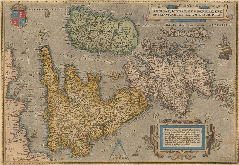
Angliae, Scotiae, Et Hiberniae, Sive Britannicar: Insularum Descriptio [cartographic material]. |
|||||||||||||||||||||||
| Description |
English: Map of Grat Britain and Ireland, oriented towards the west, dran by Abraham Ortelius and published by Christophe Plantin, circa 1588
עברית: מפת בריטניה הגדולה, נוצרה בידי קרטוגרף אברהם אורטליוס ופורסמה בידי כריסוף פלנטין |
|||||||||||||||||||||||
| Date | circa 1588 | |||||||||||||||||||||||
| Source | National Library of Israel | |||||||||||||||||||||||
| Creator |
|
|||||||||||||||||||||||
| Credit line | אוסף המפות ע"ש ערן לאור | |||||||||||||||||||||||
| Georeferencing | If inappropriate please set warp_status = skip to hide. | |||||||||||||||||||||||
| Archival data | ||||||||||||||||||||||||
| Collection |
|
|||||||||||||||||||||||
| Dimensions | 376x500x540 mm | |||||||||||||||||||||||

.jpg&action=edit§ion=1)
Licensing[edit]
.jpg&action=edit§ion=2)
|
This is a faithful photographic reproduction of a two-dimensional, public domain work of art. The work of art itself is in the public domain for the following reason:
The official position taken by the Wikimedia Foundation is that "faithful reproductions of two-dimensional public domain works of art are public domain".
This photographic reproduction is therefore also considered to be in the public domain in the United States. In other jurisdictions, re-use of this content may be restricted; see Reuse of PD-Art photographs for details. | ||||
File history
Click on a date/time to view the file as it appeared at that time.
| Date/Time | Thumbnail | Dimensions | User | Comment | |
|---|---|---|---|---|---|
| current | 11:37, 21 July 2022 | | 11,915 × 8,215 (29.46 MB) | Shimon.tre (talk | contribs) | == {{int:filedesc}} == {{map |Title=Angliae, Scotiae, Et Hiberniae, Sive Britannicar: Insularum Descriptio [cartographic material]. |Description= {{en|1=Map of Grat Britain and Ireland, oriented towards the west, dran by Abraham Ortelius and published by Christophe Plantin, circa 1588}} {{he|1=מפת בריטניה הגדולה, נוצרה בידי קרטוגרף אברהם אורטליוס ופורסמה בידי כריסוף פלנטין }} |Dimensions = 376x500x540 mm |Source=[https://www.nli.org.il/he/maps/NNL_ALEPH002582039/NLI#$FL35474989 National Libr... |
You cannot overwrite this file.
File usage on Commons
The following page uses this file:
File usage on other wikis
The following other wikis use this file:
- Usage on en.wikipedia.org
.jpg&oldid=795580231)