File:Angers (Maine-et-Loire) (26481064195).jpg

Original file (4,928 × 3,264 pixels, file size: 10.56 MB, MIME type: image/jpeg)
Captions
Captions
Summary
[edit]_(26481064195).jpg&action=edit§ion=1)
| Description |
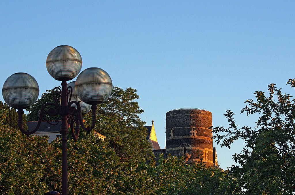
Angers (Maine-et-Loire) Le château (Château des ducs d'Anjou). La Tour du Moulin. Au Moment des guerres de religion, le roi Henri III donne l'ordre de raser purement et simplement la citadelle : il redoute qu'elle ne soit conquise par les Protestants qui tiendraient alors un site stratégique de première importance. Mais le gouverneur Donadieu de Puycharic ne fait pas de zèle. Il prend tout son temps pour obéir au roi, et les travaux de démolition traînent en longueur puis finissent par s'arrêter. Le château est toujours debout, même si les tours ont été décapitées et ont perdus au passage les jolis toits coniques dont elles étaient coiffées. Pour avoir une meilleure idée de leur hauteur initiale, il faut observer celle qui se trouve à l'angle Nord, et qui domine la terrasse du Bout-du-Monde. Cette tour a en effet en grande partie échappé au démolisseurs, même si le moulin à vent qui avait été construit à son sommet a aujourd'hui disparu. Grâce à ce moulin, la garnison pouvait subvenir à ses besoins en farine et en pain, même en cas de siège. (Angers mystérieux par Pierre-Louis Augereau) A l’intérieur de la cour, un deuxième château, le Logis Royal, a été construit au XVème, pour l’agrément et est donc plus élégant et plus confortable. Ce bâtiment a subit un grave incendie en 2009. The Tower Mill. Moment in the religious wars, King Henry III gave the order to raze the Citadel: King fears that the citadel was conquered and used by Protestants. Governor Donadieu de Puycharic does not execute immediately the king's order. Demolition works are stopped. The castle is still standing. But the towers were decapitated and have lost their nice conical roofs. The mill which covered the Tour Mill has now disappeared. The mill was used to produce flour for the garrison, even if the blockade. Inside the courtyard, a second castle, the Logis Royal, was built in the fifteenth, for approval. The building has undergone a major fire in 2009. |
| Date | Taken on 19 June 2014, 21:35 |
| Source | Angers (Maine-et-Loire) |
| Author | Daniel Jolivet |
| Camera location | | View this and other nearby images on: OpenStreetMap |
|---|
_(26481064195).jpg¶ms=047.472652_N_-000.557945_E_globe:Earth_type:camera_source:Flickr_&language=en)
Licensing
[edit]_(26481064195).jpg&action=edit§ion=2)
- You are free:
- to share – to copy, distribute and transmit the work
- to remix – to adapt the work
- Under the following conditions:
- attribution – You must give appropriate credit, provide a link to the license, and indicate if changes were made. You may do so in any reasonable manner, but not in any way that suggests the licensor endorses you or your use.
| This image was originally posted to Flickr by sybarite48 at https://flickr.com/photos/26082117@N07/26481064195 (archive). It was reviewed on 14 November 2017 by FlickreviewR 2 and was confirmed to be licensed under the terms of the cc-by-2.0. |

|
The categories of this image need checking. You can do so here.
|
_(26481064195).jpg&action=edit&withJS=MediaWiki:Catcheck.js)
File history
Click on a date/time to view the file as it appeared at that time.
| Date/Time | Thumbnail | Dimensions | User | Comment | |
|---|---|---|---|---|---|
| current | 15:41, 14 November 2017 | | 4,928 × 3,264 (10.56 MB) | Thesupermat2 (talk | contribs) | Transferred from Flickr via Flickr2Commons |
You cannot overwrite this file.
File usage on Commons
There are no pages that use this file.
_(26481064195).jpg&oldid=795522482)