File:Ancient Egypt map-it.svg
Jump to navigation
Jump to search

Size of this PNG preview of this SVG file: 293 × 598 pixels. Other resolutions: 117 × 240 pixels | 235 × 480 pixels | 376 × 768 pixels | 501 × 1,024 pixels | 1,003 × 2,048 pixels | 1,577 × 3,219 pixels.
Original file (SVG file, nominally 1,577 × 3,219 pixels, file size: 994 KB)
Captions
Captions
Add a one-line explanation of what this file represents
Summary[edit]
| Description |
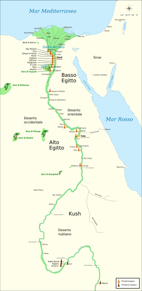
Italiano: Mappa dell'antico Egitto, con il Nilo fino alla quinta cataratta, le maggiori città e siti del periodo dinastico (dal 3150 aC al 30 aC circa). Il Cairo e Gerusalemme sono mostrate come riferimento. |
| Date | (UTC) |
| Source |
This file was derived from: Ancient Egypt map-en.svg:  |
| Author |
|
| Other versions |
[]
|


|
This SVG file contains embedded text that can be translated into your language, using any capable SVG editor, text editor or the SVG Translate tool. For more information see: About translating SVG files. |
| This is a retouched picture, which means that it has been digitally altered from its original version. Modifications: + pyramid sites. The original can be viewed here: Ancient Egypt map-en.svg:
|
Licensing[edit]
I, the copyright holder of this work, hereby publish it under the following licenses:
This file is licensed under the Creative Commons Attribution-Share Alike 3.0 Unported, 2.5 Generic, 2.0 Generic and 1.0 Generic license.
- You are free:
- to share – to copy, distribute and transmit the work
- to remix – to adapt the work
- Under the following conditions:
- attribution – You must give appropriate credit, provide a link to the license, and indicate if changes were made. You may do so in any reasonable manner, but not in any way that suggests the licensor endorses you or your use.
- share alike – If you remix, transform, or build upon the material, you must distribute your contributions under the same or compatible license as the original.

|
Permission is granted to copy, distribute and/or modify this document under the terms of the GNU Free Documentation License, Version 1.2 or any later version published by the Free Software Foundation; with no Invariant Sections, no Front-Cover Texts, and no Back-Cover Texts. A copy of the license is included in the section entitled GNU Free Documentation License. |
You may select the license of your choice.
Original upload log[edit]
This image is a derivative work of the following images:
- File:Ancient_Egypt_map-en.svg licensed with Cc-by-sa-3.0,2.5,2.0,1.0, GFDL
- 2009-02-20T11:28:29Z Bibi Saint-Pol 1577x3219 (422457 Bytes) fix translation mistake on the windrose
- 2009-01-30T12:13:53Z Bibi Saint-Pol 1577x3219 (422444 Bytes) fix position of Nile Delta
- 2009-01-29T12:21:11Z Bibi Saint-Pol 1577x3219 (422383 Bytes) remove wrong text, adjust frame
- 2009-01-29T12:05:11Z Bibi Saint-Pol 1577x3219 (422757 Bytes) {{Assessments|1=Ancient Egypt map.svg|enwiki=1}} __NOTOC__ == {{int:filedesc}} == {{inkscape}} {{Information |Description= {{en|Map of Ancient Egypt, showing the Nile up to the fifth cataract, and major cities and sites of th
File history
Click on a date/time to view the file as it appeared at that time.
| Date/Time | Thumbnail | Dimensions | User | Comment | |
|---|---|---|---|---|---|
| current | 08:49, 6 January 2014 | | 1,577 × 3,219 (994 KB) | Fulvio314 (talk | contribs) | Legenda |
| 18:14, 5 January 2014 |  | 1,577 × 3,219 (1.04 MB) | Fulvio314 (talk | contribs) | + sites | |
| 18:36, 21 October 2013 |  | 1,577 × 3,219 (1 MB) | Fulvio314 (talk | contribs) | +sites | |
| 19:53, 14 October 2013 |  | 1,577 × 3,219 (320 KB) | Fulvio314 (talk | contribs) | {{Information |Description={{it|Mappa dell'antico Egitto, con il Nilo fino alla quinta cataratta, le maggiori città e siti del periodo dinastico (dal 3150 aC al 30 aC circa). Il Cairo e Gerusalemme sono mostrate come riferimento.}} |Source={{Derived f... |
You cannot overwrite this file.
File usage on Commons
The following 28 pages use this file:
- User:Fulvio314/commons gallery
- File:Ancient Egypt map-af.svg
- File:Ancient Egypt map-ar.png
- File:Ancient Egypt map-de.svg
- File:Ancient Egypt map-el.svg
- File:Ancient Egypt map-en.svg
- File:Ancient Egypt map-es.svg
- File:Ancient Egypt map-fr.svg
- File:Ancient Egypt map-hiero.svg
- File:Ancient Egypt map-it.svg
- File:Ancient Egypt map-la.png
- File:Ancient Egypt map-la.svg
- File:Ancient Egypt map-mk.svg
- File:Ancient Egypt map-nl.svg
- File:Ancient Egypt map-no.svg
- File:Ancient Egypt map-pl.svg
- File:Ancient Egypt map-pt.svg
- File:Ancient Egypt map-ru.svg
- File:Ancient Egypt map-sk.svg
- File:Ancient Egypt map-sr.svg
- File:Ancient Egypt map-vi.svg
- File:Ancient Egypt map-zh-hans.svg
- File:Antik Mısır haritası.png
- File:Antzinako Egipto.svg
- File:Mapo de antikva Egiptio.jpg
- File:Mapo de antikva Egiptio - centro.jpg
- File:Muistne Egiptus.png
- Template:Other versions/Ancient Egypt map
File usage on other wikis
The following other wikis use this file:
- Usage on it.wikipedia.org
- Periodo Predinastico (Egitto)
- Periodo Protodinastico (Egitto)
- Antico Regno (Egitto)
- Primo periodo intermedio
- Storia dell'antico Egitto
- Piramidi egizie
- Antico Egitto
- Lista delle piramidi egizie
- Piramidi nubiane
- Progetto:Laboratorio grafico/Immagini da migliorare/Archivio risolte/153
- Utente:Madaki/sandbox4
- Discussioni utente:Hotepibre/Sandbox
- Utente:Hotepibre/Sandbox2
- Marina militare egizia