File:Anchorage, Alaska (MODIS 2019-02-17).jpg
Jump to navigation
Jump to search

Size of this preview: 789 × 600 pixels. Other resolutions: 316 × 240 pixels | 631 × 480 pixels | 1,010 × 768 pixels | 1,280 × 973 pixels | 2,560 × 1,947 pixels | 2,847 × 2,165 pixels.
Original file (2,847 × 2,165 pixels, file size: 998 KB, MIME type: image/jpeg)
Captions
Captions
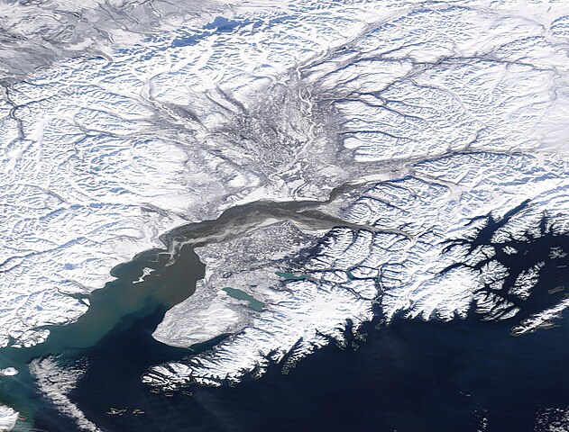
The Moderate Resolution Imaging Spectroradiometer (MODIS) on board NASA’s Terra satellite acquired a true-color centered on Anchorage, Alaska.
Summary[edit]
.jpg&action=edit§ion=1)
| Description |
English: The city of Anchorage, Alaska, originated in 1914 as a port for the construction of the Alaska Railroad. Railroad construction continued until 1923, when it was finally completed. Anchorage was incorporated in 1920 and the city’s economy centered on rail transportation through the 1930’s. The name was taken from the port’s origins—the anchorage at the mouth of Ship Creek.
The city is located in South Central Alaska, north of the Kenai Peninsula, northwest of Prince William Sound and south of Mount McKinley. It sits in the Anchorage “Bowl”, a strop of coastal lowland extending to the slopes of the Chugach Mountains to the east. Knik Arm is a tidal inlet which lies to the west and north of the city. The Turnagin Arm, a fjord known for extremely high tides, sits south of Anchorage. The Moderate Resolution Imaging Spectroradiometer (MODIS) on board NASA’s Terra satellite acquired a true-color centered on Anchorage, Alaska. The Kenai Peninsula sits on the Gulf of Alaska in the southern section of the image. North of the Kenai Peninsula, Anchorage sits on the point of land formed by the Turnagin Arm and the Knik Arm. |
||
| Date | Taken on 14 February 2019 | ||
| Source |
Anchorage, Alaska (direct link)
|
||
| Author | MODIS Land Rapid Response Team, NASA GSFC |
| This media is a product of the Terra mission Credit and attribution belongs to the mission team, if not already specified in the "author" row |
Licensing[edit]
.jpg&action=edit§ion=2)
| This file is in the public domain in the United States because it was solely created by NASA. NASA copyright policy states that "NASA material is not protected by copyright unless noted". (See Template:PD-USGov, NASA copyright policy page or JPL Image Use Policy.) | ||
 |
Warnings:
|
File history
Click on a date/time to view the file as it appeared at that time.
| Date/Time | Thumbnail | Dimensions | User | Comment | |
|---|---|---|---|---|---|
| current | 03:30, 17 February 2024 | | 2,847 × 2,165 (998 KB) | OptimusPrimeBot (talk | contribs) | #Spacemedia - Upload of http://modis.gsfc.nasa.gov/gallery/images/image02172019_250m.jpg via Commons:Spacemedia |
You cannot overwrite this file.
File usage on Commons
There are no pages that use this file.
.jpg&oldid=852696071)